Vrolikheid
177 on the cadastre · on record 1822–1934 · show on the map
- Farm number
- No. 177
- On the cadastre
- 177, whole farmregistered as VROLYKHEID
- District
- Prince Albert
- Modern surveyed area
- 5664.6 ha
Why this farm is here
Jacobus Johannes Oosthuizen (b.1784) held it. 8 km from Klaarstroom.
Jacobus Johannes Oosthuizen (b.1784) is on record on this ground directly. No trace needed.
- story A written history is set on this ground On 15 April 1841 loan ground becomes property
- story A written history names this ground Middelwater's story since 1777
- story A written history is set on this ground Vrolykheid's story
- story A written history names this ground From Petersburg to Klaarstroom, a history since 1777
- …and 2 more, listed in full further down this page.
Stories
- about this farm
On 15 April 1841 loan ground becomes property
One surveyor works the Koup for two seasons. Seven years later, on a single day, the Crown converts the loan farms to perpetual quitrent: twenty-one deeds on twenty parcels, and the map of the district is set for a century.
- mentions this farm
Middelwater's story since 1777
From a loan farm on the Zwartberg to eight cadastral parcels: the full documented history of Middelwater No. 169 - Stretch's 1833 survey for Okert Oosthuizen, the twelve-farm grant day of 1841, the 1883 resurvey and the 1884 quitrent to J.D.J. Oosthuysen 'and another', the portions cut off for a spring called Vaste Water and a place called Avondrust, and the 1990 power-line survey whose coordinates finally put the farm on a map.
- about this farm
Vrolykheid's story
The farm where the paper and the people disagree: Stretch's 1833 survey already carrying the names of portions not cut for another century, two titles granted on one day in 1841 - one to an Oosthuisen and one to an 'N. Hitge' whose deed four later portions cite instead - a Trieste immigrant who married a Hitge in 1844 and died holding the farm in 1890, and the death notice that finally put the Hitges on the ground.
- mentions this farm
From Petersburg to Klaarstroom, a history since 1777
The loan farm De Claar Stroom (Klaarstroom No. 178), granted 1777, is the ground Klaarstroom village stands on, not to be confused with Klaarstroom No. 184, which is Christian Hatting's grant 19 km west. Meiringspoort opened in 1858; twenty-seven erven were laid out on Petrus Oosthuizen's land and the village was called Petersburg for him. The erven were sold WITHOUT water rights. Who Petrus was is still unknown, and the one testable fact about him is a brother named Ockert.
- about this farm
Two Vrolykheid farms, far apart?
Two farms of one name, 400 km apart. The 1816 Tulbagh diagram names four neighbours; two of the surnames turn up in the Koup and only ONE survives being looked at. Jan de Bruin, whose 1823 estate held a farm the inventories call Rondabel, was baptised at Tulbagh in 1769, but the Theron who took Rondabel in 1868 was a Roggeveld man, and that thread is a coincidence of surname reported as one.
- mentions this farm
The brother-in-law who founded a town
Two daughters of Middelwater marry two van Zyl brothers in the 1830s. One stays. The other goes north on the trek and is dead by about 1840, and her husband lives another sixty-six years and lays out the Free State town of Brandfort on his farm Keerom - described in print as a Voortrekker from Prince Albert.
- mentions this farm
The van Vuurens of Wilgemond
Wilgemond No. 179 was surveyed in 1833 for a "Martinus van Veuren" and granted in 1841 to a "J.M.J. van Vuuren" - two sets of initials on Vrolikheid's western boundary. Four documents later they are a family, and on 22 December 1838 one of them married an Oosthuizen.
- mentions this farm
The ground cut, and then stitched back together
This project holds 124 boundary acts: 96 subdivisions and 20 consolidations. Sorted by date they tell one story with a turning point. The district cut ground for a hundred and fifty years; from 1970 it has only stitched.
- mentions this farm
Short years of great change, 1858-1860
Between February 1858 and February 1860 the Koup acquired a road to the sea, buried the couple the whole district descends from, laid out a village, had Crown land surveyed on its eastern edge, and met the industry that paid for the next forty years.
- set here
From Modder Fonteyn to the Koup, 1809-1841
A clerk from the Orphan Chamber rode out to de Modder Fonteyn on the Olifants River on 23 April 1809 and wrote down what was in the house, room by room, including a complete forge in a room called the winkel. The owner had died intestate and his wife before him. Eleven children are named with their ages, and the seven youngest were placed with their eldest brother, aged twenty-five, who had promised to raise and school them. He bought the farm for a thousand rixdollars; the other ten had to find ground elsewhere. Twenty-five years later Oosthuizen households held two of three adjoining farms along the north foot of the Swartberg; the middle one was a du Preez's.
- set here
Before the Koup: the Cango and the Olifants, 1760-1824
A prelude in timeline form. From Louis van Wyk's loan place Vergelegen in the Cango in 1760, through the van Tonder and van Wyk kin of Susanna Catharina van Tonder, to Ockert Oosthuizen's death on de Modder Fonteyn in 1809, the farm's passing out of the family, and his eldest son on Vrolykheid in the Koup by 1822. Each entry says why it belongs on the road.
What this farm became
From 1921 this ground stopped being one farm, and the story continues on the pieces cut from it. Its own record above ends there; what happened afterwards belongs to a portion, not to the whole.
- 1921 Wit Plaats (Vrolikheid No. 177 Ptn 1)
- 1934 Uitkyk Nek (Vrolikheid No. 177 Ptn 2)
- 1934 Lot B (Vrolikheid No. 177 Ptn 5)
- 1934 Faans Kraal (Vrolikheid No. 177 Ptn 4)
- 1934 Marinco (Vrolikheid No. 177 Ptn 3)
- 1934 Lot A (Vrolikheid No. 177 Ptn 6)
Who stood on this ground, and how they were related
Everyone the record places here - by deed, by residence, or by burial - and the kinship between each pair of them. Two numbers are given and they are deliberately kept apart. Steps is how far apart two people are in the family graph, counting a marriage as one step. The common ancestor is the nearest one they share by blood, with the year they were born. A pair four steps apart through a couple born in the 1750s is a relationship; a pair ten steps apart through a progenitor born in the 1630s is background, because almost everybody descends from him. Read both.
- 1822 Jacobus Johannes Oosthuizen (b.1784) held 1822 · lived on 1822 · held 1841-04-15
- 1822 Anna Magdalena Strijdom lived on 1822
- 1843 Charles Frederick Hitge lived on ../1846-07-29 · lived on 1843
- — Ger(H)olm Marincowitz held
| Steps | Between | Nearest common ancestor by blood |
|---|---|---|
| 1 | Jacobus Johannes Oosthuizen (b.1784) · Anna Magdalena Strijdom | none within twelve generations |
| 3 | Jacobus Johannes Oosthuizen (b.1784) · Ger(H)olm Marincowitz | none within twelve generations |
| 3 | Charles Frederick Hitge · Ger(H)olm Marincowitz | none within twelve generations |
| 4 | Anna Magdalena Strijdom · Ger(H)olm Marincowitz | none within twelve generations |
| 5 | Jacobus Johannes Oosthuizen (b.1784) · Charles Frederick Hitge | none within twelve generations |
| 6 | Anna Magdalena Strijdom · Charles Frederick Hitge | none within twelve generations |
Drawn from the parentage and marriages this project holds, never from a shared surname. A pair with no common ancestor here may still be related through a link nobody has recorded yet.
What the record holds, in order
-
1822
ownership
Jacobus Johannes Oosthuizen (b.1784) (19 November 1784–29 October 1867)
loan farm · occupation · confidence high
-
1822
lived here
Jacobus Johannes Oosthuizen (b.1784) (19 November 1784–29 October 1867)
farming
-
1822
lived here
Anna Magdalena Strijdom (12 January 1790–30 July 1846)
farming
-
August 1833
document
SG diagram B355/1833
Bf.W.Q.5-1B
- August 1833 document SG diagram verso B355/1833 (verso)
-
15 April 1841
ownership
Jacobus Johannes Oosthuizen (b.1784) (19 November 1784–29 October 1867)
Perpetual Quitrent · grant · confidence high
-
1843
lived here
Charles Frederick Hitge (about 1818-07–29 July 1846)
stated in a marriage register
-
3 September 1846
document
death notice
no. 8586
-
before 1846-07-29
lived here
Charles Frederick Hitge (about 1818-07–29 July 1846)
farming
- 1921 boundary change subdivision: becomes Wit Plaats (Vrolikheid No. 177 Ptn 1)
- 1934 boundary change subdivision: becomes Uitkyk Nek (Vrolikheid No. 177 Ptn 2)
- 1934 boundary change subdivision: becomes Lot B (Vrolikheid No. 177 Ptn 5)
- 1934 boundary change subdivision: becomes Faans Kraal (Vrolikheid No. 177 Ptn 4)
- 1934 boundary change subdivision: becomes Marinco (Vrolikheid No. 177 Ptn 3)
- 1934 boundary change subdivision: becomes Lot A (Vrolikheid No. 177 Ptn 6)
-
undated
ownership
Ger(H)olm Marincowitz (11 February 1805–13 May 1890)
owner · confidence medium
Ground cut out of this farm
- Wit Plaats (Vrolikheid No. 177 Ptn 1) 1907.5 ha
- Uitkyk Nek (Vrolikheid No. 177 Ptn 2) 268.8 ha
- Lot B (Vrolikheid No. 177 Ptn 5) 90.2 ha
- Faans Kraal (Vrolikheid No. 177 Ptn 4) 1775.5 ha
- Marinco (Vrolikheid No. 177 Ptn 3) 1622.4 ha
- Lot A (Vrolikheid No. 177 Ptn 6) 0.2 ha
Bordered by, as the diagram names them
- S Zwarte Berg
- E Oorlogs Kloof
- W Wilga Mount
On the 1915 divisional map
As the Surveyor-General printed this farm in 1915: the registered holder, the date the title was issued and its quitrent reference, copied off the sheet as written. The whole map, farm by farm
| Farm, as printed | Holder | Title | Quitrent | Note |
|---|---|---|---|---|
| VROLYKHEID | N. Hitge | 15 April 1841 | B.W.Q. 5.18 · fol. 965 |
Also bordered by, as the modern cadastre draws it
Ground that touches this farm on the Surveyor-General's current polygons and that none of the diagrams held here names. Derived from the geometry, not read off a document.
- N Die Kruine No. 170
- E Wit Plaats (Vrolikheid No. 177 Ptn 1)
- SE Marinco (Vrolikheid No. 177 Ptn 3)
- SW Faans Kraal (Vrolikheid No. 177 Ptn 4)
- SW Witberg No. 180
- W Uitkyk Nek (Vrolikheid No. 177 Ptn 2)
- W De Claar Stroom (Klaarstroom No. 178)
Documents
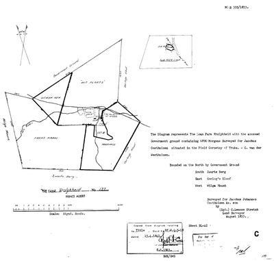 Surveyor-General diagram, B355/1833, August 1833
SCAN484.TIF
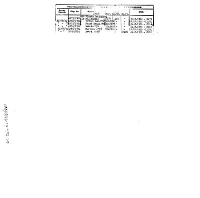 Diagram verso, B355/1833 (verso), August 1833
SCAN485.TIF
death-notice-8586-1846-charles-frederik-hitge.jpg
Cadastre
Surveyor-General diagram index for this parcel
Research notes
original Marincowitz farm; Ger(H)olm d.1890 [29 Jul 2026] A third portion (Faans Kraal, PAR-000034) also cites the 1841 N. HitgeM title rather than this farm's own 1841 Oosthuisen grant as its antecedent - see DOC-0068/DOC-0069/DOC-0072. Neighbour Oorlogs Kloof (farm No.172, east boundary) confirmed via its own 1833 diagram, DOC-0073 - now tracked as PAR-000066 (29 Jul 2026). [29 Jul 2026] A different, unrelated farm also called Vrolykheid (No. 61, Tulbagh, DOC-0074) surfaced in the inbox - the Oosthuizen family is independently documented living at Tulbagh for two generations before the Koup (PER-000230, PER-000118). See LEAD-0010: whether this farm was named for that one, by memory rather than any land connection - not asserted, not settled.
[1 Aug 2026, re-read of DOC-0068 and DOC-0072] FIELD CORNETCY = KREDOUW. On BOTH 1934 Melville diagrams the printed line reads 'situate in the Field Cornetcy of' with TRAKA STRUCK OUT AND KREDOUW WRITTEN IN, in the surveyor's hand. Two independent sheets, the same deliberate correction. So this ground sat in the KREDOUW ward of the Prince Albert division, not the Traka ward - and that is the answer to where 'aan Kriedouw' in the 1821 Beaufort West baptisms points. See LEAD-0052.
[6 Aug 2026, SRC-294] [FAMILY] A HOUSEHOLD ON THIS GROUND IN 1809, twenty-four years before Stretch measured it. Fred van Zyl states that Ockert Jacobus OosthuizenL (PER-000211) was born on Vrolikheid in 1809, which places his father Jacobus Johannes - the man the 1833 diagram was surveyed for - here a full generation earlier. This project's documented occupation of the farm starts with that survey; if the 1809 birth holds, the occupation starts with a loan-farm household nobody has yet found a paper for. It is testimony, not a document, and the 1809 baptism entry would name the farm and settle it. [TO VERIFY] LEAD-0110.
*** [23 Aug 2026] CUT ON PAPER, NEVER SPLIT ON THE GROUND. Frans, when the held-together flag surfaced this group: 'vrolikhyd might have been cut, but never split.' The documents say he is right. ***
VINCENT CHARLES MARINCOWITZ (PER-000045, 1877-1950) HELD ALL FOUR PORTIONS: Wit Plaats Ptn 1 from 30 Sept 1922 (deed 8479, diagram 4275/1921); Uitkyk Nek Ptn 2 AND Marinco Ptn 3 on the SAME DAY, 18 December 1935, ON THE SAME DEED 11074; and Faans Kraal Ptn 4 on 24 August 1936 (deed 8110).
THE SURVEYS GIVE IT AWAY. Portions 2, 3 and 4 were all framed in JULY 1934 and carry consecutive diagram numbers - 4932/1934, 4933/1934 and 4935/1934. One survey campaign, one farm, one man. The subdivision was a cadastral act and not a division of occupation.
AND HE DIED ON IT: 6 February 1950, on Vrolikheid (SRC-008).
TWO PORTIONS ON ONE DEED IS THE CLINCHER, because the cadastre itself treated 2 and 3 as a single transaction. The subdivision rule still gives each portion its own page and its own history, which is right - what this note records is that on the ground they were one farm.
[16 Sep 2026] WHAT THE WORD MEANT TO THE PEOPLE WHO USED IT. George Thompson, at a wedding ball of a corn and wine farmer near Cape Town in 1822, wrote that the guests 'continued their vrolykheid (as they call it) without intermission till morning' (SRC-635, vol. II p. 120). So in this family's own generation the everyday sense was merrymaking and festivity, which sits alongside the dictionary sense of cheerfulness S012 gives. It says nothing about who named this farm or why; that question is LEAD-0010.
The research behind this page, kept separate from it: dated working notes, open questions, and what is not yet settled.
Open questions
-
Who was Petrus Oosthuizen of Klaarstroom, and how is he related?
priority 1 · LEAD-0029
The village at the centre of this project's anchor was laid out on his land in 1858-60 and originally named Petersburg for him. He is not in the model's family. Where does he sit, and is he a descendant of Ockert Almero and Adriana Cecilia?
What would settle it The death notice - it names parents, spouses and surviving children.
-
Which congregation baptised Jan de Bruijn in 1769?
priority 1 · LEAD-0030
The register page (SRC-168) gives the entry in full but not the church. If it is Roodezand/Tulbagh, the de Bruin family is a Tulbagh family and the Vrolykheid name-transfer of LEAD-0010 has a documented carrier. If it is Drakenstein or Swellendam, it does not.
What would settle it The waypoint. This is a thirty-second lookup, not a research task.
-
Nicolaus Hitge's will and estate account, 1848 - does it hold Wit Plaats?
priority 1 · LEAD-0097
Is the 'N. HitgeM' granted Wit Plaats on 15 April 1841 the Uitenhage shopkeeper Nicolaus HitgeM (1785-1848)?
What would settle it The estate account lists the immoveable property. If Wit Plaats or Vrolykheid appears in it, PER-000044 is PER-000328 and the row can be merged. If the estate holds only Uitenhage property, the 1841 grantee is a different Hitge and the search moves to the 1841 deed itself. Now with a specific thing to look for: DOES THE ESTATE LIST SANDFONTEIN, WIT PLAATS, OR BOTH? If Sandfontein only, close this lead in the negative and the search moves to the 1841 deed and to the OTHER Hitge men - his sons Conrad Anthony and George Joseph Roy were adults by then.
-
Was a van Zyl household living on Middelwater in 1839, and was Jacobus Johannes on Vrolikheid in 1809?
priority 1 · LEAD-0110
Fred van Zyl states that his great-grandfather Jan Adriaan van Zyl was born on Middelwater on 9 November 1839, and that Ockert Jacobus OosthuizenL was born on Vrolikheid in 1809. Both would put named households on this project's core ground a generation earlier than its documents do.
What would settle it The two baptism entries. Each names the farm and the parents in the same line.
-
Were the three farms of the 1833 survey season taken up by three brothers?
priority 1 · LEAD-0215
Middelwater was surveyed for "Okert Oosthuizen" (PER-000054), Vrolykheid for "Jacobus Johannes OosthuizenL As. son" (PER-000043), and De Claar Stroom between them belonged to "Petrus Oosthuizen" (PER-000505). Are these three men Ockert Almero (PER-000001), Jacobus Johannes (PER-000208) and Pieter Marthinus (PER-000146), three of the eighteen children of Ockert Jacobus OosthuizenL (PER-000118)?
What would settle it A deed or a register naming any one of the three with a patronymic or a father, on the farm. Failing that, an estate file for Pieter Marthinus that names De Claar Stroom.
-
Who held De Claar Stroom between 1777 and 1833, and why did the Oosthuizens come to this ground?
priority 1 · LEAD-0216
The loan farm De Claar Stroom was granted in 1777 and ran from Middelwater to Vrolikheid. No holder is recorded for it before Petrus Oosthuizen in 1858. Who had it in between, and is there a tie between that household and the Oosthuizens of the Olifants River that would explain why they came to exactly this ground rather than anywhere else in the Karoo?
What would settle it A named holder of De Claar Stroom in the 1810s, and any tie of marriage, witnessing or trade between that household and the Oosthuizens before 1818.
-
N. Hitge's true footprint on Vrolykheid - and his relationship to Frans's own Hitge ancestors
priority 2 · LEAD-0009
Did N. HitgeM's 1841 title (B.W.Q.5.18) actually cover more of Vrolykheid than the ~2,177-morgen Wit Plaats portion recorded for him - and how is N. HitgeM (PER-000044) related to Aletta Catharina Maria Helena HitgeM (PER-000139, Frans's own direct 2x-great-grandmother) and to Hester Carolina Adriana HitgeM (PER-000178, who married into the Marincowitz line)?
What would settle it A record giving N. HitgeM's full given name and naming his children, matched against Aletta Catharina Maria Helena HitgeM (b.1846) and Hester Carolina Adriana HitgeM (b.1826) - if both are his daughters, or one his daughter and the other a niece or cousin, that settles the family relationship and gives a documented reason one 1841 title could legitimately be cited across multiple later Vrolykheid portions, subdivided within the Hitge family before ever reaching Marincowitz hands
-
Is the Koup's Vrolykheid named for the Tulbagh farm of the same name?
priority 2 · LEAD-0010
Jacobus OosthuizenL (PER-000230) and Dina Carolina BritzM raised their family at Tulbagh from 1749 into the 1770s-80s, including Ockert (PER-000118, b.1755), the root ancestor's own father. A different, independently surveyed farm called Vrolykheid (No. 61, in the Kom van Tulbagh, erfpacht loan-place of T.G. HugoM, surveyed 1816) sits in exactly that district. Is the Koup's Vrolykheid (PAR-000014, granted 1841 to an unidentified Jacobus Johannes OosthuisenM, 'Andries son') named after this Tulbagh farm, carried as a remembered place-name rather than any documented land connection?
What would settle it Any document naming Vrolykheid, Middelwater or De Claar Stroom BEFORE 1818 - a loan-farm rent roll, an opgaafrol, a Council of Policy resolution. That decides the whole question in one line: a name in use before the family arrived cannot have travelled with them. | A document placing the Oosthuizen family (or specifically PER-000043's own branch) at or near the Tulbagh Vrolykheid, or naming the Koup farm's origin explicitly; short of that this stays a plausible but unproven toponymic-transfer hypothesis, the same kind this project has already tested once for the surname Oosthuizen itself (SRC-103)
-
Where exactly is Vischat / 'fisgat', and what is its real name?
priority 2 · LEAD-0018
Vischat is where Frans's grandfather Hendrik Lodewyk Malherbe OosthuizenM farmed until 1979 and where his father CJJ grew up, yet the model has no ground for it: no extent, no geometry, no ownership row, no document. Which parcel does it actually sit on, and is the name Vischgat/Visgat?
What would settle it The purchase deed - it will name the parcel Vischat forms part of. Failing that, a topo sheet showing the werf, or CJJ simply saying which farm it was on.
-
Two households widowed 24 hours apart, July 1846 - one event or two?
priority 2 · LEAD-0102
Charles Frederick HitgeL died 29 July 1846 and Anna Magdalena StrijdomH died the very next day. Both survivors remarried within the year, a married couple also died that year, and 1846 ties as the heaviest pre-1890 death year in this record. Was there a mortality event in the district that July?
What would settle it A cause of death on either notice, or a visible excess of burials in the register for those months.
-
Fourteen children of Ockert Jacobus Oosthuizen (b.1809) are missing from this model
priority 2 · LEAD-0109
Fred van Zyl states that PER-000211, born on Vrolikheid in 1809 and the man who named the Marico Klaarstroom, had fourteen children - one of them Susara Cornelia Oosthuizen, who married Fred's great-grandfather Jan Adriaan van Zyl. This model records none of them. Who were they?
What would settle it A register or the descendant compilation Fred already holds. Susara Cornelia is the one to start with, because her marriage to Jan Adriaan van Zyl dates and places the family.
-
A 1907 petition names James Caithness Marincowitz of Vrolykheid, suing his wife for restitution of conjugal rights
priority 2 · LEAD-0185
NAAIRS (supplied by Frans in chat indexes a Cape Supreme Court motion: PETITION OF JAMES CAITHNESS MARINCOWITZ OF VROLYKHEID, DIVISION OF PRINCE ALBERT, FOR LEAVE TO SUE HIS WIFE JOHANNA DOROTHEA CORNELIA ELIZABETH COETZEE BY EDICTAL CITATION FOR RESTITUTION OF CONJUGAL RIGHTS. Is the petitioner PER-000195 (b. 18 Jun 1866, d. 1934), and what does the file say about the household on Vrolikheid in 1907?
What would settle it The CSC file itself. It will name the marriage date and place, the desertion account, and where she was thought to be - household detail for Vrolikheid in 1907 that no farm paper carries.
-
De Claar Stroom: one parcel or two?
priority 3 · LEAD-0039
PAR-000004 is the 1777 loan farm De Claar Stroom and PAR-000097 is cadastral farm 178, the ground Klaarstroom village stands on. Should they be one parcel row or two?
What would settle it The extent on the 178 title, compared with the loan farm's described run. If they are the same ground, one row; if 178 is a part, two.
-
What does 'As. son' on the 1963 copy of the Vrolykheid diagram actually say, and which deed was the 1841 title?
priority 3 · LEAD-0354
Diagram B355/1833 as typed in 1963 reads 'Surveyed for Jacobus Johannes OosthuizenL As. son' and cites deed 'Bf.W.Q.5-1B'. The man is now identified as Ockert's son (LEAD-0213). Is 'As.' a typist's misreading of the 1833 hand, and is '5-1B' really 5-18, the Hitge deed?
What would settle it Sight of the 1833 manuscript or the 1841 title deed.
-
Two parcel_links rows share the id PLK-000019
priority P2 · LEAD-0312
Two different subdivisions carry one link id. Which row keeps PLK-000019, and which is renumbered?
What would settle it Frans's call on which keeps the id. NOT fixed silently: 3 says ids are permanent, so renumbering somebody else's row is a decision, not a tidy-up.
What the record is missing
-
The record stops in 1890 and never resumes
second order · B2 trail-ends
Vrolikheid was worked as far as 1890-05-13, with Ger(H)olm Marincowitz the last owner on record. 136 years follow with nothing. Who held it after that, and is it still one farm?
What would settle it The current title deed traced backwards, each transfer names the one before it, or the Surveyor-General's subdivision diagrams, which are what usually explain a farm going quiet.
Found by breaks.py reading the model against itself, not written by hand,
each one is a shape of missing record, not a fault in the data.
The whole set is on the
questions page.