Wilgemond No. 179
179 on the cadastre · on record 1833–1841 · show on the map
- Farm number
- No. 179
- On the cadastre
- 179, whole farmregistered as WILGEMOND
- District
- Prince Albert
- Extent, as the diagram states it
- 4503 morgen 125 roods
- Modern surveyed area
- 3285.6 ha
The historic extent and the modern surveyed area are two separate measurements and are not presented here as confirming each other. The first is what a surveyor wrote on a diagram, usually in morgen. The second is what the modern cadastre draws.
Why this farm is here
Martinus van Veuren (Wilgamount, 1833) held it, and no kinship to the Oosthuizen, Marincowitz or Van der Merwe lines is recorded, this ground entered through the land, not the family. 4 km from Klaarstroom.
- story A written history names this ground On 15 April 1841 loan ground becomes property
- story A written history names this ground The men who drew the boundary lines
- story A written history is set on this ground The van Vuurens of Wilgemond
- border Shares a boundary with Vrolikheid Vrolikheid
- …and 2 more, listed in full further down this page.
Stories
- mentions this farm
On 15 April 1841 loan ground becomes property
One surveyor works the Koup for two seasons. Seven years later, on a single day, the Crown converts the loan farms to perpetual quitrent: twenty-one deeds on twenty parcels, and the map of the district is set for a century.
- mentions this farm
The men who drew the boundary lines
Every farm here passes through two officials: a veldkornet who knew the ground, and a surveyor paid by the sheet. Forty-two surveyor signatures over 172 years, a century of ward officers, and a ward boundary changing by hand on a 1934 diagram. The first surveyor, C. Lennox Stretch, was later dismissed for taking the Xhosa side.
- about this farm
The van Vuurens of Wilgemond
Wilgemond No. 179 was surveyed in 1833 for a "Martinus van Veuren" and granted in 1841 to a "J.M.J. van Vuuren" - two sets of initials on Vrolikheid's western boundary. Four documents later they are a family, and on 22 December 1838 one of them married an Oosthuizen.
What the record holds, in order
-
August 1833
document
SG diagram 150/1833
Bf.W. 5-9
- August 1833 document SG diagram verso 150/1833 (verso)
-
before 1833
ownership
Martinus van Veuren (Wilgamount, 1833)
loan farm · survey · confidence high
-
15 April 1841
ownership
J.M.J. van Vuuren (Wilgemond, 1841)
Perpetual Quitrent · grant · confidence high
Bordered by, as the diagram names them
- N The Ape (Government ground)
- S Zwarte Berg
- E Vrolikheid
- E Klaarwater
On the 1915 divisional map
As the Surveyor-General printed this farm in 1915: the registered holder, the date the title was issued and its quitrent reference, copied off the sheet as written. The whole map, farm by farm
| Farm, as printed | Holder | Title | Quitrent | Note |
|---|---|---|---|---|
| WILGEMOND | J. M. J. v. Vuuren | 16 April 1841 | B.W.Q. 5.9 · fol. 956 | The map prints 16 April; OWN-000075 has 15 April 1841, the grant day. LEAD-0349. |
Also bordered by, as the modern cadastre draws it
Ground that touches this farm on the Surveyor-General's current polygons and that none of the diagrams held here names. Derived from the geometry, not read off a document.
- N Middelwater
- NE De Claar Stroom (Klaarstroom No. 178)
- E Faans Kraal (Vrolikheid No. 177 Ptn 4)
- SE Witberg No. 180
- W Groote Leegte (Klein Valie No. 182 Ptn 5)
- W Drie Punt No. 181
- NW Avondrust (Middelwater No. 169 Ptn 6)
- NW Groenkraal (Klein Valie No. 182 Ptn 7)
Documents
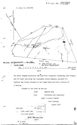 Surveyor-General diagram, 150/1833, August 1833
10TVT501.jpg
 Diagram verso, 150/1833 (verso), August 1833
10TVT901.jpg
Cadastre
Surveyor-General diagram index for this parcel
Research notes
[31 Jul 2026 inbox] VROLIKHEID'S WESTERN NEIGHBOUR - the 1833 diagram is bounded 'East by Vrolikheid and Klaarwater'. Loan farm Wilgamount, surveyed Aug 1833 by C. Lennox Stretch for Martinus van VeurenH, granted 15 Apr 1841 to J.M.J. van VuurenH on quitrent Bf.W. 5-9 (DOC-0117). The 1833 extent converts to 3,857 ha against a modern 3,286.8 - the difference is roughly Portion 2's 840.6 morgen, cut off in 1952. Recorded, not reconciled.
The research behind this page, kept separate from it: dated working notes, open questions, and what is not yet settled.
Open questions
-
Is Minnies Kraal No. 112 named for the MINNE family - who married into the Janse van Vuuren of Wilgemond?
priority 1 · LEAD-0071
Does the farm name Minnies Kraal come from the Mienie/Minnie surname, and if so which member of that family held or occupied the ground?
What would settle it A grant, quitrent or early diagram of farm 112 naming a MINNE as occupier or grantee - the spelling on the document is itself part of the answer. Failing that, a Minne recorded on or beside that ground before the name appears on a map.
-
Wilgemond's diagram number: 150/1833, or 350 mis-transcribed in 1952?
priority 2 · LEAD-0025
Every other farm in Stretch's August 1833 run carries a diagram number between 348 and 369, and their quitrent folios rise with them. Wilgemond is numbered 150/1833 yet holds folio 5-9, which falls exactly inside that run. Is the number wrong?
What would settle it The original diagram, or the SG's index of 1833 Prince Albert diagrams.
-
"[?Hoeagus]" is HAGGAS No. 145 - RESOLVED by the widow's own death notice
priority 2 · LEAD-0072
What is the place written as the residence in field 8 of death notice No. 682 of 1863, and where is it?
What would settle it A clearer image of field 8, or the estate inventory naming where his stock and ground lay.
-
Who was 'The Ape', and who ended up with it?
priority 3 · LEAD-0026
Both the Wilgemond and Klein Valie surveys of 1833 annex a piece of Government ground called THE APE, and Wilgemond is bounded on the north by it. What is it, where is it, and is the name Die Aap?
What would settle it Any map or deed naming it.
-
Four farms where the 1915 divisional map and this record give a different title date
priority 3 · LEAD-0349
The 1915 divisional map prints a title date and quitrent number on every farm. On four farms this project already holds, it disagrees with the record: which is right? (1) HAGAS No. 145: the map prints B.W.Q. 5.31 to J.M.J. v. Vuuren and another, dated 24 October 1842; DOC-0131 carries Bf.W.Q.5-31 with a title date of 15 April 1841. (2) WILGER FONTEIN: the map prints 17th May 1878 against P.A.Q. 2.11; DOC-0352 and OWN-000119 read the same title as 17 May 1875. (3) WILGEMOND: the map prints 16 April 1841 against B.W.Q. 5.9; OWN-000075 has 15 April 1841, the grant day. (4) KLIPGAT: the map prints an amended title to the estate of the late L.D.F. v. Zyl as 9.9.191[?1]; OWN-000088 and DOC-0158 have 24 September 1911, P.A.Q. 6-7.
What would settle it The date written on the quitrent title itself, which both the map and the diagrams copied.
What the record is missing
-
The record stops in 1841 and never resumes
second order · B2 trail-ends
Wilgemond No. 179 was worked as far as 1841-04-15, with J.M.J. van VuurenH (Wilgemond, 1841) the last owner on record. 185 years follow with nothing. Who held it after that, and is it still one farm?
What would settle it The current title deed traced backwards, each transfer names the one before it, or the Surveyor-General's subdivision diagrams, which are what usually explain a farm going quiet.
-
“Klaar Water” is named as a neighbour 2 times and we hold no parcel for it
third order · B3 unheld-farm
2 separate surveys in this model put Klaar Water on the boundary of ground we do hold (PAR-000001, PAR-000087). It has no parcel of its own here, so nothing is known about who held it or when, while it borders farms at the centre of the project.
What would settle it The Surveyor-General's farm index for the registration division will give it a farm number and a diagram; the cadastre pull in `fetch_cadastre.py` then places it on the map.
Found by breaks.py reading the model against itself, not written by hand,
each one is a shape of missing record, not a fault in the data.
The whole set is on the
questions page.