Witberg No. 180
180 on the cadastre · on record 1913 · show on the map
- Farm number
- No. 180
- On the cadastre
- 180, whole farmregistered as WITBERG
- District
- Prince Albert
- Extent, as the diagram states it
- 7011 morgen 210 square roods
- Modern surveyed area
- 3622.5 ha
The historic extent and the modern surveyed area are two separate measurements and are not presented here as confirming each other. The first is what a surveyor wrote on a diagram, usually in morgen. The second is what the modern cadastre draws.
Why this farm is here
Here because an open question in this record is about it; who held it is not yet established. 7 km from Klaarstroom.
- border Shares a boundary with Vrolikheid Vrolikheid
- border Shares a boundary with Faans Kraal (Vrolikheid No. 177 Ptn 4) Faans Kraal (Vrolikheid No. 177 Ptn 4)
- border Shares a boundary with Oorlogs Kloof No. 172 (Roode Els Bosch and Oorlogs Kloof) Oorlogs Kloof No. 172 (Roode Els Bosch and Oorlogs Kloof)
- border Shares a boundary with Wilgemond No. 179 Wilgemond No. 179
- …and 2 more, listed in full further down this page.
What the record holds, in order
- March 1913 document SG diagram 1016/1913
Bordered by, as the diagram names them
- N Wilgemond
- N Vrolykheid
- N Roode Els Bosch
- NE Hagas
- S Blaauw Punt, Erin, Zwart Berg and Blesberg
- W Crown Land
- SE Crown Land
On the 1915 divisional map
As the Surveyor-General printed this farm in 1915: the registered holder, the date the title was issued and its quitrent reference, copied off the sheet as written. The whole map, farm by farm
| Farm, as printed | Holder | Title | Quitrent | Note |
|---|---|---|---|---|
| WITBERG Forest | G.N. 334 1911 · fol. 6615 | Plan 2922 91 printed beside it |
Also bordered by, as the modern cadastre draws it
Ground that touches this farm on the Surveyor-General's current polygons and that none of the diagrams held here names. Derived from the geometry, not read off a document.
- NE Faans Kraal (Vrolikheid No. 177 Ptn 4)
- NE Marinco (Vrolikheid No. 177 Ptn 3)
- E De Vlei No. 176
- W Drie Punt No. 181
- W Uitkyk No. 12 (Oudtshoorn)
- W Blaauwpunt No. 13 (Oudtshoorn)
Documents
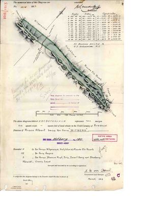 Surveyor-General diagram, 1016/1913, March 1913
10701801.PDF
Cadastre
Surveyor-General diagram index for this parcel
Research notes
[31 Jul 2026 inbox] The Zwartberg ground on the southern boundary of Vrolikheid AND of Roode Els Bosch (PAR-000066) - the 1913 diagram names both, with Wilgemond, as its northern neighbours (DOC-0123). Surveyed March 1913 by K.M. von OppellM in the field cornetcy of Kredouw, beacons pointed out by C.J. SchoemanM F.C. Annotated 'Reserved for Forest purposes' on 21 January 1915, so it went out of farming into the Swartberg reserve within two years of being surveyed. The sheet's own metric stamp reads 6005.4457 ha; the modern cadastre gives 4,351.3 for the farm and 3,623.7 on the portions layer, so ground has left it since. Not reconciled.
The research behind this page, kept separate from it: dated working notes, open questions, and what is not yet settled.
Open questions
-
Six parcels whose surveyed extent is far from their polygon with no reason recorded
priority 2 · LEAD-0093
For each, is the extent mistyped, or did ground leave the farm without a note?
What would settle it The deduction table. It lists portion, name, extent, diagram and deed on one line.
What the record is missing
-
Nobody is on record as ever having held this
third order · B8 never-held
Witberg No. 180 is in the model and drawn on the map, and carries no ownership record of any kind, not a grant, not a transfer, not an occupation.
What would settle it The Surveyor-General's diagram for the farm number names the grantee and the date; the deed reference on it opens the transfer chain.
Found by breaks.py reading the model against itself, not written by hand,
each one is a shape of missing record, not a fault in the data.
The whole set is on the
questions page.