Oorlogs Kloof No. 172 (Roode Els Bosch and Oorlogs Kloof)
172 on the cadastre · on record 1833–2005 · show on the map
- Farm number
- No. 172
- On the cadastre
- 172, whole farmregistered as OORLOGS KLOOF
- District
- Prince Albert
- Extent, as the diagram states it
- 16124 morgen 490 sq roods
- Modern surveyed area
- 5766.4 ha
The historic extent and the modern surveyed area are two separate measurements and are not presented here as confirming each other. The first is what a surveyor wrote on a diagram, usually in morgen. The second is what the modern cadastre draws.
Why this farm is here
Charles Frederick Hitge lived on this ground, a blood relative of the Oosthuizen, Marincowitz or Van der Merwe lines, 2 steps away. 13 km from Klaarstroom.
- Charles Frederick Hitge
- parent of Aletta Catharina Maria Helena Hitge
- parent of Almero Jacobus Hitge Oosthuizen
Each step is a recorded parentage or marriage in this model, and the shortest one the record supports, follow the names to check it.
- story A written history names this ground Vrolykheid's story
- story A written history names this ground Middelwater's story since 1777
- story A written history names this ground On 15 April 1841 loan ground becomes property
- parcel Consolidated into: Oorlogs Kloof No. 175 (1940 consolidation)
- …and 2 more, listed in full further down this page.
Stories
- mentions this farm
Vrolykheid's story
The farm where the paper and the people disagree: Stretch's 1833 survey already carrying the names of portions not cut for another century, two titles granted on one day in 1841 - one to an Oosthuisen and one to an 'N. Hitge' whose deed four later portions cite instead - a Trieste immigrant who married a Hitge in 1844 and died holding the farm in 1890, and the death notice that finally put the Hitges on the ground.
- mentions this farm
Middelwater's story since 1777
From a loan farm on the Zwartberg to eight cadastral parcels: the full documented history of Middelwater No. 169 - Stretch's 1833 survey for Okert Oosthuizen, the twelve-farm grant day of 1841, the 1883 resurvey and the 1884 quitrent to J.D.J. Oosthuysen 'and another', the portions cut off for a spring called Vaste Water and a place called Avondrust, and the 1990 power-line survey whose coordinates finally put the farm on a map.
- mentions this farm
On 15 April 1841 loan ground becomes property
One surveyor works the Koup for two seasons. Seven years later, on a single day, the Crown converts the loan farms to perpetual quitrent: twenty-one deeds on twenty parcels, and the map of the district is set for a century.
What the record holds, in order
-
August 1833
document
SG diagram 356/1833
BF.WQ 5-30
-
1833~ to 1863
ownership
Lucas van Veuren ("P. Zoon")
loan farm · survey · confidence high
-
29 July 1846
event
Charles Frederick Hitge (about 1818-07–29 July 1846), Sophia Johanna Mocke (14 January 1820–3 December 1885), Aletta Catharina Maria Helena Hitge (11 June 1846–25 July 1933)
A farmer of 27, born in England, dies on Vrolykheid in the Zwartberg leaving moveable property and one child seven weeks old and not yet baptised. [CORRECTED 30 Jul 2026] This row previously read "dies at Oorlogs Kloof (PAR-000066)" on the family tree's authority, marked [TO VERIFY against a death notice or register]. That verification has now happened and it went the other way: death notice no. 8586 (DOC-0110), signed by his brother and filed within five weeks, gives the place as "Vrolykheid Zwarteberg". Oorlogs Kloof is a different farm, not a variant name. The 1841 N. Hitge title over Vrolykheid is five years earlier - see LEAD-0009. NOTE: EVT-000179 was briefly allocated to a duplicate of this event on 30 Jul 2026 and merged in here; that id is retired and must not be reused.
-
29 July 1846
lived here
Charles Frederick Hitge (about 1818-07–29 July 1846)
died there · to 1846-07-29
-
December 1863
document
SG diagram B.685/1872
P.A.Q.1-31
-
1872-11-30 to 1941-04-16
ownership
owner not named in the record
quitrent · amended title · confidence high
- August 1938 boundary change consolidation: becomes Klipfontein A No. 174
- 1940 boundary change consolidation: becomes Oorlogs Kloof No. 175 (1940 consolidation)
-
2004
burial
Johannes Rudolph Alheit
Oorlogs Kloof / Roode Elsie 172 farm cemetery
-
2005
burial
Henriette Grace Van Wyk
Oorlogs Kloof / Roode Elsie 172 farm cemetery
- undated document SG diagram verso B.685/1872 (verso)
Bordered by, as the diagram names them
- north Witte Klip
- south Zwarte Berg
- south Haggis
- east Kloofs Plaats
- east Government Ground
- west Vrolykheid
- north Klip Fontein
- north Kloof Plaats
- north Government Land
- east Haggis
- east Government Land
On the 1915 divisional map
As the Surveyor-General printed this farm in 1915: the registered holder, the date the title was issued and its quitrent reference, copied off the sheet as written. The whole map, farm by farm
| Farm, as printed | Holder | Title | Quitrent | Note |
|---|---|---|---|---|
| ROODE ELS BOSCH AND OORLOGS KLOOF Amended Title | J. Marincowitz & another | 30 November 1872 | P.A.Q. 1.37 · fol. 977 |
Buried on this ground
- Oorlogs Kloof / Roode Elsie 172 farm cemetery 2 graves recorded
The burials also appear on this farm's timeline above, each at its own date.
Also bordered by, as the modern cadastre draws it
Ground that touches this farm on the Surveyor-General's current polygons and that none of the diagrams held here names. Derived from the geometry, not read off a document.
- N Klein Elandsfontein (Rondabel No. 124 Ptn 7)
- NE Klipfontein A No. 174
- NE Klipfontein A No. 174 Remainder
- E Oorlogs Kloof No. 175 (1940 consolidation)
- SE De Vlei No. 176
- W Wit Plaats (Vrolikheid No. 177 Ptn 1)
- W Marinco (Vrolikheid No. 177 Ptn 3)
- W Witberg No. 180
- W De Claar Stroom (Klaarstroom No. 178)
- NW Rondabel
- NW Die Kruine No. 170
Documents
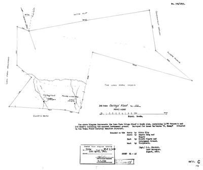 Surveyor-General diagram, 356/1833, August 1833
SCAN538.TIF
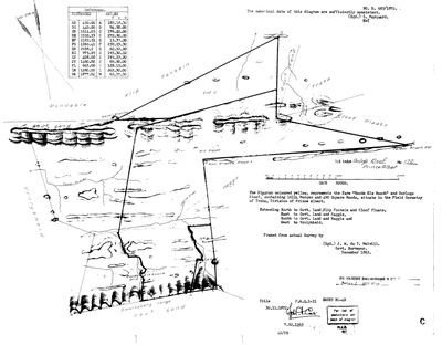 Surveyor-General diagram, B.685/1872, December 1863
SCAN536.TIF
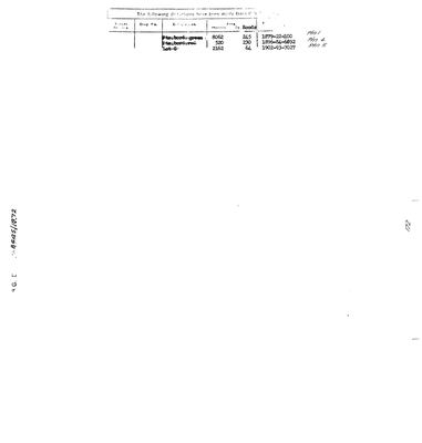 Diagram verso, B.685/1872 (verso)
SCAN537.TIF
Cadastre
Surveyor-General diagram index for this parcel
Research notes
Vrolykheid's EASTERN BOUNDARY NEIGHBOUR, named on DOC-0027/0068/0072 and confirmed by its own diagrams. 1833: loan farm "Orlogs Kloof & Roode wilde else", 14,780mg 150sr, surveyed for Lucas Van Veuren, title 15.4.1841 deed BF.WQ 5-30 (DOC-0073 - the same 15 April 1841 grant batch as Vrolykheid, Middelwater, Rondabel and Wolwekraal). 1863/1872: resurveyed as "Roode Els Bosch and Oorlogs Kloof", 16,124mg 490sr, title 30.11.1872 P.A.Q.1-31 (DOC-0078); extent_text carries the 1872 figure. Deductions per DOC-0079: Ptn 1 (8062mg, 1879), Ptn 4 (520mg, 1896), Lot C/Ptn 5 (2162mg, 1902). The historic farm covered what is now farms 172, 173 (Annex) and 175; the cadastre match here is the modern farm 172 core (5,767.7 ha), so sg_area_ha and extent_text deliberately do not reconcile. HITGE CONNECTION (the reason this farm is tracked): Charles Frederick HitgeL (PER-000327), father of direct ancestor Aletta (PER-000139), died here 29 Jul 1846 per the family tree - see EVT-000166 and LEAD-0009.
[1 Aug 2026] *** GEOMETRY CORRECTED - IT WAS POINTING AT THE WRONG POLYGON. *** Frans, looking at the map: "this farm in middle still missing". There was a gap between Vrolikheid and Oorlogs Kloof where both 1833 and 1863 diagrams say the two farms TOUCH. THE CADASTRE CARRIES TWO FEATURES NUMBERED 172 IN PRINCE ALBERT: W052C061000000000172000000, 5,767.7 ha, centroid (-33.363073, 22.690354) - immediately east of Vrolykheid; and E107C061000000000172000000, 1,420.3 ha, centroid (-33.316536, 22.800276) - about 11 km further east. THIS ROW HAD THE E107 KEY AND THE E107 CENTROID while its own notes already said the intended match was 'the modern farm 172 core (5,767.7 ha)' - which is W052's area. The row contradicted itself and the map drew the contradiction. Corrected to W052. Confirmed three ways: the two diagrams both put Vrolykheid on the west; the official CSG viewer shows RE/172 abutting 1/177 Vrolykheid; and 5,767.7 ha is the figure this row already carried in prose. PREVIOUS VALUES, recorded rather than overwritten silently: centroid ('-33.321140', '22.808332'), sg_area_ha 1420.3, key E107C061000000000172000000. SAME CLASS OF BUG AS HAGGAS: a farm number that repeats, matched on the number. 9 warns about exactly this and it has now happened twice.
[1 Aug 2026, history written up] OORLOGS KLOOF No. 172, later 'Roode Els Bosch and Oorlogs Kloof'. In the Traka field cornetcy, on the north side of the Zwartberg, with Vrolykheid on its west and Haggas on its south and east. THE CHAIN, from the three diagrams held here. 1833: Stretch surveys the loan farm 'Orlogs Kloof & Roode wilde else', 14,780 morgen 150 roods including annexed Government ground, FOR LUCAS VAN VEUREN, entered on the form as "P. Zoon" (DOC-0073). 15 April 1841: titled Bf.W.Q.5-30, one of the batch of titles issued across this district on that single day, alongside Reim Hoogte, the Hitge title, Haggas and Uitnood. December 1863: Melvill resurveys it at 16,124 morgen 490 square roods and it is retitled P.A.Q.1-31 on 30 November 1872 (DOC-0078). Then it comes apart: Portion 1 of 8,062 mg 245 sr in 1879, Portion 4 of 520 mg 230 sr in 1896, Lot C of 2,162 mg 64 sr in 1902 (DOC-0079). AND THEN THE STATE BUYS IT BACK. In January 1940 four surviving pieces are surveyed together as OORLOGS KLOOF No. 175, 4,981.5038 morgen, and on 16 April 1941 a Certificate of Amended Title on Consolidation is issued IN FAVOUR OF THE GOVERNMENT OF THE UNION OF SOUTH AFRICA (DOC-0080). A farm granted out of Crown land in 1841 is back in Crown hands a century later, reassembled. Why is not on the diagram. LEAD-0062. WHY IT IS NOT PAINTED IN A FAMILY COLOUR ON THE MAP, since It is a VAN VEUREN farm that became a government one. Until 1 Aug 2026 it was worse than that - it carried no ownership record of any kind, so the map had no family to colour it with and drew it grey. That is now fixed; the grey was a gap in this collection, not a fact about the ground. THE NAME. Oorlogskloof is 'war's kloof'. THIS FARM'S OWN NAMING IS NOT DOCUMENTED in anything held here, and the honest position is that we do not know what war. Two things can be said. First, the name is OLDER THAN THE SURVEY: Stretch found it already called Orlogs Kloof in 1833, and it was a loan farm before that, so the name belongs to the occupation rather than to the paper. Second, and this is the trap: THERE IS A FAMOUS OORLOGSKLOOF AND IT IS NOT THIS ONE. The Oorlogskloof Nature Reserve near Nieuwoudtville in the Northern Cape is named for a commando action against a Khoi group under Captain Klipheuvel on 25 September 1739, and it is about five hundred kilometres from here. Attaching that battle to this farm would be exactly the namesake substitution 5 warns about. What CAN be said about this district is general and sourced: the northern slopes of the Swartberg saw sustained conflict between incoming trekboers and San through the middle of the eighteenth century, which is the period a loan farm here would have been taken up. A kloof named for a war on that frontier is entirely ordinary, and which war remains an open question. [TO VERIFY]
[SRC-319, 7 Aug 2026] A FARM CEMETERY IS RECORDED ON THIS GROUND BY eGGSA: 'Oorlogs Kloof and Roodeelse 172', Cemetery ID 7171, at -33.355817, 22.677167. Photographs and captions at https://graveswcape.eggsa.org/PRINCE-ALBERT-Rural/1121026%20Alheit%20grafte_Pieter%20Olckers/ - linked, not copied.
The research behind this page, kept separate from it: dated working notes, open questions, and what is not yet settled.
Open questions
-
match_cadastre.py no longer reproduces the geometry on disk
priority 1 · LEAD-0017
Re-running match_cadastre.py against the current CSVs changes 11 parcels and does not reproduce what is in parcels.csv. Which is right?
What would settle it Deciding per parcel whether the script's match or the hand entry is correct, then either fixing the script's name-matching or recording the hand values as deliberate.
-
N. Hitge's true footprint on Vrolykheid - and his relationship to Frans's own Hitge ancestors
priority 2 · LEAD-0009
Did N. HitgeM's 1841 title (B.W.Q.5.18) actually cover more of Vrolykheid than the ~2,177-morgen Wit Plaats portion recorded for him - and how is N. HitgeM (PER-000044) related to Aletta Catharina Maria Helena HitgeH (PER-000139, Frans's own direct 2x-great-grandmother) and to Hester Carolina Adriana HitgeM (PER-000178, who married into the Marincowitz line)?
What would settle it A record giving N. HitgeM's full given name and naming his children, matched against Aletta Catharina Maria Helena HitgeH (b.1846) and Hester Carolina Adriana HitgeM (b.1826) - if both are his daughters, or one his daughter and the other a niece or cousin, that settles the family relationship and gives a documented reason one 1841 title could legitimately be cited across multiple later Vrolykheid portions, subdivided within the Hitge family before ever reaching Marincowitz hands
-
Two Prince Albert parcels numbered 172, and a Haggas the cadastre extract cannot see
priority 2 · LEAD-0053
What is the 1,420 ha parcel also numbered 172 at (-33.3165, 22.8003), and where exactly is Haggas No. 145?
What would settle it A cadastre feature named Haggas with a PRCL_KEY, touching Oorlogs Kloof on its east or south.
-
Petrus van Veuren Senior and Lucas van Veuren "P. Zoon": father and son on adjoining ground?
priority 2 · LEAD-0054
Was Lucas van VeurenH of Oorlogs Kloof No. 172 the son of Petrus van Veuren SeniorM of Uitnood No. 147?
What would settle it A death notice or estate account naming Lucas as a son of Petrus, or a baptism entry giving Lucas a father Petrus. Either would turn an initial into a relationship.
-
Why did the State take Oorlogs Kloof in 1941?
priority 2 · LEAD-0062
What was the Government of the Union of South AfricaM consolidating Oorlogs Kloof No. 175 for in April 1941?
What would settle it The consolidation certificate itself names the purpose, or the Lands file does. Either turns a striking fact into a story.
-
Two households widowed 24 hours apart, July 1846 - one event or two?
priority 2 · LEAD-0102
Charles Frederick HitgeL died 29 July 1846 and Anna Magdalena StrijdomM died the very next day. Both survivors remarried within the year, a married couple also died that year, and 1846 ties as the heaviest pre-1890 death year in this record. Was there a mortality event in the district that July?
What would settle it A cause of death on either notice, or a visible excess of burials in the register for those months.
-
Is the Uitnood grantee kin to the van Vuuren mother buried beside him, and are the three August 1833 van Veurens one family?
priority 2 · LEAD-0197
C. Lennox Stretch surveyed three farms for three van Veurens in AUGUST 1833: Uitnood No. 147 for PETRUS VAN VEUREN SENIOR, Oorlogs Kloof No. 172 for LUCAS VAN VEUREN recorded as "P. Zoon", and Wilgamount for a MARTINUS VAN VEUREN. Are they one family, and is any of them kin to CATHARINA ADRIANA JANSE VAN VUUREN [PER-000605], whose two-year-old son lies in the Uitnood farm cemetery in 1842?
What would settle it One document naming a Petrus van Veuren and a Johannes Marthinus Janse van VuurenL in the same family - a death notice, an estate account, or a baptism where one witnesses for the other. Or a transfer of Uitnood to an heir this model can already name.
What the record is missing
-
39 years, and the ground changes hands to nobody we can follow
second order · B1 succession
On Oorlogs Kloof No. 172 (Roode Els Bosch and Oorlogs Kloof), Lucas van VeurenH ("P. Zoon") is the last owner recorded from 1833~, and the next entry is an unnamed holder from 1872-11-30, 39 years later, with no person in common. DOC-0078 records the later arrival but not the 39 years before it.
What would settle it The Deeds Office transfer register for this farm between 1833 and 1872. A transfer names its predecessor in title, so one deed closes the whole gap.
-
A tenure with no one in it
second order · B7 no-owner
OWN-000091 records a amended title on Oorlogs Kloof No. 172 (Roode Els Bosch and Oorlogs Kloof) from 1872-11-30 and names no party. Either the holder was never read off the document, or the publishing rule withheld them, the page cannot tell you which, and neither can this.
What would settle it Re-read DOC-0078.
-
The record stops in 1941 and never resumes
third order · B2 trail-ends
Oorlogs Kloof No. 172 (Roode Els Bosch and Oorlogs Kloof) was worked as far as 1941-04-16, with an unnamed holder the last owner on record. 85 years follow with nothing. Who held it after that, and is it still one farm?
What would settle it The current title deed traced backwards, each transfer names the one before it, or the Surveyor-General's subdivision diagrams, which are what usually explain a farm going quiet.
Found by breaks.py reading the model against itself, not written by hand,
each one is a shape of missing record, not a fault in the data.
The whole set is on the
questions page.