Oorlogs Kloof No. 175 (1940 consolidation)
175 on the cadastre · on record 1940–1941 · show on the map
- Farm number
- No. 175
- On the cadastre
- 175, whole farmregistered as OORLOGS KLOOF
- District
- Prince Albert
- Extent, as the diagram states it
- 4981.5038 morgen
- Modern surveyed area
- 4267.5 ha
The historic extent and the modern surveyed area are two separate measurements and are not presented here as confirming each other. The first is what a surveyor wrote on a diagram, usually in morgen. The second is what the modern cadastre draws.
Why this farm is here
Government of the Union of South Africa held it, and no kinship to the Oosthuizen, Marincowitz or Van der Merwe lines is recorded, this ground entered through the land, not the family. 18 km from Klaarstroom.
- parcel Consolidated out of Oorlogs Kloof No. 172 (Roode Els Bosch and Oorlogs Kloof)
- document A document in the collection describes this ground DOC-0080
- document A document in the collection describes this ground DOC-0081
- lead An open question in this record is about this ground Why did the State take Oorlogs Kloof in 1941?
What the record holds, in order
- 1940 boundary change consolidation: from Oorlogs Kloof No. 172 (Roode Els Bosch and Oorlogs Kloof)
-
January 1940
document
SG diagram 1177/1940
3262
-
16 April 1941
ownership
Government of the Union of South Africa
amended-title · confidence high
-
16 April 1941
ownership
owner not named in the record
freehold · consolidation · confidence high
- undated document SG diagram verso 1177/1940 (verso)
Also bordered by, as the modern cadastre draws it
Ground that touches this farm on the Surveyor-General's current polygons and that none of the diagrams held here names. Derived from the geometry, not read off a document.
- N Klipfontein A No. 174
- N Klipfontein A No. 174 Remainder
- NE Klipfontein Oost (Klipfontein A No. 174 Ptn 1)
- NE Onder Traka No. 144
- E Haggas No. 145
- E Karee Rivier No. 143
- S De Vlei No. 176
- W Oorlogs Kloof No. 172 (Roode Els Bosch and Oorlogs Kloof)
Documents
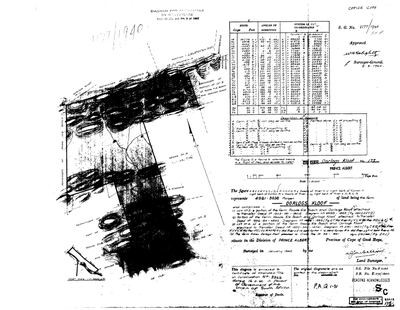 Surveyor-General diagram, 1177/1940, January 1940
10JS4901.TIF
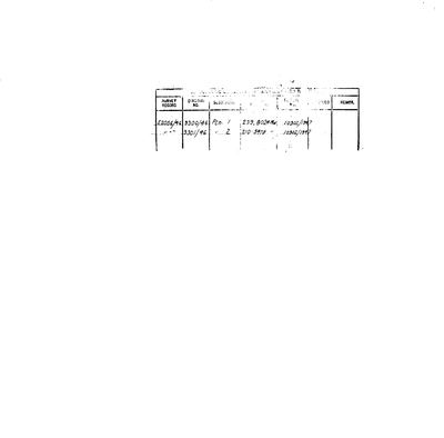 Diagram verso, 1177/1940 (verso)
10JS4801.TIF
Cadastre
Surveyor-General diagram index for this parcel
Research notes
Consolidated January 1940 out of Lots 3 and 4, a further portion, and Annex Oorlogs Kloof - all pieces of the old Roode Els Bosch and Oorlogs Kloof complex (PAR-000066) - and titled by Certificate of Amended Title on Consolidation No. 3262, 16 Apr 1941, IN FAVOUR OF THE GOVERNMENT OF THE UNION OF SOUTH AFRICA (DOC-0080). Verso deductions (DOC-0081): Ptn 1 (239.8024mg, dgm 9300/46, 10902/1947), Ptn 2 (210.5478mg, dgm 9301/46, 10902/1947) - matching the modern cadastre's 1/175 and 2/175. Modern farm-175 record measures 5,122.9 ha against the 1940 4,981.5mg = 4,267 ha; not reconciled, LEAD-0007 discipline applies.
The research behind this page, kept separate from it: dated working notes, open questions, and what is not yet settled.
Open questions
-
match_cadastre.py no longer reproduces the geometry on disk
priority 1 · LEAD-0017
Re-running match_cadastre.py against the current CSVs changes 11 parcels and does not reproduce what is in parcels.csv. Which is right?
What would settle it Deciding per parcel whether the script's match or the hand entry is correct, then either fixing the script's name-matching or recording the hand values as deliberate.
-
Why did the State take Oorlogs Kloof in 1941?
priority 2 · LEAD-0062
What was the Government of the Union of South AfricaH consolidating Oorlogs Kloof No. 175 for in April 1941?
What would settle it The consolidation certificate itself names the purpose, or the Lands file does. Either turns a striking fact into a story.
What the record is missing
-
A tenure with no one in it
second order · B7 no-owner
OWN-000092 records a consolidation on Oorlogs Kloof No. 175 (1940 consolidation) from 1941-04-16 and names no party. Either the holder was never read off the document, or the publishing rule withheld them, the page cannot tell you which, and neither can this.
What would settle it Re-read DOC-0080.
-
The record stops in 1941 and never resumes
third order · B2 trail-ends
Oorlogs Kloof No. 175 (1940 consolidation) was worked as far as 1941-04-16, with Government of the Union of South AfricaH the last owner on record. 85 years follow with nothing. Who held it after that, and is it still one farm?
What would settle it The current title deed traced backwards, each transfer names the one before it, or the Surveyor-General's subdivision diagrams, which are what usually explain a farm going quiet.
Found by breaks.py reading the model against itself, not written by hand,
each one is a shape of missing record, not a fault in the data.
The whole set is on the
questions page.