Surveyor-General diagram, B.685/1872, December 1863
Surveyor-General diagram, December 1863
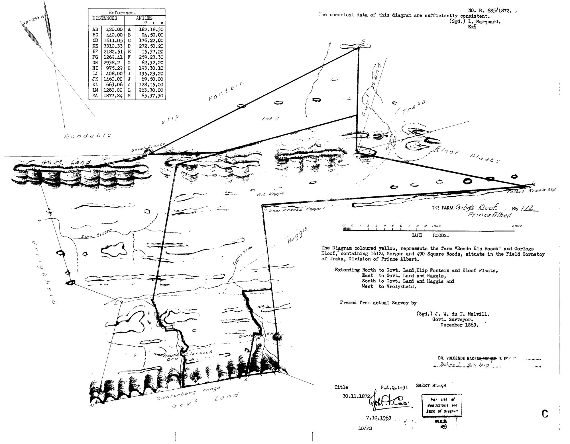
SCAN536.TIF.The record
- Type
- Surveyor-General diagram
- Diagram number
- B.685/1872
- Surveyed
- December 1863
- Titled
- 30 November 1872
- Deed
- P.A.Q.1-31
- Surveyor
- J.W. du T. Melvill
- Examiner
- L. Marquard (Exr)
- Archive filename
- SCAN536.TIF
Citation
- Title
- Roode Els Bosch and Oorlogs Kloof No.172 diagram, 1863/1872
- Repository
- Surveyor-General
- Reference
- SG Dgm B.685/1872
- Type
- SG diagram
The ground it is about
Oorlogs Kloof No. 172 (Roode Els Bosch and Oorlogs Kloof) 172
Research notes
"The Diagram coloured yellow, represents the farm 'Roode Els Bosch' and Oorlogs Kloof, containing 16124 Morgen and 490 Square Roods, situate in the Field Cornetcy of Traka, Division of Prince Albert." "THE FARM Oorlog's Kloof No 172, Prince Albert." Extending North to Govt. Land, Klip Fontein and Kloof Plaats; East to Govt. Land and Haggis; South to Govt. Land and Haggis; WEST TO VROLYKHEID. Framed from actual survey by J.W. du T. MelvillM, Govt. Surveyor, December 1863; "The numerical data of this diagram are sufficiently consistent, (Sgd.) L. MarquardM, Exr." Title 30.11.1872, P.A.Q.1-31. Internal names on the face: Gevel Krantz, Wit Koppe, Rooi Krantz Koppe, Sand River, Charls Kraal, Roode Els Bosch, Oorlogs Kloof, Calbas Kraals Kop; neighbours drawn: Rondable [Rondabel], Klip Fontein, Lot C, Traka, Kloof Plaats, Haggis, Vrolykheid, Zwarteberg range, Govt Land. 1963 SG office copy (7.10.1963), sheet BL-4B. This is the parent record of the whole Roode Els Bosch-Oorlogs Kloof complex; the 1833 loan-farm survey is DOC-0073.
The research behind this page, kept separate from it: dated working notes, open questions, and what is not yet settled.