Part of Vrolikheid
Marinco (Vrolikheid No. 177 Ptn 3)
· on record 1934–1968 · show on the map
The farm's own history, the grant, the original survey, sits on that page.
- Farm number
- No. 177
- Portion
- 3
- District
- Prince Albert
- Extent, as the diagram states it
- 1914.7100 morgen
- Modern surveyed area
- 1622.4 ha
The historic extent and the modern surveyed area are two separate measurements and are not presented here as confirming each other. The first is what a surveyor wrote on a diagram, usually in morgen. The second is what the modern cadastre draws.
Why this farm is here
Vincent Charles Marincowitz held it. 10 km from Klaarstroom.
Vincent Charles Marincowitz is on record on this ground directly. No trace needed.
- story A written history is set on this ground Vrolykheid's story
- parcel Cut out of Vrolikheid
- parcel Related to Wit Plaats (Vrolikheid No. 177 Ptn 1)
- parcel Related to Uitkyk Nek (Vrolikheid No. 177 Ptn 2)
- …and 2 more, listed in full further down this page.
Stories
- about this farm
Vrolykheid's story
The farm where the paper and the people disagree: Stretch's 1833 survey already carrying the names of portions not cut for another century, two titles granted on one day in 1841 - one to an Oosthuisen and one to an 'N. Hitge' whose deed four later portions cite instead - a Trieste immigrant who married a Hitge in 1844 and died holding the farm in 1890, and the death notice that finally put the Hitges on the ground.
Held with the neighbouring portions
One holder had this ground and the pieces below at the same time, so on the ground they were very likely worked as one farm even though the cadastre keeps them apart. Each keeps its own history here; this only records that they were in the same hands.
- from 1935 Wit Plaats (Vrolikheid No. 177 Ptn 1)
- from 1935 Uitkyk Nek (Vrolikheid No. 177 Ptn 2)
- from 1936 Faans Kraal (Vrolikheid No. 177 Ptn 4)
Before this ground was cut out
This is the history of Vrolikheid, the farm this ground was part of until 1934. It is shown here because this ground was that farm, and separately from what follows because before the cut the record says the farm's name and not which part of it. Not everything below necessarily happened on this piece.
- 1822 ownership Jacobus Johannes Oosthuizen (b.1784) (1784-11-19–1867-10-29) loan farm · occupation · confidence high
- 1822 residence Jacobus Johannes Oosthuizen (b.1784) (1784-11-19–1867-10-29) farming
- 1822 residence Anna Magdalena Strijdom (1790-01-12–1846-07-30) farming
- 1833-08 document SG diagram B355/1833 Bf.W.Q.5-1B
- 1833-08 document SG diagram verso B355/1833 (verso)
- 1841-04-15 ownership Jacobus Johannes Oosthuizen (b.1784) (1784-11-19–1867-10-29) Perpetual Quitrent · grant · confidence high
- 1843 residence Charles Frederick Hitge (1818-07~–1846-07-29) stated in a marriage register
- 1846-09-03 document death notice no. 8586
- ../1846-07-29 residence Charles Frederick Hitge (1818-07~–1846-07-29) farming
- 1921 boundary subdivision: becomes Wit Plaats (Vrolikheid No. 177 Ptn 1)
- 1934 boundary subdivision: becomes Uitkyk Nek (Vrolikheid No. 177 Ptn 2)
- 1934 boundary subdivision: becomes Lot B (Vrolikheid No. 177 Ptn 5)
- 1934 boundary subdivision: becomes Faans Kraal (Vrolikheid No. 177 Ptn 4)
- 1934 boundary subdivision: becomes Marinco (Vrolikheid No. 177 Ptn 3)
- 1934 boundary subdivision: becomes Lot A (Vrolikheid No. 177 Ptn 6)
- to 1890-05-13 ownership Ger(H)olm Marincowitz (1805-02-11–1890-05-13) owner · confidence medium
What the record holds, in order
- 1934 boundary change subdivision: from Vrolikheid
-
July 1934
document
SG diagram 4935/1934
11074
- 18 December 1935 boundary change held_together: from Wit Plaats (Vrolikheid No. 177 Ptn 1)
- 18 December 1935 boundary change held_together: from Uitkyk Nek (Vrolikheid No. 177 Ptn 2)
-
18 December 1935
ownership
Vincent Charles Marincowitz (23 April 1877–6 February 1950)
transfer · confidence high
- 24 August 1936 boundary change held_together: becomes Faans Kraal (Vrolikheid No. 177 Ptn 4)
-
the 1960s
burial
Samuel Klaassen
Vrolykheid farm cemetery, Not seen by this project. eGGSA caption: 'KLAASSEN Samuel 1885-196?' - the photographer read the birth year and could not read the last digit of the death year.
-
1968
burial
Elizabeth Caroline "Lizzie" Rill (23 June 1887–13 November 1968)
Vrolykheid farm cemetery
Buried on this ground
- Vrolykheid farm cemetery 2 graves recorded, 1 identified in this project
The burials also appear on this farm's timeline above, each at its own date.
Also bordered by, as the modern cadastre draws it
Ground that touches this farm on the Surveyor-General's current polygons and that none of the diagrams held here names. Derived from the geometry, not read off a document.
- E Oorlogs Kloof No. 172 (Roode Els Bosch and Oorlogs Kloof)
- SW Lot B (Vrolikheid No. 177 Ptn 5)
- SW Witberg No. 180
- W Faans Kraal (Vrolikheid No. 177 Ptn 4)
- NW Vrolikheid
- NW Wit Plaats (Vrolikheid No. 177 Ptn 1)
- NW Lot A (Vrolikheid No. 177 Ptn 6)
Documents
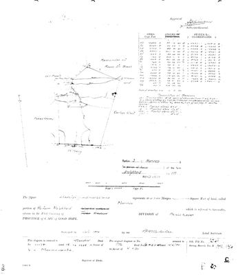 Surveyor-General diagram, 4935/1934, July 1934
101BEF01.TIF
Cadastre
Surveyor-General diagram index for this parcel
Surveyor-General diagram index for the whole farm, where the original survey of this ground sits.
Research notes
SG Dgm 4935/1934; deed 18.12.1935-11074 to V.C. Marincowitz. Named for the Marincowitz family. [CORRECTED 29 Jul 2026, verification pass] Marinco is portion 3, not 5, extent 1914.7100 morgen, not 1934.72: both read off DOC-0068's own face (portion numeral matches the surveyor's 3s in "1934"/"1935"; the disputed extent digit is a plain stroke identical to the 1s in "7100") AND off DOC-0028's verso re-read ("Marinco 177/3, 1914.7100, 18.12.1935-11074"). The earlier "deed conflict" between DOC-0068 and DOC-0028 was an artefact of the mis-transcribed verso - no conflict exists; see OWN-000054. Geometry moved accordingly: SG Ptn 3 (1622.8 ha) fits 1914.71mg = 1639.9 ha within 1.1%. Cites the 1841 N. HitgeM antecedent title (B.W.Q.5.18) - see LEAD-0009. "Marinco" is probably a shortening of MARINCOWITZ - the portion name records the family that took it (transferred to V.C. Marincowitz 1935).
[1 Aug 2026, re-read of DOC-0068 and DOC-0072] FIELD CORNETCY = KREDOUW. On BOTH 1934 Melville diagrams the printed line reads 'situate in the Field Cornetcy of' with TRAKA STRUCK OUT AND KREDOUW WRITTEN IN, in the surveyor's hand. Two independent sheets, the same deliberate correction. So this ground sat in the KREDOUW ward of the Prince Albert division, not the Traka ward - and that is the answer to where 'aan Kriedouw' in the 1821 Beaufort West baptisms points. See LEAD-0052.
[SRC-310, 7 Aug 2026] THE VROLYKHEID FARM CEMETERY IS ON THIS PORTION, at -33.350667, 22.634850, photographed by eGGSA on 14 February 2026 - Cemetery ID 8153. Five stones: SAMUEL KLAASSEN 1885-196? and two captioned UNKNOWN, with two overviews. This project's GRV-0023, Elizabeth Caroline 'Lizzie' Marincowitz nee Rill, buried at Vrolikheid in November 1968, is moved onto this portion on that coordinate. The cemetery sitting on the portion named MARINCO is the first physical support for a burial this project had only from a death notice.
[13 Aug 2026] Renamed to the one form this model uses for every portion - the portion's own name, then the parent farm, its number and the portion in brackets - so that a name is legible in a list, a search result and a map popup without the reader having to know which farm number is which. It read "Marinco (Vrolykheid Ptn 3)" before. Nothing about the ground changed.
*** [23 Aug 2026] CUT ON PAPER, NEVER SPLIT ON THE GROUND. Frans, when the held-together flag surfaced this group: 'vrolikhyd might have been cut, but never split.' The documents say he is right. ***
VINCENT CHARLES MARINCOWITZ (PER-000045, 1877-1950) HELD ALL FOUR PORTIONS: Wit Plaats Ptn 1 from 30 Sept 1922 (deed 8479, diagram 4275/1921); Uitkyk Nek Ptn 2 AND Marinco Ptn 3 on the SAME DAY, 18 December 1935, ON THE SAME DEED 11074; and Faans Kraal Ptn 4 on 24 August 1936 (deed 8110).
THE SURVEYS GIVE IT AWAY. Portions 2, 3 and 4 were all framed in JULY 1934 and carry consecutive diagram numbers - 4932/1934, 4933/1934 and 4935/1934. One survey campaign, one farm, one man. The subdivision was a cadastral act and not a division of occupation.
AND HE DIED ON IT: 6 February 1950, on Vrolikheid (SRC-008).
TWO PORTIONS ON ONE DEED IS THE CLINCHER, because the cadastre itself treated 2 and 3 as a single transaction. The subdivision rule still gives each portion its own page and its own history, which is right - what this note records is that on the ground they were one farm.
The research behind this page, kept separate from it: dated working notes, open questions, and what is not yet settled.
Open questions
-
Our portion numbers do not match the SG on Vrolykheid and Spreeufontein
priority 2 · LEAD-0008
Do our portion numbers for Vrolykheid and Spreeufontein correspond to the Surveyor-General portion numbers, or are they our own sequence?
What would settle it The portion number printed on each diagram, against the SG portion number in the cadastre.
-
N. Hitge's true footprint on Vrolykheid - and his relationship to Frans's own Hitge ancestors
priority 2 · LEAD-0009
Did N. HitgeM's 1841 title (B.W.Q.5.18) actually cover more of Vrolykheid than the ~2,177-morgen Wit Plaats portion recorded for him - and how is N. HitgeM (PER-000044) related to Aletta Catharina Maria Helena HitgeM (PER-000139, Frans's own direct 2x-great-grandmother) and to Hester Carolina Adriana HitgeM (PER-000178, who married into the Marincowitz line)?
What would settle it A record giving N. HitgeM's full given name and naming his children, matched against Aletta Catharina Maria Helena HitgeM (b.1846) and Hester Carolina Adriana HitgeM (b.1826) - if both are his daughters, or one his daughter and the other a niece or cousin, that settles the family relationship and gives a documented reason one 1841 title could legitimately be cited across multiple later Vrolykheid portions, subdivided within the Hitge family before ever reaching Marincowitz hands
What the record is missing
-
The record stops in 1935 and never resumes
third order · B2 trail-ends
Marinco (Vrolikheid No. 177 Ptn 3) was worked as far as 1935-12-18, with Vincent Charles MarincowitzL the last owner on record. 91 years follow with nothing. Who held it after that, and is it still one farm?
What would settle it The current title deed traced backwards, each transfer names the one before it, or the Surveyor-General's subdivision diagrams, which are what usually explain a farm going quiet.
Found by breaks.py reading the model against itself, not written by hand,
each one is a shape of missing record, not a fault in the data.
The whole set is on the
questions page.