Uitkyk No. 12 (Oudtshoorn)
12 on the cadastre · on record 1911 · show on the map
- Farm number
- No. 12
- On the cadastre
- 12, whole farmregistered as UITKYK
- Extent, as the diagram states it
- 2495 morgen 255 square roods
- Modern surveyed area
- 2128.5 ha
The historic extent and the modern surveyed area are two separate measurements and are not presented here as confirming each other. The first is what a surveyor wrote on a diagram, usually in morgen. The second is what the modern cadastre draws.
Why this farm is here
Described by a document in this collection. 12 km from Klaarstroom.
- document A document in the collection describes this ground DOC-0316
What the record holds, in order
- January 1911 document SG diagram 2920
Also bordered by, as the modern cadastre draws it
Ground that touches this farm on the Surveyor-General's current polygons and that none of the diagrams held here names. Derived from the geometry, not read off a document.
- N Klein Valie No. 182
- N Drie Punt No. 181
- E Witberg No. 180
- E Blaauwpunt No. 13 (Oudtshoorn)
- SW Voorzorg No. 24 (Oudtshoorn)
- NW Oude Kraal (Klein Valie No. 182 Ptn 1)
- NW Spitzkop No. 10 (Oudtshoorn)
Documents
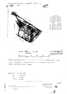 Surveyor-General diagram, 2920, January 1911
10068042.jpg
Cadastre
Surveyor-General diagram index for this parcel
Research notes
SG diagram of January 1911 (DOC-0316), diagram no. 2920: 2495 morgen 255 square roods, with a later metric stamp of 2137,4113 HECTARES. The two agree - 2495 morgen is 2137 ha - and the cadastre polygon draws 2129.4 ha, so the identification is confirmed on the extent before anything rests on it.
*** THE FIELD CORNETCY IS CANGO EAST. *** That is the Cango valley above Oudtshoorn, the country SG 2440 OB of 1877-79 covers (SRC-493), and it is the ground this project has been working towards on the southern Olifants.
Bounded, in the diagram's own words: N.E. by ANNEX UITKYK, S.E. by BLAAUWPUNT, S.W. by VOORZORG, W and S.W. by SPITZKOP. None of the four is in this model yet. Note that the Spitskop this project holds is a portion of Karee Rivier No. 143 in WILLOWMORE and is a different place - 5.
AND NOTE WHAT THIS FARM IS NOT: this project's farm 12 is RIETFONTEIN No. 12 in PRINCE ALBERT (PAR-000156). Farm numbers are per-division and these are unrelated farms.
No owner is named on the sheet; the transfer certificate at the foot is blank.
The research behind this page, kept separate from it: dated working notes, open questions, and what is not yet settled.
Open questions
-
Which cadastral polygons are Annex Uitkyk, Blaauwpunt, Voorzorg and Spitzkop?
priority 2 · LEAD-0241
SG diagram 2920 of 1911 names four farms bounding Uitkyk No. 12 in the Field Cornetcy of Cango East. All four are in the model as NO-POLYGON. Which modern farms are they?
What would settle it Any one of the four neighbours' own diagrams, or the 1879 regional sheet read at the Cango East.
What the record is missing
-
Nobody is on record as ever having held this
third order · B8 never-held
Uitkyk No. 12 (Oudtshoorn) is in the model and drawn on the map, and carries no ownership record of any kind, not a grant, not a transfer, not an occupation.
What would settle it The Surveyor-General's diagram for the farm number names the grantee and the date; the deed reference on it opens the transfer chain.
Found by breaks.py reading the model against itself, not written by hand,
each one is a shape of missing record, not a fault in the data.
The whole set is on the
questions page.