Klein Valie No. 182
182 on the cadastre · on record 1833–2017 · show on the map
- Farm number
- No. 182
- On the cadastre
- 182, whole farmregistered as KLEIN VALIE
- District
- Prince Albert
- Extent, as the diagram states it
- 7215 morgen
- Modern surveyed area
- 6294.4 ha
The historic extent and the modern surveyed area are two separate measurements and are not presented here as confirming each other. The first is what a surveyor wrote on a diagram, usually in morgen. The second is what the modern cadastre draws.
Why this farm is here
Ockert Almero Oosthuizen held it. 12 km from Klaarstroom.
Ockert Almero Oosthuizen is on record on this ground directly. No trace needed.
- story A written history names this ground On 15 April 1841 loan ground becomes property
- story A written history names this ground The men who drew the boundary lines
- story A written history is set on this ground Brokkies uit oupa Almero Oosthuizen se dagboek
- parcel Ground cut out of this farm: Windwaai (Klein Valie No. 182 Ptn 9)
- …and 2 more, listed in full further down this page.
Stories
- mentions this farm
On 15 April 1841 loan ground becomes property
One surveyor works the Koup for two seasons. Seven years later, on a single day, the Crown converts the loan farms to perpetual quitrent: twenty-one deeds on twenty parcels, and the map of the district is set for a century.
- mentions this farm
The men who drew the boundary lines
Every farm here passes through two officials: a veldkornet who knew the ground, and a surveyor paid by the sheet. Forty-two surveyor signatures over 172 years, a century of ward officers, and a ward boundary changing by hand on a 1934 diagram. The first surveyor, C. Lennox Stretch, was later dismissed for taking the Xhosa side.
- set here
Brokkies uit oupa Almero Oosthuizen se dagboek
Almero Oosthuizen van Droogekloof, gebore 1878, skryf sy herinneringe neer op sy skoondogter se versoek: die 1885-vloed deur Meiringspoort, sy oupa wat in 1865 die Middelwaterse lemoenboord met vate natgery het, die perdevrekte van 1892, Klaarstroom se Pietersburg-jare, en die droogtes van 1914, 1926 en 1939. Woordeliks gepubliseer.
What this farm became
From 1912 this ground stopped being one farm, and the story continues on the pieces cut from it. Its own record above ends there; what happened afterwards belongs to a portion, not to the whole.
- 1912 Oude Kraal (Klein Valie No. 182 Ptn 1)
- 1912 Koude Veld (Klein Valie No. 182 Ptn 2)
- 1912 Nieuwe Kraal (Klein Valie No. 182 Ptn 3)
- 1912 Gideon's Hoop (Klein Valie No. 182 Ptn 4)
- 1912 Groote Leegte (Klein Valie No. 182 Ptn 5)
- 1932/1933 Windwaai (Klein Valie No. 182 Ptn 9)
Who stood on this ground, and how they were related
Everyone the record places here - by deed, by residence, or by burial - and the kinship between each pair of them. Two numbers are given and they are deliberately kept apart. Steps is how far apart two people are in the family graph, counting a marriage as one step. The common ancestor is the nearest one they share by blood, with the year they were born. A pair four steps apart through a couple born in the 1750s is a relationship; a pair ten steps apart through a progenitor born in the 1630s is background, because almost everybody descends from him. Read both.
- 1833 Christian Hatting Junior (Klein Valie, 1833) held ../1833
- 1878 Ockert Almero Oosthuizen held ../1878
- 1878 Almero Jacobus Hitge Oosthuizen lived on 1878
- 1897 Jan Müller (bought Klein Vallei, 1897) held 1897
| Steps | Between | Nearest common ancestor by blood |
|---|---|---|
| 1 | Ockert Almero Oosthuizen · Almero Jacobus Hitge Oosthuizen | Susanna Catharina Oosthuizen (b.1819) born 1819 (1+2 generations up) |
Drawn from the parentage and marriages this project holds, never from a shared surname. A pair with no common ancestor here may still be related through a link nobody has recorded yet.
What the record holds, in order
-
August 1833
document
SG diagram B348/1833
Bf.W.Q.5-6
-
before 1833
ownership
Christian Hatting Junior (Klein Valie, 1833)
loan farm · survey · confidence high
-
before 1878 to 1897
ownership
Ockert Almero Oosthuizen (27 November 1836–2 January 1922)
owner · confidence medium
-
1878
lived here
Almero Jacobus Hitge Oosthuizen (18 January 1878–29 October 1961)
memoir
-
1892
event
Ockert Almero Oosthuizen (27 November 1836–2 January 1922), Almero Jacobus Hitge Oosthuizen (18 January 1878–29 October 1961)
Horse-sickness swept the district: of 95 horses and mules on Kouwveldt (PAR-000088), 14 were left. 'Na hierdie vrekte het die donkie sy tuiste in ons wereld gekry' - the donkey arrived in the Koup's world because the horses died out of it. The diary ranks it with the fall of the ostrich-feather market.
-
1897
event
Ockert Almero Oosthuizen (27 November 1836–2 January 1922), Almero Jacobus Hitge Oosthuizen (18 January 1878–29 October 1961), Jan Müller (bought Klein Vallei, 1897)
Ockert Almero Oosthuizen sells Kouwveldt - properly Klein Vallei, PAR-000088 - to Jan Muller and moves his household to his other farm, Droogekloof (PAR-000007). The same year the brandsiekwet came from Rhodes; 'die enigste goeie ding wat hy in Suid-Afrika gedoen het', the diary says, with the district protesting.
-
1897
ownership
Jan Müller (bought Klein Vallei, 1897)
purchase · confidence medium
- 1912 boundary change subdivision: becomes Oude Kraal (Klein Valie No. 182 Ptn 1)
- 1912 boundary change subdivision: becomes Koude Veld (Klein Valie No. 182 Ptn 2)
- 1912 boundary change subdivision: becomes Nieuwe Kraal (Klein Valie No. 182 Ptn 3)
- 1912 boundary change subdivision: becomes Gideon's Hoop (Klein Valie No. 182 Ptn 4)
- 1912 boundary change subdivision: becomes Groote Leegte (Klein Valie No. 182 Ptn 5)
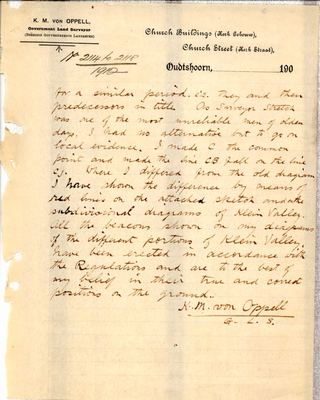
- 30 July 1912 document survey report 2114-2118/1912 (sketch)
- 30 July 1912 document survey report 2114-2118/1912 (report p1)
- 30 July 1912 document survey report 2114-2118/1912 (report p2)
- 1919 document SG diagram verso B348/1833 (verso)
-
1929
burial
Abraham Petrus Muller
Kleinvlei farm cemetery, Klein Valie 182
-
1929
burial
Catherina Elizabeth Botha
Kleinvlei farm cemetery, Klein Valie 182
- 1932–1933 boundary change subdivision: becomes Windwaai (Klein Valie No. 182 Ptn 9)
-
1941
burial
Hester Maria Fouche
Kleinvlei farm cemetery, Klein Valie 182
-
1971
burial
Johannes Christian Ellis
Kleinvlei farm cemetery, Klein Valie 182
-
1972
burial
Johannes J.C Ellis
Kleinvlei farm cemetery, Klein Valie 182
-
2009
burial
Johanna F Koekemoer
Kleinvlei farm cemetery, Klein Valie 182
-
2012
burial
Johannes Christian Ellis
Kleinvlei farm cemetery, Klein Valie 182
-
2014
burial
Adriana Beatrix Lucas
Kleinvlei farm cemetery, Klein Valie 182
-
2017
burial
Bennie Ellis
Kleinvlei farm cemetery, Klein Valie 182
Ground cut out of this farm
- Windwaai (Klein Valie No. 182 Ptn 9) 318.9 ha
- Oude Kraal (Klein Valie No. 182 Ptn 1) 1793.1 ha
- Koude Veld (Klein Valie No. 182 Ptn 2)
- Nieuwe Kraal (Klein Valie No. 182 Ptn 3) 825.8 ha
- Gideon's Hoop (Klein Valie No. 182 Ptn 4) 2019.0 ha
- Groote Leegte (Klein Valie No. 182 Ptn 5) 296.2 ha
- Kouveld (Klein Valie No. 182 Ptn 6) 389.6 ha
- Groenkraal (Klein Valie No. 182 Ptn 7) 319.5 ha
- Grootleegte (Klein Valie No. 182 Ptn 8) 322.5 ha
- Klein Valie No. 182 Ptn 10 (out of Oude Kraal) 9.9 ha
Bordered by, as the diagram names them
- N Middle water and Government ground
- S Zwarte Berg
- E Wilga-mount (Wilgemond)
On the 1915 divisional map
As the Surveyor-General printed this farm in 1915: the registered holder, the date the title was issued and its quitrent reference, copied off the sheet as written. The whole map, farm by farm
| Farm, as printed | Holder | Title | Quitrent | Note |
|---|---|---|---|---|
| DE AAR & KLEINE VALLEI | O. Hattingh D. son | 15 April 1841 | B.W.Q. 5.6 · fol. 953 | Aape River |
Buried on this ground
- Kleinvlei farm cemetery, Klein Valie 182 9 graves recorded
The burials also appear on this farm's timeline above, each at its own date.
Also bordered by, as the modern cadastre draws it
Ground that touches this farm on the Surveyor-General's current polygons and that none of the diagrams held here names. Derived from the geometry, not read off a document.
- NE Avondrust (Middelwater No. 169 Ptn 6)
- NE Middelwater No. 169 Ptn 1
- E De Claar Stroom (Klaarstroom No. 178)
- E Gideon's Hoop (Klein Valie No. 182 Ptn 4)
- E Kouveld (Klein Valie No. 182 Ptn 6)
- E Groenkraal (Klein Valie No. 182 Ptn 7)
- SE Groote Leegte (Klein Valie No. 182 Ptn 5)
- SE Grootleegte (Klein Valie No. 182 Ptn 8)
- S Drie Punt No. 181
- S Uitkyk No. 12 (Oudtshoorn)
- SW Spitzkop No. 10 (Oudtshoorn)
- W Oude Kraal (Klein Valie No. 182 Ptn 1)
- W Nieuwe Kraal (Klein Valie No. 182 Ptn 3)
- NW Klaarstroom No. 184 (Klaarstroom A)
- NW Venters Kloof Annex No. 183
Documents
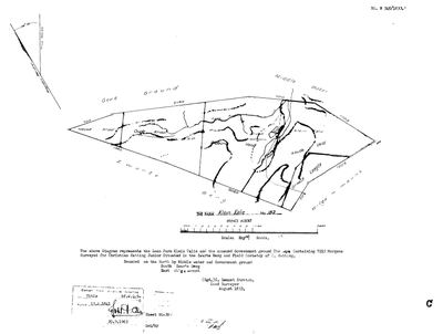 Surveyor-General diagram, B348/1833, August 1833
SCAN498.jpg
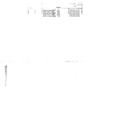 Diagram verso, B348/1833 (verso), 1919
SCAN499.jpg
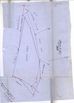 survey_report, 2114-2118/1912 (sketch), 30 July 1912
10696183.pdf
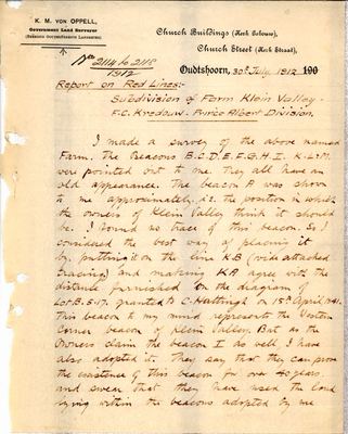 survey_report, 2114-2118/1912 (report p1), 30 July 1912
10696184.pdf
 survey_report, 2114-2118/1912 (report p2), 30 July 1912
10696185.pdf
Cadastre
Surveyor-General diagram index for this parcel
Research notes
[31 Jul 2026 inbox] Two farms west of Vrolikheid, bounded east by Wilgamount. Loan farm surveyed Aug 1833 by Stretch for Christian Hatting JuniorH, with the annexed Government ground 'The Ape'; titled 15 Apr 1841 on Bf.W.Q.5-6 (DOC-0119). Wholly subdivided in 1919 into five named pieces that sum exactly to the 1833 extent - Oude Kraal 182/1 (1737 mrg), Koude Veld 182/2 (2222), Nieuwe Kraal 182/3 (408), Gideons Hoop 182/4 (2335), Groote Leegte 182/5 (513); deeds 11089 and 11090 of 1919 (DOC-0120). Those five are NOT given rows here - they are one hop beyond the land story and the detail is on this row and on SRC-150. AREA CHECK: 7215 morgen converts to 6,180 ha against a modern 6,297.2 - agreement to 1.9%, which is worth recording against LEAD-0007 because Middelwater's portions disagree by 25-29% and Klipfontein's by 20%. The discrepancy is clearly not universal.
[SRC-010, Rose Willis Klaarstroom cameo. TERTIARY, TO VERIFY] LEAD-0026 largely answered: GIDEONSHOOP - the farm of the Langenhoven and Helena de Vries story, north of the Swartberg - 'today is the DE AAP GUEST FARM'. 'De Aap' is 'The Ape', the annexed Government ground on this farm's own 1833 diagram and on Wilgemond's; and Gideons Hoop is this farm's portion 182/4 on the 1919 verso (SRC-150). So The Ape was not a separate holding that vanished - the name survives on the ground to this day.
[SRC-317, 7 Aug 2026] A FARM CEMETERY IS RECORDED ON THIS GROUND BY eGGSA: 'Klein Valie 182, Kleinvlei', Cemetery ID 7650, at -33.351667, 22.449950. Photographs and captions at https://graveswcape.eggsa.org/PRINCE-ALBERT-Rural/Klaarstroom-Kleinvlei/ - linked, not copied.
The research behind this page, kept separate from it: dated working notes, open questions, and what is not yet settled.
Open questions
-
Wilgemond's diagram number: 150/1833, or 350 mis-transcribed in 1952?
priority 2 · LEAD-0025
Every other farm in Stretch's August 1833 run carries a diagram number between 348 and 369, and their quitrent folios rise with them. Wilgemond is numbered 150/1833 yet holds folio 5-9, which falls exactly inside that run. Is the number wrong?
What would settle it The original diagram, or the SG's index of 1833 Prince Albert diagrams.
-
Who were the 'others' in the 1940 Klein Valie water transfer?
priority 2 · LEAD-0106
A 12-morgen river parcel on Klein Valie carrying a weir, surveyed 1938, was transferred in 1940 to 'Lategan AND OTHERS', with conduit servitudes running across the neighbouring portion. Who were the others, and was this an irrigation syndicate?
What would settle it The deed's list of names.
-
Who was 'The Ape', and who ended up with it?
priority 3 · LEAD-0026
Both the Wilgemond and Klein Valie surveys of 1833 annex a piece of Government ground called THE APE, and Wilgemond is bounded on the north by it. What is it, where is it, and is the name Die Aap?
What would settle it Any map or deed naming it.
-
Two parcel_links rows share the id PLK-000019
priority P2 · LEAD-0312
Two different subdivisions carry one link id. Which row keeps PLK-000019, and which is renumbered?
What would settle it Frans's call on which keeps the id. NOT fixed silently: 3 says ids are permanent, so renumbering somebody else's row is a decision, not a tidy-up.
What the record is missing
-
45 years, and the ground changes hands to nobody we can follow
first order · B1 succession
On Klein Valie No. 182, Christian Hatting JuniorH (Klein Valie, 1833) is the last owner recorded from ../1833, and the next entry is Ockert Almero OosthuizenL from ../1878, 45 years later, with no person in common. No document records the handover at all.
What would settle it The Deeds Office transfer register for this farm between 1833 and 1878. A transfer names its predecessor in title, so one deed closes the whole gap.
-
19 years, and the ground changes hands to nobody we can follow
first order · B1 succession
On Klein Valie No. 182, Ockert Almero OosthuizenL is the last owner recorded from ../1878, and the next entry is Jan MüllerH (bought Klein Vallei, 1897) from 1897, 19 years later, with no person in common. No document records the handover at all.
What would settle it The Deeds Office transfer register for this farm between 1878 and 1897. A transfer names its predecessor in title, so one deed closes the whole gap.
-
The record stops in 1897 and never resumes
second order · B2 trail-ends
Klein Valie No. 182 was worked as far as 1897, with Ockert Almero OosthuizenL the last owner on record. 129 years follow with nothing. Who held it after that, and is it still one farm?
What would settle it The current title deed traced backwards, each transfer names the one before it, or the Surveyor-General's subdivision diagrams, which are what usually explain a farm going quiet.
Found by breaks.py reading the model against itself, not written by hand,
each one is a shape of missing record, not a fault in the data.
The whole set is on the
questions page.