Klaarstroom No. 184 (Klaarstroom A)
184 on the cadastre · on record 1833–1841 · show on the map
- Farm number
- No. 184
- On the cadastre
- 184, whole farmregistered as KLAARSTROOM
- District
- Prince Albert
- Extent, as the diagram states it
- 2773 morgen 100 roods
- Modern surveyed area
- 2227.0 ha
The historic extent and the modern surveyed area are two separate measurements and are not presented here as confirming each other. The first is what a surveyor wrote on a diagram, usually in morgen. The second is what the modern cadastre draws.
Why this farm is here
Christian Hatting Senior held it. Connected to the Oosthuizen, Marincowitz or Van der Merwe lines BY MARRIAGE, not by blood, 5 steps on the shortest path. 19 km from Klaarstroom.
- Christian Hatting Senior
- married to Maria Christina Venter (1786-1875)
- child of Willem Venter (b.1761)
- parent of Jan Adriaan Venter
- parent of Willem Venter
- married to Anna Christina Oosthuizen
Each step is a recorded parentage or marriage in this model, and the shortest one the record supports, follow the names to check it.
- story A written history is set on this ground On 15 April 1841 loan ground becomes property
- story A written history names this ground Vrolykheid's story
- story A written history names this ground Middelwater's story since 1777
- story A written history names this ground From Petersburg to Klaarstroom, a history since 1777
- …and 2 more, listed in full further down this page.
Stories
- about this farm
On 15 April 1841 loan ground becomes property
One surveyor works the Koup for two seasons. Seven years later, on a single day, the Crown converts the loan farms to perpetual quitrent: twenty-one deeds on twenty parcels, and the map of the district is set for a century.
- mentions this farm
Vrolykheid's story
The farm where the paper and the people disagree: Stretch's 1833 survey already carrying the names of portions not cut for another century, two titles granted on one day in 1841 - one to an Oosthuisen and one to an 'N. Hitge' whose deed four later portions cite instead - a Trieste immigrant who married a Hitge in 1844 and died holding the farm in 1890, and the death notice that finally put the Hitges on the ground.
- mentions this farm
Middelwater's story since 1777
From a loan farm on the Zwartberg to eight cadastral parcels: the full documented history of Middelwater No. 169 - Stretch's 1833 survey for Okert Oosthuizen, the twelve-farm grant day of 1841, the 1883 resurvey and the 1884 quitrent to J.D.J. Oosthuysen 'and another', the portions cut off for a spring called Vaste Water and a place called Avondrust, and the 1990 power-line survey whose coordinates finally put the farm on a map.
- mentions this farm
From Petersburg to Klaarstroom, a history since 1777
The loan farm De Claar Stroom (Klaarstroom No. 178), granted 1777, is the ground Klaarstroom village stands on, not to be confused with Klaarstroom No. 184, which is Christian Hatting's grant 19 km west. Meiringspoort opened in 1858; twenty-seven erven were laid out on Petrus Oosthuizen's land and the village was called Petersburg for him. The erven were sold WITHOUT water rights. Who Petrus was is still unknown, and the one testable fact about him is a brother named Ockert.
- mentions this farm
The men who drew the boundary lines
Every farm here passes through two officials: a veldkornet who knew the ground, and a surveyor paid by the sheet. Forty-two surveyor signatures over 172 years, a century of ward officers, and a ward boundary changing by hand on a 1934 diagram. The first surveyor, C. Lennox Stretch, was later dismissed for taking the Xhosa side.
What the record holds, in order
-
August 1833
document
SG diagram 354/1833
Bf.W.Q.5-17
-
15 April 1841
ownership
Christian Hatting Senior (1772–1848)
Perpetual Quitrent · grant · confidence high
Bordered by, as the diagram names them
- N Versch Gewagt (loan farm)
- S The Ape
- E Bloemendal
- W Government Ground
Also bordered by, as the modern cadastre draws it
Ground that touches this farm on the Surveyor-General's current polygons and that none of the diagrams held here names. Derived from the geometry, not read off a document.
- N Vrisch Gewagt No. 163
- NE Bloemendaal No. 165
- E Venters Kloof Annex No. 183
- SE Oude Kraal (Klein Valie No. 182 Ptn 1)
- S Nieuwe Kraal (Klein Valie No. 182 Ptn 3)
- W State Land Farm No. 185
Documents
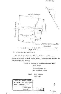 Surveyor-General diagram, 354/1833, August 1833
10TVW601 (1).TIF
Cadastre
Surveyor-General diagram index for this parcel
Research notes
Government ground surveyed for Christian Hatting SeniorH, Aug 1833; titled 15 Apr 1841. Bounded N by the loan farm Versch Gewagt, S The Ape, E Bloemendale, W Government Ground.
The research behind this page, kept separate from it: dated working notes, open questions, and what is not yet settled.
What the record is missing
-
The record stops in 1841 and never resumes
second order · B2 trail-ends
Klaarstroom No. 184 (Klaarstroom A) was worked as far as 1841-04-15, with Christian Hatting SeniorH the last owner on record. 185 years follow with nothing. Who held it after that, and is it still one farm?
What would settle it The current title deed traced backwards, each transfer names the one before it, or the Surveyor-General's subdivision diagrams, which are what usually explain a farm going quiet.
Found by breaks.py reading the model against itself, not written by hand,
each one is a shape of missing record, not a fault in the data.
The whole set is on the
questions page.