Vrisch Gewagt No. 163
163 on the cadastre · on record 1833–1925 · show on the map
- Farm number
- No. 163
- On the cadastre
- 163, whole farmregistered as VRISCH GEWAGT
- District
- Prince Albert
- Extent, as the diagram states it
- 1712 morgen
- Modern surveyed area
- 1177.9 ha
The historic extent and the modern surveyed area are two separate measurements and are not presented here as confirming each other. The first is what a surveyor wrote on a diagram, usually in morgen. The second is what the modern cadastre draws.
Why this farm is here
Pieter Marthinus Oosthuizen is buried here. 19 km from Klaarstroom.
Pieter Marthinus Oosthuizen is on record on this ground directly. No trace needed.
- parcel Ground cut out of this farm: Lot A (Vrisch Gewagt No. 163 Ptn 1)
- parcel Ground cut out of this farm: Vris-Gewaagd B (Vrisch Gewagt No. 163 Ptn 2)
- document A document in the collection describes this ground DOC-0164
- document A document in the collection describes this ground DOC-0165
- …and 2 more, listed in full further down this page.
Who stood on this ground, and how they were related
Everyone the record places here - by deed, by residence, or by burial - and the kinship between each pair of them. Two numbers are given and they are deliberately kept apart. Steps is how far apart two people are in the family graph, counting a marriage as one step. The common ancestor is the nearest one they share by blood, with the year they were born. A pair four steps apart through a couple born in the 1750s is a relationship; a pair ten steps apart through a progenitor born in the 1630s is background, because almost everybody descends from him. Read both.
- 1841 Isaak van der Westhuizen held 1841-04-15
- 1911 Aletta Elizabeth le Grange buried on · buried on 1911 · buried on 1911-03-10
- 1925 Pieter Marthinus Oosthuizen buried on 1925 · buried on 1925-08-31
| Steps | Between | Nearest common ancestor by blood |
|---|---|---|
| 1 | Aletta Elizabeth le Grange · Pieter Marthinus Oosthuizen | none within twelve generations |
Drawn from the parentage and marriages this project holds, never from a shared surname. A pair with no common ancestor here may still be related through a link nobody has recorded yet.
What the record holds, in order
-
August 1833
document
SG diagram B.352/1833
Bf.W.Q.5-11
- 1833 document SG diagram verso B.352/1833 (verso)
-
August 1833
document
SG diagram B352/1833
Bf.W.Q.5-11
-
15 April 1841
ownership
Isaak van der Westhuizen
quitrent · grant · confidence high
- 1904 boundary change subdivided_into: becomes Lot A (Vrisch Gewagt No. 163 Ptn 1)
-
10 March 1911
burial
Aletta Elizabeth le Grange (25 April 1859–10 March 1911)
Vrisch Gewacht 163 farm cemetery, Not read by this project; recorded from the eGGSA caption, which is a transcription made by somebody else.
-
1911
burial
Aletta Elizabeth le Grange (25 April 1859–10 March 1911)
Vrisch Gewacht 163 farm cemetery
- 1922 boundary change subdivided_into: becomes Vris-Gewaagd B (Vrisch Gewagt No. 163 Ptn 2)
- 1922 document SG diagram verso B352/1833 (verso)
-
31 August 1925
burial
Pieter Marthinus Oosthuizen (about 1850–31 August 1925)
Vrisch Gewacht 163 farm cemetery, Not read by this project; recorded from the eGGSA caption, which is a transcription made by somebody else.
-
undated
burial
Pieter Marthinus Oosthuizen (about 1850–31 August 1925)
Vrisch Gewacht 163 farm cemetery
-
undated
burial
Aletta Elizabeth le Grange (25 April 1859–10 March 1911)
Vrisch Gewacht 163 farm cemetery
Ground cut out of this farm
On the 1915 divisional map
As the Surveyor-General printed this farm in 1915: the registered holder, the date the title was issued and its quitrent reference, copied off the sheet as written. The whole map, farm by farm
| Farm, as printed | Holder | Title | Quitrent | Note |
|---|---|---|---|---|
| VRISCH GEWAAGD | I. v. d. Westhuizen | 15 April 1841 | B.W.Q. 5.11 · fol. 958 |
Buried on this ground
- Vrisch Gewacht 163 farm cemetery 5 graves recorded, 5 identified in this project
The burials also appear on this farm's timeline above, each at its own date.
Also bordered by, as the modern cadastre draws it
Ground that touches this farm on the Surveyor-General's current polygons and that none of the diagrams held here names. Derived from the geometry, not read off a document.
- E Bloemendaal No. 165
- E Bloemendal A No. 166
- SE Venters Kloof Annex No. 183
- S Klaarstroom No. 184 (Klaarstroom A)
- W State Land Farm No. 185
- NW Kraai Fontein No. 221
Documents
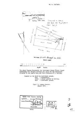 Surveyor-General diagram, B.352/1833, August 1833
10OUR301 vrisch 1.jpg
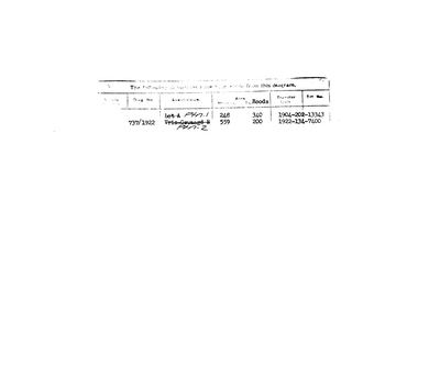 Diagram verso, B.352/1833 (verso), 1833
10OUR501 vrisch 2.jpg
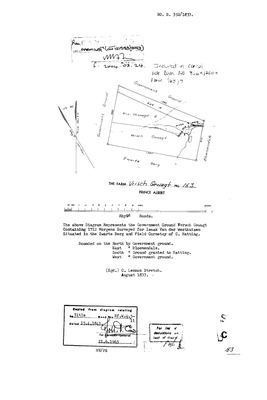 Surveyor-General diagram, B352/1833, August 1833
10OUR301
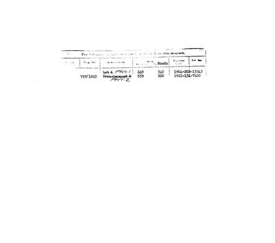 Diagram verso, B352/1833 (verso), 1922
10OUR501
Cadastre
Surveyor-General diagram index for this parcel
Research notes
[2 Aug 2026 inbox] "The above Diagram Represents the Government Ground Versch Gewagt Containing 1712 Morgens Surveyed for ISAAK VAN DER WESTHUIZEN, Situated in the Zwarte Berg and Field Cornetcy of C. HattingM." C. LENNOX STRETCH, AUGUST 1833 (DOC-0164). Bounded N and W by Government ground, E by Bloemendale, S by GROUND GRANTED TO HATTING - which is Klaarstroom No. 184, whose own 1833 diagram returns the compliment by naming 'the Loan Farm Versch Gewagt' as its northern boundary. The two sheets corroborate each other exactly. Titled Bf.W.Q.5-11 on 15 APRIL 1841, so it joins the twelve-farm grant day (STO-0007). Verso (DOC-0165): Ptn 1, ex 'Lot A', 248 mg 340 rds, transferred 1904; Ptn 2, ex 'Vris Gewaagd B', 559 mg 200 rds, dgm 737/1922, transferred 1922. CANCELLED 2004-03-24 vide Farm 163/7 (CCT 121583/2003), consolidated per Dgm 3663/2003.
[SRC-326, 7 Aug 2026] A FARM CEMETERY IS RECORDED ON THIS GROUND BY eGGSA: 'Vrisch Gewacht 163, Vrischgewaagd', Cemetery ID 1092, at -33.276250, 22.357317. Photographs and captions at https://graveswcape.eggsa.org/PRINCE-ALBERT-Rural/1023020%20Vrischgewaagd%20Prince%20Albert%20_Pieter%20Olckers/ - linked, not copied. || [15 Aug 2026 inbox, SRC-440/DOC-0299 + SRC-441/DOC-0300] ITS DIAGRAM, ITS GRANT AND ITS PORTIONS. S.G. dgm B352/1833: 1712 morgen of Government Ground, surveyed by C. Lennox Stretch in August 1833 for ISAAK VAN DER WESTHUIZEN, in the Zwarte Berg and the field cornetcy of C. HattingM. Titled Bf.W.Q.5-11 on 15 APRIL 1841 - grant day. Bounded N and W by Government ground, E by Bloemendale, S by ground granted to Hatting.
TWO PORTIONS CAME OFF IT and are now rows here: PAR-000275 Lot A (Ptn 1, 248 mg 340 sr, 1904) and PAR-000276 Vris-Gewaagd B (Ptn 2, 559 mg 200 sr, 1922).
CANCELLED in 2003, included in a consolidation vide dgm 3663/2003 as farm 163/7.
The research behind this page, kept separate from it: dated working notes, open questions, and what is not yet settled.
Open questions
-
Which Vrischgewaagd did Pieter Marthinus Oosthuizen die on, and how does his household reach this record?
priority 1 · LEAD-0188
[FAMILY] Interesting, i did not know this farm was in family! vrischgewag. PER-000846, Pieter Marthinus OosthuizenH (FS GMGP-4RD, 1850-1925), is already in this model as a thin row. His 1925 death notice gives his usual residence AND his intended burial place as VRISCHGEWAAGD, district Prince Albert. This project draws two farms of that name - Vrisch Gewagt No. 163 (PAR-000130) and Vrisgewaagd No. 152 (PAR-000267) - and the 2023 valuation roll names a third piece, farm 163 portion 7, and a fourth on farm 221. WHICH ONE, and is he buried there?
What would settle it A grave, a deed, or a coordinate. Any one of the three names the farm; an argument from the name alone will not, as the Bloemendal case showed on 13-14 Aug 2026.
What the record is missing
-
The record stops in 1841 and never resumes
second order · B2 trail-ends
Vrisch Gewagt No. 163 was worked as far as 1841-04-15, with Isaak van der WesthuizenH the last owner on record. 185 years follow with nothing. Who held it after that, and is it still one farm?
What would settle it The current title deed traced backwards, each transfer names the one before it, or the Surveyor-General's subdivision diagrams, which are what usually explain a farm going quiet.
Found by breaks.py reading the model against itself, not written by hand,
each one is a shape of missing record, not a fault in the data.
The whole set is on the
questions page.