Bloemendaal No. 165
165 on the cadastre · on record 1825 · show on the map
- Farm number
- No. 165
- On the cadastre
- 165, whole farmregistered as BLOEMENDAL
- District
- Prince Albert
- Extent, as the diagram states it
- 3000 morgen
- Modern surveyed area
- 1344.6 ha
The historic extent and the modern surveyed area are two separate measurements and are not presented here as confirming each other. The first is what a surveyor wrote on a diagram, usually in morgen. The second is what the modern cadastre draws.
Why this farm is here
Gert Annis Oosthuizen Marincowitz held it. 16 km from Klaarstroom.
Gert Annis Oosthuizen Marincowitz is on record on this ground directly. No trace needed.
- story A written history is set on this ground The war reaches the Koup
- border Shares a boundary with Venters Kloof No. 168 Venters Kloof No. 168
- border Shares a boundary with Reim Hoogte No. 167 Reim Hoogte No. 167
- border Shares a boundary with Venters Kloof Annex No. 183 Venters Kloof Annex No. 183
- …and 2 more, listed in full further down this page.
Stories
- set here
The war reaches the Koup
The Anglo-Boer War came to these farms twice: up the road from Klaarstroom on 2 February 1901, when a running fight through Die Gang left three men dead, a Boer of Scheepers's commando and two British soldiers, and a farmer buried all three; and quietly in 1903, when a woman from Tulbagh married into a Prince Albert family having lost two brothers in Natal thirty-four days apart.
What the record holds, in order
-
7 May 1825
document
SG diagram B493/1845
Bf.W.Q.8-1
- 7 May 1825 document SG diagram verso B493/1845 (verso)
-
undated
ownership
Gert Annis Oosthuizen Marincowitz (17 February 1919–4 July 2003)
freehold · owner · confidence medium
On the 1915 divisional map
As the Surveyor-General printed this farm in 1915: the registered holder, the date the title was issued and its quitrent reference, copied off the sheet as written. The whole map, farm by farm
| Farm, as printed | Holder | Title | Quitrent | Note |
|---|---|---|---|---|
| BLOEMENDAL | Est. late J. J. Graaff J. G. son | 31 January 1845 | B.W.Q. 8.1 · fol. 1262 |
Also bordered by, as the modern cadastre draws it
Ground that touches this farm on the Surveyor-General's current polygons and that none of the diagrams held here names. Derived from the geometry, not read off a document.
- N Tabaklande (Bloemendal Annex No. 164 Ptn 2)
- E Reim Hoogte No. 167
- SE Venters Kloof No. 168
- S Venters Kloof Annex No. 183
- SW Klaarstroom No. 184 (Klaarstroom A)
- W Vrisch Gewagt No. 163
- W Kraai Fontein No. 221
- NW Bloemendal Annex No. 164
- NW Bloemendal A No. 166
Documents
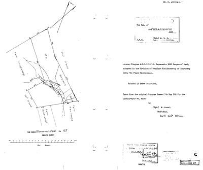 Surveyor-General diagram, B493/1845, 7 May 1825
SCAN561.jpg
 Diagram verso, B493/1845 (verso), 7 May 1825
SCAN562.jpg
Cadastre
Surveyor-General diagram index for this parcel
Research notes
[31 Jul 2026 inbox] North of Venters Kloof and west of Reim Hoogte. Its diagram (DOC-0129) is a redraw of an ORIGINAL FRAMED 7 MAY 1825 by the surveyor Bower - eight years before Stretch's season and the oldest survey in this model. Titled 31 Jan 1845 on Bf.W.Q. 8-1, a different volume and date from the 1841 series. Ten portions came off between 1859 and 1953 (DOC-0130). Modern cadastre 1,345.3 ha against an original 2,569.6 - most of the farm has gone.
[SRC-010, Rose Willis Klaarstroom cameo. TERTIARY, TO VERIFY] 'On the night of 2 February 1901, Scheepers and his men stayed over at the farm BLOEMENDAL west of Klaarstroom. In 1935, the farm owner, PIET OOSTHUIZEN, renamed a portion of the farm as SCHEEPERSRUS.' We hold no owner for this farm at any date, so both the 1935 Oosthuizen ownership and the portion name are new and unverified. Years later, in 1970, rifle parts thrown into the Groot River by the commando washed up at Scheepersrus.
[14 Aug 2026, FAMILY] THE FARM TOKKIE HELD, AND THE FIRST OWNER THIS ROW HAS EVER CARRIED. Frans gave the Bloemendal house as -33.274613 / 22.388809, explicitly correcting a point given the day before; it falls inside this polygon. So Gert Annis "Tokkie" Oosthuizen Marincowitz (PER-000007) held THIS Bloemendal, not Bloemendal A No. 166 where OWN-000105 sat overnight. The werf is PLC-000080. He held Tabaklande as well, which is farm 164 portion 2, so the two holdings are separate farms about 2 km apart. NO DATES - family knowledge gives the fact and not the years.
WORTH TESTING, NOT ASSUMING: the note above records SRC-010, a tertiary Rose Willis cameo, saying the owner of this farm in 1935 was a PIET OOSTHUIZEN who renamed a portion Scheepersrus after Scheepers's commando stayed here on 2 February 1901. Until today this row had no owner at any date and that cameo had nothing to attach to. It now sits beside a family holding, and Tokkie's own surname is Oosthuizen Marincowitz. That is a reason to look, and it is NOT a finding: the cameo is [TO VERIFY], no Piet is identified, and a shared surname in this district is close to no evidence at all.
*** [SRC-010, 3 Sep 2026] THIS IS SCHEEPERSRUS. *** Scheepers's commando spent the night of 2 February 1901 here; a portion was renamed SCHEEPERSRUS in 1935 by the farm owner Piet Oosthuizen, unidentified in this model. British troops' rifles, taken and wrecked after the Die Gang chase, were thrown into the Groot River and rifle parts washed up here in a 1970 flood. Held by this family still: Tokkie [FAMILY]. LEAD-0339.
The research behind this page, kept separate from it: dated working notes, open questions, and what is not yet settled.
Open questions
-
Six parcels whose surveyed extent is far from their polygon with no reason recorded
priority 2 · LEAD-0093
For each, is the extent mistyped, or did ground leave the farm without a note?
What would settle it The deduction table. It lists portion, name, extent, diagram and deed on one line.
-
Which Bloemendal did Tokkie own, and when did he hold it and Tabaklande?
priority 2 · LEAD-0187
[FAMILY] Tokkie also owned Bloemendal and Tabaklande. Tabaklande is unambiguous - farm 164 portion 2, now PAR-000201. BLOEMENDAL IS NOT: this district has three farms of that name and a fourth thing called Bloemendal inside one of them. Bloemendal Annex No. 164 (PAR-000128), Bloemendaal No. 165 (PAR-000093), Bloemendal A No. 166 (PAR-000129), and the 2023 valuation roll also names farm 165 portion 2 'Bloemendal' at 15.4 ha. Which one is it, and what are the dates of both holdings?
What would settle it Frans naming which Bloemendal, or a deeds report showing the transfers in and out.
-
Who was Piet Oosthuizen, who renamed part of Bloemendaal Scheepersrus in 1935?
priority P3 · LEAD-0339
The Klaarstroom cameo names 'the farm owner, Piet Oosthuizen' as the man who in 1935 renamed a portion of Bloemendaal (PAR-000093) Scheepersrus, commemorating Scheepers's overnight stay there in 1901. Bloemendaal is held by Tokkie's family today [FAMILY, no deed]. Is Piet Oosthuizen an ancestor in that line, and under 5b is Piet a noemnaam for Petrus?
What would settle it A deed or valuation roll naming the 1935 owner.