Bloemendal Annex No. 164
164 on the cadastre · on record 1913 · show on the map
- Farm number
- No. 164
- On the cadastre
- 164, whole farmregistered as BLOEMENDAL ANNEX
- District
- Prince Albert
- Extent, as the diagram states it
- 3080 morgen 299 square roods
- Modern surveyed area
- 1137.6 ha
The historic extent and the modern surveyed area are two separate measurements and are not presented here as confirming each other. The first is what a surveyor wrote on a diagram, usually in morgen. The second is what the modern cadastre draws.
Why this farm is here
A piece of a farm already in this model. 19 km from Klaarstroom.
- parcel Ground cut out of this farm: Tabaklande (Bloemendal Annex No. 164 Ptn 2)
- document A document in the collection describes this ground DOC-0160
- document A document in the collection describes this ground DOC-0161
What the record holds, in order
- March 1913 document SG diagram 3198 (1010 struck)
- March 1913 document SG diagram verso 3198 (verso)
Ground cut out of this farm
Also bordered by, as the modern cadastre draws it
Ground that touches this farm on the Surveyor-General's current polygons and that none of the diagrams held here names. Derived from the geometry, not read off a document.
- N Klein Sleutlefontein No. 127
- NE Groot Sluitel Fontein No. 126
- NE Tabaklande (Bloemendal Annex No. 164 Ptn 2)
- E Rhemhoogte No. 125
- E Groot Sleutelfontein (Rhemhoogte No. 125 Ptn 2)
- SE Reim Hoogte No. 167
- SE Bloemendaal No. 165
- W Kraai Fontein No. 221
- W Luiperdkop No. 240
Documents
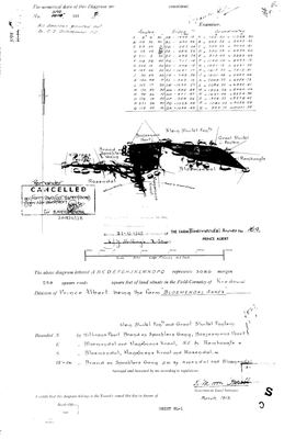 Surveyor-General diagram, 3198 (1010 struck), March 1913
11559001 bloem annex.jpg
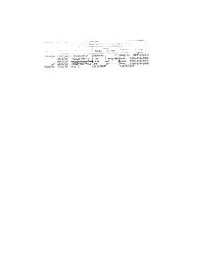 Diagram verso, 3198 (verso), March 1913
11559002 bloem annex 2.jpg
Cadastre
Surveyor-General diagram index for this parcel
Research notes
[2 Aug 2026 inbox] The farm PAR-000007 'Drooge Kloof' was wrongly drawn on. Field-Cornetcy of KREDOUW, Division of Prince Albert; 3,080 morgen 299 sq roods; surveyed and beaconed by K.M. von OppellM, March 1913 (DOC-0160). Bounded N by Witkrans Poort, Brand en Spochlers Gang, Bosjesmans Poort, Klein Sluitel Fontein and Groot Sluitel Fontein; E by Bloemendal and Magemans Kraal, NE by Remhoogte; S by Bloemendal, Magemans Kraal and Rosendal; W-SW by Brand en Spochlers Gang, SW by Rosendal and Bloemendal. So it adjoins Klein Sleutelfontein, Groot Sluitel Fontein and Rhemhoogte, all already in this model, which is why it belongs here. Transfer 21.12.1925. CANCELLED 2018-11-28, vide FARM 240 (CCT 51997/2018), Dgm 2601/2017.
The research behind this page, kept separate from it: dated working notes, open questions, and what is not yet settled.
Open questions
-
Where is Drooge Kloof, the house Frans's father grew up in?
priority 1 · LEAD-0064
Drooge Kloof is a werf name in family use - Frans's father grew up in the house - and it is NOT a farm name in the Prince Albert cadastre. It appears twice in the paper, on two DIFFERENT pieces of ground: as the Government ground annexed into Middelwater No. 169 by the 1833 diagram, and as a struck-through 'Droege Kloof' against Portion 3 of Bloemendal Annex No. 164 on its 1913 verso. Which one is the family's?
What would settle it Frans saying which farm the house is on, or a coordinate.
-
Which Bloemendal did Tokkie own, and when did he hold it and Tabaklande?
priority 2 · LEAD-0187
[FAMILY] Tokkie also owned Bloemendal and Tabaklande. Tabaklande is unambiguous - farm 164 portion 2, now PAR-000201. BLOEMENDAL IS NOT: this district has three farms of that name and a fourth thing called Bloemendal inside one of them. Bloemendal Annex No. 164 (PAR-000128), Bloemendaal No. 165 (PAR-000093), Bloemendal A No. 166 (PAR-000129), and the 2023 valuation roll also names farm 165 portion 2 'Bloemendal' at 15.4 ha. Which one is it, and what are the dates of both holdings?
What would settle it Frans naming which Bloemendal, or a deeds report showing the transfers in and out.
What the record is missing
-
Nobody is on record as ever having held this
third order · B8 never-held
Bloemendal Annex No. 164 is in the model and drawn on the map, and carries no ownership record of any kind, not a grant, not a transfer, not an occupation.
What would settle it The Surveyor-General's diagram for the farm number names the grantee and the date; the deed reference on it opens the transfer chain.
Found by breaks.py reading the model against itself, not written by hand,
each one is a shape of missing record, not a fault in the data.
The whole set is on the
questions page.