Venters Kloof No. 168
168 on the cadastre · on record 1833–1899 · show on the map
- Farm number
- No. 168
- On the cadastre
- 168, whole farmregistered as VENTERS KLOOF
- District
- Prince Albert
- Extent, as the diagram states it
- 1225 morgen
- Modern surveyed area
- 847.7 ha
The historic extent and the modern surveyed area are two separate measurements and are not presented here as confirming each other. The first is what a surveyor wrote on a diagram, usually in morgen. The second is what the modern cadastre draws.
Why this farm is here
Maria Christina Venter (1786-1875) held it. Connected to the Oosthuizen, Marincowitz or Van der Merwe lines BY MARRIAGE, not by blood, 4 steps on the shortest path. 12 km from Klaarstroom.
- Maria Christina Venter (1786-1875)
- child of Willem Venter (b.1761)
- parent of Jan Adriaan Venter
- parent of Willem Venter
- married to Anna Christina Oosthuizen
Each step is a recorded parentage or marriage in this model, and the shortest one the record supports, follow the names to check it.
- story A written history names this ground On 15 April 1841 loan ground becomes property
- story A written history names this ground The men who drew the boundary lines
- border Shares a boundary with Middelwater Middelwater
- border Shares a boundary with Reim Hoogte No. 167 Reim Hoogte No. 167
- …and 2 more, listed in full further down this page.
Stories
- mentions this farm
On 15 April 1841 loan ground becomes property
One surveyor works the Koup for two seasons. Seven years later, on a single day, the Crown converts the loan farms to perpetual quitrent: twenty-one deeds on twenty parcels, and the map of the district is set for a century.
- mentions this farm
The men who drew the boundary lines
Every farm here passes through two officials: a veldkornet who knew the ground, and a surveyor paid by the sheet. Forty-two surveyor signatures over 172 years, a century of ward officers, and a ward boundary changing by hand on a 1934 diagram. The first surveyor, C. Lennox Stretch, was later dismissed for taking the Xhosa side.
What the record holds, in order
-
August 1833
document
SG diagram B353/1833
Bf.W.Q.5-16
- 1899 document SG diagram verso B353/1833 (verso)
-
undated
ownership
Maria Christina Venter (1786-1875) (1785–1786–6 July 1875)
owner · confidence medium
Bordered by, as the diagram names them
- N Bloemendale (loan farm)
- S Middlewater
- E barren ground
- W Reim Hoogte
On the 1915 divisional map
As the Surveyor-General printed this farm in 1915: the registered holder, the date the title was issued and its quitrent reference, copied off the sheet as written. The whole map, farm by farm
| Farm, as printed | Holder | Title | Quitrent | Note |
|---|---|---|---|---|
| VENTERS KLOOF | C. Hattingh Sr | 15.4.1841 | B.W.Q. 5.16 · fol. 963 |
Also bordered by, as the modern cadastre draws it
Ground that touches this farm on the Surveyor-General's current polygons and that none of the diagrams held here names. Derived from the geometry, not read off a document.
Documents
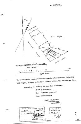 Surveyor-General diagram, B353/1833, August 1833
10TVK501.jpg
 Diagram verso, B353/1833 (verso), 1899
10TVK801.jpg
Cadastre
Surveyor-General diagram index for this parcel
Research notes
[31 Jul 2026 inbox] MIDDELWATER'S NORTHERN NEIGHBOUR - the 1833 diagram is bounded 'South by Middlewater' (DOC-0124). A HALF loan farm, so an existing loan place already split before Stretch surveyed it in Aug 1833; titled 15 Apr 1841 on Bf.W.Q.5-16. Lots A and B went in 1899 as 168/1 and 168/2. THE SHEET NAMES NO HOLDER, which is unusual in this series and is the whole difficulty with the obvious question about the name - see LEAD-0027.
The research behind this page, kept separate from it: dated working notes, open questions, and what is not yet settled.
Open questions
-
Is Venters Kloof named for Adriana Cecilia Venter's family - and did the Oosthuizens follow them to the Koup?
priority 1 · LEAD-0027
Venters Kloof No. 168 lies immediately north of Middelwater No. 169, and the root ancestor Ockert Almero OosthuizenL married ADRIANA CECILIA VENTER. Did her family hold that kloof, and is that why the Oosthuizens ended up on the ground next to it?
What would settle it A Venter named as holder or grantee of No. 168. Equally decisive the other way: a grantee of another surname, which would make the name a fossil of an earlier occupier and kill the family connection.
What the record is missing
-
The record stops in 1875 and never resumes
second order · B2 trail-ends
Venters Kloof No. 168 was worked as far as 1875-07-06, with Maria Christina VenterH (1786-1875) the last owner on record. 151 years follow with nothing. Who held it after that, and is it still one farm?
What would settle it The current title deed traced backwards, each transfer names the one before it, or the Surveyor-General's subdivision diagrams, which are what usually explain a farm going quiet.
Found by breaks.py reading the model against itself, not written by hand,
each one is a shape of missing record, not a fault in the data.
The whole set is on the
questions page.