Part of Klein Valie No. 182
Windwaai (Klein Valie No. 182 Ptn 9)
· on record 1932–1990 · show on the map
The farm's own history, the grant, the original survey, sits on that page.
- Farm number
- No. 182
- Portion
- 9
- District
- Prince Albert
- Extent, as the diagram states it
- 374.8479 morgen
- Modern surveyed area
- 318.9 ha
The historic extent and the modern surveyed area are two separate measurements and are not presented here as confirming each other. The first is what a surveyor wrote on a diagram, usually in morgen. The second is what the modern cadastre draws.
Why this farm is here
S.C. Sooyman (Windwaai, 1933) held it, and no kinship to the Oosthuizen, Marincowitz or Van der Merwe lines is recorded, this ground entered through the land, not the family. 8 km from Klaarstroom.
- parcel Cut out of Klein Valie No. 182
- document A document in the collection describes this ground DOC-0121
- document A document in the collection describes this ground DOC-0122
- lead An open question in this record is about this ground Two parcel_links rows share the id PLK-000019
Before this ground was cut out
This is the history of Klein Valie No. 182, the farm this ground was part of until 1932/1933. It is shown here because this ground was that farm, and separately from what follows because before the cut the record says the farm's name and not which part of it. Not everything below necessarily happened on this piece.
- 1833-08 document SG diagram B348/1833 Bf.W.Q.5-6
- ../1833 ownership Christian Hatting Junior (Klein Valie, 1833) loan farm · survey · confidence high
- ../1878 to 1897 ownership Ockert Almero Oosthuizen (1836-11-27–1922-01-02) owner · confidence medium
- 1878 residence Almero Jacobus Hitge Oosthuizen (1878-01-18–1961-10-29) memoir
- 1892 event The great perdevrekte of 1892 Horse-sickness swept the district: of 95 horses and mules on Kouwveldt (PAR-000088), 14 were left. 'Na hierdie vrekte het die donkie sy tuiste in ons wereld gekry' - the donkey arrived in the Koup's world because the horses died out of it. The diary ranks it with the fall of the ostrich-feather market.
- 1897 event Kouwveldt sold; the family moves to Droogekloof Ockert Almero Oosthuizen sells Kouwveldt - properly Klein Vallei, PAR-000088 - to Jan Muller and moves his household to his other farm, Droogekloof (PAR-000007). The same year the brandsiekwet came from Rhodes; 'die enigste goeie ding wat hy in Suid-Afrika gedoen het', the diary says, with the district protesting.
- 1897 ownership Jan Müller (bought Klein Vallei, 1897) purchase · confidence medium
- 1912 boundary subdivision: becomes Oude Kraal (Klein Valie No. 182 Ptn 1)
- 1912 boundary subdivision: becomes Koude Veld (Klein Valie No. 182 Ptn 2)
- 1912 boundary subdivision: becomes Nieuwe Kraal (Klein Valie No. 182 Ptn 3)
- 1912 boundary subdivision: becomes Gideon's Hoop (Klein Valie No. 182 Ptn 4)
- 1912 boundary subdivision: becomes Groote Leegte (Klein Valie No. 182 Ptn 5)
- 1912-07-30 document survey report 2114-2118/1912 (sketch)
- 1912-07-30 document survey report 2114-2118/1912 (report p1)
- 1912-07-30 document survey report 2114-2118/1912 (report p2)
- 1919 document SG diagram verso B348/1833 (verso)
- 1929 grave Abraham Petrus Muller Kleinvlei farm cemetery, Klein Valie 182
- 1929 grave Catherina Elizabeth Botha Kleinvlei farm cemetery, Klein Valie 182
- 1932/1933 boundary subdivision: becomes Windwaai (Klein Valie No. 182 Ptn 9)
What the record holds, in order
- 1932–1933 boundary change subdivision: from Klein Valie No. 182
-
November 1932
document
SG diagram
T5651/1933
-
7 September 1933
ownership
S.C. Sooyman (Windwaai, 1933)
freehold · transfer · confidence high
- 1990 document SG diagram 6959/90
Also bordered by, as the modern cadastre draws it
Ground that touches this farm on the Surveyor-General's current polygons and that none of the diagrams held here names. Derived from the geometry, not read off a document.
- N Gideon's Hoop (Klein Valie No. 182 Ptn 4)
- NE Kouveld (Klein Valie No. 182 Ptn 6)
- E Groenkraal (Klein Valie No. 182 Ptn 7)
- SE Groote Leegte (Klein Valie No. 182 Ptn 5)
- S Grootleegte (Klein Valie No. 182 Ptn 8)
Documents
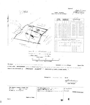 Surveyor-General diagram, deed T5651/1933, November 1932
10849361.jpg
10849364.jpg
Cadastre
Surveyor-General diagram index for this parcel
Surveyor-General diagram index for the whole farm, where the original survey of this ground sits.
Research notes
[31 Jul 2026 inbox] 'WINDWAAI portion of KOUDE VELD' - Portion 9 of Klein Valie, cut out of Portion 2, surveyed Nov 1932 and transferred 7 Sep 1933 to S.C. SooymanH on deed 5651 (DOC-0121). Its antecedent is deed 11089 of 8 Oct 1919 to A.P. Muller J.C. sonM, which is the same deed that carries Oude Kraal and Koude Veld on the 1833 verso - so the 1919 buyer of two of the five pieces was selling out of one of them fourteen years later. AREA CHECK: 374.8479 morgen converts to 321.0 ha against a modern 319.0 - agreement to 0.6%, the closest yet in this model. Two Eskom servitudes crossed it in 1990 (DOC-0122).
[13 Aug 2026] Renamed to the one form this model uses for every portion - the portion's own name, then the parent farm, its number and the portion in brackets - so that a name is legible in a list, a search result and a map popup without the reader having to know which farm number is which. It read "Windwaai (Klein Valie Ptn 9)" before. Nothing about the ground changed.
The research behind this page, kept separate from it: dated working notes, open questions, and what is not yet settled.
Open questions
-
Two parcel_links rows share the id PLK-000019
priority P2 · LEAD-0312
Two different subdivisions carry one link id. Which row keeps PLK-000019, and which is renumbered?
What would settle it Frans's call on which keeps the id. NOT fixed silently: 3 says ids are permanent, so renumbering somebody else's row is a decision, not a tidy-up.
What the record is missing
-
The record stops in 1933 and never resumes
third order · B2 trail-ends
Windwaai (Klein Valie No. 182 Ptn 9) was worked as far as 1933-09-07, with S.C. SooymanH (Windwaai, 1933) the last owner on record. 93 years follow with nothing. Who held it after that, and is it still one farm?
What would settle it The current title deed traced backwards, each transfer names the one before it, or the Surveyor-General's subdivision diagrams, which are what usually explain a farm going quiet.
Found by breaks.py reading the model against itself, not written by hand,
each one is a shape of missing record, not a fault in the data.
The whole set is on the
questions page.