Rondabel
124 op die kadaster · op rekord 1818–2020 · wys op die kaart
- Plaasnommer
- Nr. 124
- Ook aangeteken as
- Rondabelthe original, and the name every document before the twentieth century usesRondawelSRC-436, the modern spelling, which the cadastre and the deeds office now use for Portion 1
- Op die kadaster
- 124, heel plaasgeregistreer as RONDABLE
- Distrik
- Prince Albert
- Moderne opgemete oppervlakte
- 13882.9 ha
Waarom hierdie plaas hier is
Aletta Johanna Oosthuizen se boedel is hier opgeneem. 15 km van Klaarstroom.
Aletta Johanna Oosthuizen is regstreeks op hierdie grond aangeteken. Geen spoor nodig nie.
- storie 'n Geskrewe geskiedenis speel op hierdie grond af On 15 April 1841 loan ground becomes property
- storie 'n Geskrewe geskiedenis speel op hierdie grond af Rondawel's history: from a widow's mark to today's Marincowitz farm
- storie 'n Geskrewe geskiedenis noem hierdie grond Middelwater's story since 1777
- storie 'n Geskrewe geskiedenis noem hierdie grond Vrolykheid's story
- …en nog 2, volledig gelys verder af op hierdie bladsy.
Stories
- about this farm
Op 15 April 1841 word huurgrond plaaseiendom
Een landmeter meet die Koup twee seisoene lank op. Agt jaar later, op een dag, maak die Kroon 'n dosyn leningsplase titelgrond - en die distrik se kaart lê vir 'n eeu vas.
- about this farm
Rondawel se geskiedenis: van 'n weduwee se kruisie tot vandag se Marincowitz-plaas
Van 'n weduwee wat met 'n merk geteken het tot die Marincowitz-plaas van vandag: die gedokumenteerde geskiedenis van Rondabel Nr. 124 - die Venter-huishouding van 1829, die toekenningsdag van 1841, die Oosthuizen-Theron-vennootskap van 1868, die onderverdelings van 1910-34, en die grafte by die opstal, waarvan een nou 'n naam het.
- mentions this farm
Middelwater se storie sedert 1777
Van 'n leningsplaas in die Swartberg tot agt kadastrale persele: die gedokumenteerde geskiedenis van Middelwater Nr. 169 - Stretch se opmeting van 1833 vir Okert Oosthuizen, die toekenningsdag van 1841, die heropmeting van 1883 en die kwitrent van 1884 aan J.D.J. Oosthuysen 'and another', die gedeeltes wat afgesny is vir 'n fontein genaamd Vaste Water en 'n plek genaamd Avondrust, en die kraglynopmeting van 1990 waarvan die koördinate die plaas uiteindelik op 'n kaart gesit het.
- mentions this farm
Vrolykheid se storie
Die plaas waar die papier en die mense verskil. Stretch se opmeting van 1833 dra al klaar die name van gedeeltes wat eers 'n eeu later gesny word; twee titels gaan op een dag in 1841 uit, een aan 'n Oosthuisen en een aan 'n 'N. Hitge' wie se akte deur vier latere gedeeltes aangehaal word; 'n Triëstenaar trou in 1844 met 'n Hitge en hou die plaas toe hy in 1890 sterf; en 'n sterfkennis sit die Hitges uiteindelik self op die grond.
- set here
Twee Vrolykheid-plase, ver van mekaar?
Twee plase met een naam, 400 km uitmekaar. Die Tulbagh-kaart van 1816 noem vier bure; twee van daardie vanne duik in die Koup op en net EEN hou stand as jy behoorlik kyk. Jan de Bruin, wie se boedel in 1823 'n plaas met die naam Rondabel gehou het, is in 1769 op Tulbagh gedoop. Maar die Theron wat Rondabel in 1868 geneem het, was 'n Roggeveld-man, en daardie draad is 'n toeval van vanne wat hier as een aangemeld word.
- about this farm
Minerale onder ons grond
Vier keer het mense hierheen gekom, oortuig dat daar iets van waarde onder die grond lê: goud in 1871 en 1891, olie in die middel-1960's, uraan van 1969 tot 1985, en skaliegas van 2011 af. 'n Boorbeitel lê nog op Rondabel. Die gate wat SOEKOR vir olie geboor het, het die kerne gelewer wat die skaliegasskatting vyftig jaar later laat krimp het.
- mentions this farm
Almero, en hoe dit 'n Oosthuizen-naam geword het, 1786
'n Venesiaanse tiener in die Kompanjie se diens staan in 1786 peetvader by 'n Kaapse doop. Ses geslagte Karoo-boere dra sy naam, en niemand weet meer waarom nie.
- mentions this farm
Die grond gesny, en toe weer aanmekaargewerk
Hierdie projek het 124 grensdade op rekord: 96 onderverdelings en 20 konsolidasies. Gesorteer op datum vertel hulle een storie met 'n draaipunt. Die distrik het honderd-en-vyftig jaar lank net gesny; van 1970 af word net weer aanmekaargewerk.
- mentions this farm
Die woorde uit die bronne, 1753–1971
Elke aanhaling hieronder kom uit 'n dokument in hierdie projek se eie versameling. Niks hier is opgesoek nie; die woordelys was reeds in die papiere.
- mentions this farm
Vier grootouers, vier lande, vanaf 1684
Elkeen van die vier grootouers het sy eie bladsy. Hierdie een gaan oor hoe hulle bymekaargekom het, wat drie troues, vier jaar en een man wat in twee van hulle ingetrou het, gekos het. En oor die titel se belofte: vier lande, waarvan net een op 'n kaart aangewys kan word.
- mentions this farm
Die Oosthuizens van die Koup
Die familie waaroor die rekord hier die diepste loop. Agt geslagte ooswaarts, van 'n soldaat wat in 1685 op Tafelbaai se strand stap tot 'n boer wat in 1909 op Prince Albert gedoop word. 'n Boedelinventaris van 1809 wys 'n smidsvuur op die Olifantsrivier en verklaar meteens waarom die familie weg is: die plaas is aan die oudste seun verkoop, en die res moes grond gaan soek.
- mentions this farm
Die Jouberts en Duminys van die wynland
Drie van Frans se vier grootouers kom uit families wat die droë land ingeloop en daar gebly het. Dit is die vierde, en dit is die vreemde een: 'n lyn wat nooit in die Karoo gewoon het nie. En tog bereik die familie die Prins Albert-distrik drie keer in twee-en-veertig jaar, elke keer deur 'n vrou.
- set here
Twee troues, vyf maande uitmekaar
In October 1807 an Oosthuizen son married a Venter at Swellendam; five months later his brother married a Strydom at Uitenhage, 242 km the other way. Neither was a single marriage - seven of eleven children of one household married into just two families, and married brothers and sisters in both. It is also why Rondabel changed hands three times inside one family network.
Wat die rekord hou, in volgorde
-
2 Mei 1818
document
estate inventory
MOOC8/64.12a
-
2 Mei 1818
estate
Ignatius Michael du Plessis (?–1818), Aletta Elisabeth Dorothea van Heerden
MOOC8/64.12a · loan farm Rondabel, on the Tarka
-
voor 1818 to 1823
ownership
Ignatius Michael du Plessis (?–1818), Jan de Bruin (1769–23 Desember 1822)
loan farm · occupation · confidence medium
-
13 Junie 1823
document
estate inventory
MOOC8/38.12
-
13 Junie 1823
estate
Jan de Bruin (1769–23 Desember 1822), Aletta Johanna Oosthuizen (omstreeks 1775–10 Oktober 1834)
MOOC8/38.12 · loan farm Rondabel, in the Tarka
-
29 Oktober 1829
document
estate inventory
MOOC8/44.48
-
29 Oktober 1829
estate
Jan Adriaan Venter (14 September 1794–23 Julie 1829), Maria Catharina Venter (1783–?)
MOOC8/44.48 · the place Rondavel, field cornetcy of Hermanus van der Westhuisen, Traka, district of Beaufort
-
voor 1829
ownership
Jan Adriaan Venter (14 September 1794–23 Julie 1829), Maria Catharina Venter (1783–?)
loan farm · occupation · confidence high
-
Augustus 1833
document
SG diagram 366/1833
Bf.W.Q.5-2?
-
1841-04-15 to 1868
ownership
David Jan Strydom (Daniel son) (12 Augustus 1798–11 Januarie 1882)
Perpetual Quitrent · grant · confidence high
-
November 1863
document
SG diagram 502/1867
P.A.Q.1-21
-
21 Januarie 1868
ownership
Jan Adriaan Oosthuizen, Stephanus Johannes Theron (3 September 1828–7 Januarie 1879)
Perpetual Quitrent · grant · confidence high
- 17 Julie 1872 boundary change subdivision: becomes Rondawel (Rondabel Nr. 124 Gdlt 1)
-
17 Julie 1872
ownership
Stephanus Johannes Theron (3 September 1828–7 Januarie 1879)
transfer · confidence high
- 10 April 1895 document death notice
-
April 1895
burial
Cecelia Maria du Plessis (9 Januarie 1857–10 April 1895)
Rondabel werf graves, CECILIA MARIA THERON / GEBOREN DU P[LESSIS] / den 9 January 18[illegible] / overleden den 1[?9] April 1895 // Vrome vroeg gestorven vrienden / slechts zij [illegible] / [illegible] zult allen wederom [illegible] / als ons Jezus 't graf ontsluit
-
1901
lived here
Gert Jan Oosthuizen Marincowitz (9 September 1875–8 Oktober 1952)
family testimony
- 1910 boundary change subdivision: becomes Brand Kraal (Rondabel Nr. 124 Gdlt 3)
-
Augustus 1910
document
SG diagram 1654/1910
8326
- 16 September 1910 document beacon report 1654/1910
- 1919 boundary change subdivision: becomes Hartebeest Voedpad (Rondabel Nr. 124 Gdlt 5)
- Januarie 1919 document SG diagram 270/1919
- 1919 document SG diagram 1872-23-208
- 1919 document SG diagram
- 1919 document SG diagram 1872-23-208 (p 2)
- 1919 document SG diagram 1872-23-208 (p 3)
- 1921 boundary change subdivision: becomes Elandsfontein (Rondabel Nr. 124 Gdlt 6)
- 1921 document SG diagram 891/1921
- 1933 boundary change subdivision: becomes Klein Elandsfontein (Rondabel Nr. 124 Gdlt 7)
-
1936
lived here
Frederik Simon Oosthuizen (29 Mei 1856–10 Oktober 1936)
farming · to 1936
-
1968–1973
lived here
Maria Magritha van Rensburg (28 Oktober 1928–3 April 2019)
family testimony
-
1999
lived here
Roy Don Oosthuizen (9 Desember 1923–20 September 1999)
farming · to 1999
-
2003
lived here
Gert Annis Oosthuizen Marincowitz (17 Februarie 1919–4 Julie 2003)
farming · to 2003
-
die 2020s
ownership
Gerhard Jan Oosthuizen Marincowitz (17 Augustus 1946–?), Christiaan Wilhelm Joubert Marincowitz (19 Junie 1949–?)
owner · confidence high
- undated boundary change subdivision: becomes Visgat (Rondabel Nr. 124 Gdlt 2)
- undated boundary change subdivision: becomes Driehoek (Rondabel Nr. 124 Gdlt 4)
- undated boundary change subdivision: becomes Rondabel Nr. 124 Gdlt 8
- undated boundary change subdivision: becomes Rondabel Nr. 124 Restant
- undated document SG diagram verso 502/1867 (verso)
-
undated
burial
Rondabel werf graves
-
undated
burial
Rondabel werf graves
Grond uit hierdie plaas gesny
- Brand Kraal (Rondabel Nr. 124 Gdlt 3) 3.4 ha
- Hartebeest Voedpad (Rondabel Nr. 124 Gdlt 5) 1390.9 ha
- Elandsfontein (Rondabel Nr. 124 Gdlt 6) 2317.0 ha
- Klein Elandsfontein (Rondabel Nr. 124 Gdlt 7) 1300.0 ha
- Rondabel Nr. 124 Restant RE/124 · 3008.9 ha
- Rondawel (Rondabel Nr. 124 Gdlt 1) 3456.0 ha
- Visgat (Rondabel Nr. 124 Gdlt 2) 1800.3 ha
- Driehoek (Rondabel Nr. 124 Gdlt 4) 466.8 ha
- Rondabel Nr. 124 Gdlt 8 139.5 ha
Begrens deur, soos die kaart hulle noem
- E Kopjes Kraal
- N Remhoogte
- N Klip Gat
- E Klip Fontein
- S Government Land
- W Middelwater
- W Remhoogte
- W Droege Kloof (1833 diagram)
Op die afdelingskaart van 1915
Soos die Landmeter-generaal hierdie plaas in 1915 gedruk het: die geregistreerde titelhouer, die datum waarop die titel uitgereik is en die erfpagverwysing, net so van die kaart oorgeskryf. Die hele kaart, plaas vir plaas
| Plaas, soos gedruk | Titelhouer | Titel | Erfpag | Aantekening |
|---|---|---|---|---|
| RONDABLE | J. A. Oosthuizen & another | 21 January 1868 | P.A.Q. 1.21 · fol. 1066 | streams "Knoppies Kraal", "Groot Elands Fontein", "Klein Elands Fontein" marked |
Op hierdie grond begrawe
- Rondabel-werfgrafte 3 grafte opgeteken, 1 in hierdie projek geïdentifiseer
Die begrafnisse verskyn ook op hierdie plaas se tydlyn hierbo, elkeen op sy eie datum.
Ook begrens deur, soos die moderne kadaster dit teken
Grond wat aan hierdie plaas raak op die Landmeter-generaal se huidige poligone en wat geen kaart wat hier gehou word, noem nie. Afgelei uit die meetkunde, nie van 'n dokument afgelees nie.
- N Kalkgat (Klipgat Nr. 114 Gdlt 7)
- NE Kromrivier (Kopjes Kraal Nr. 123 Gdlt 1)
- NE Brand Kraal (Rondabel Nr. 124 Gdlt 3)
- NE Rondawel (Rondabel Nr. 124 Gdlt 1)
- E Kopjes Kraal Nr. 123 Restant
- E Driehoek (Rondabel Nr. 124 Gdlt 4)
- SE Elandsfontein (Rondabel Nr. 124 Gdlt 6)
- SE Klein Elandsfontein (Rondabel Nr. 124 Gdlt 7)
- SE Oorlogs Kloof Nr. 172 (Roode Els Bosch and Oorlogs Kloof)
- S Hartebeest Voedpad (Rondabel Nr. 124 Gdlt 5)
- S Die Kruine Nr. 170
- SW Ebeneser (Middelwater Nr. 169 Gdlt 4)
- SW De Claar Stroom (Klaarstroom Nr. 178)
- SW Rondabel Nr. 124 Restant
- NW Visgat (Rondabel Nr. 124 Gdlt 2)
- NW Rondabel Nr. 124 Gdlt 8
- NW Rhemhoogte Nr. 125 Gdlt 8
- NW Swartskraal (Rhemhoogte Nr. 125 Gdlt 5)
- NW Swartskraal (Rhemhoogte Nr. 125 Gdlt 6)
Dokumente
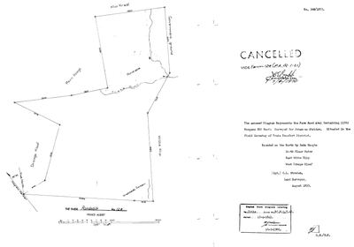 Landmeter-generaal-kaart, 366/1833, Augustus 1833
SCAN329.TIF
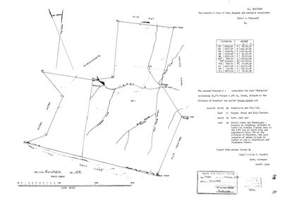 Landmeter-generaal-kaart, 502/1867, November 1863
11025624.TIF
 Kaart se keersy, 502/1867 (verso)
11025627.TIF
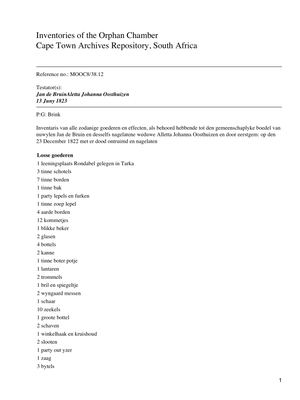 Boedelinventaris, akte MOOC8/38.12, 13 Junie 1823
make_pdf.pdf
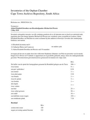 Boedelinventaris, akte MOOC8/64.12a, 2 Mei 1818
make_pdf (2).pdf
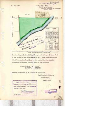 Landmeter-generaal-kaart, 1654/1910, Augustus 1910
10676575 (1).PDF
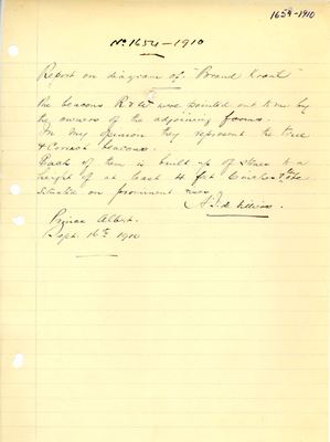 beacon_report, 1654/1910, 16 September 1910
10676576 (1).PDF
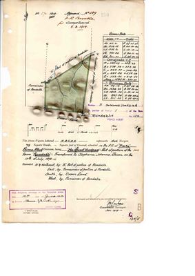 Landmeter-generaal-kaart, 270/1919, Januarie 1919
10747350 (1).PDF
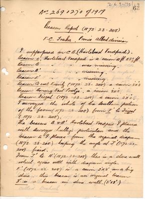 Landmeter-generaal-kaart, 1872-23-208, 1919
10747351-3 (1).PDF
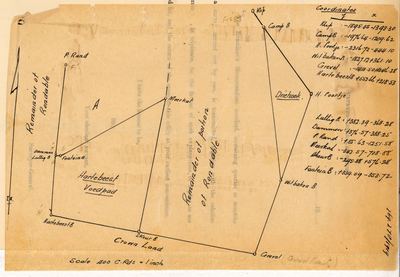 Landmeter-generaal-kaart, 1919
10747354 (1).PDF
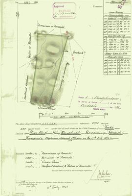 Landmeter-generaal-kaart, 891/1921, 1921
10767696 (2).PDF
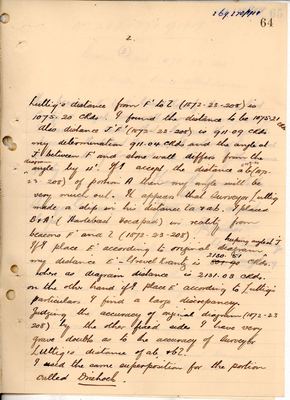 Landmeter-generaal-kaart, 1872-23-208 (p 2), 1919
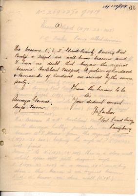 Landmeter-generaal-kaart, 1872-23-208 (p 3), 1919
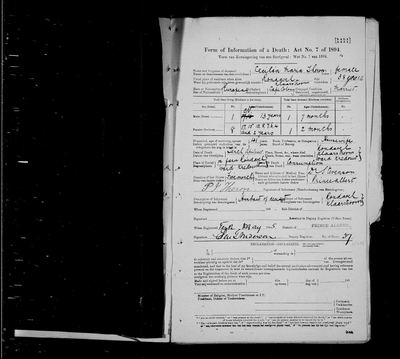 Sterfkennis, 10 April 1895
image (49).jpg
Kadaster
Die Landmeter-generaal se kaartindeks vir hierdie perseel
Navorsingsnotas
GAO Marincowitz line; Rondable No.124; E neighbour of Middelwater [29 Jul 2026] Two unidentified graves near the huis, remembered by Frans from childhood holidays with Tokkie Marincowitz [FAMILY] - GRV-0021/0022, LEAD-0011.
[31 Jul 2026] TWO WERWE, not one. 2 km apart. At 16,646 ha that is unremarkable, but it settles LEAD-0018 - Vischat is on Rondabel, not on Frans Kraal.
[1 Aug 2026, FAMILY] A DRILL BIT lies on this farm, left from exploration drilling. Frans remembers it as French and puts it in the 1950s, 60s or 70s. The documented candidate is SOEKOR, which drilled about twenty deep oil wells across the Karoo in the mid-to-late 1960s and whose 1967 uranium hit started prospecting that ran to 1985 (SRC-184). The 'French' part is unverified and may be an honest slip: the European Southern Observatory's station on Zeekoegat, 40 km away, was the FRENCH team's, and the turn-off is still signposted FRENCH OBSERVATORY. A photograph of the bit's maker's mark would settle it. See LEAD-0051.
[3 Aug 2026, SRC-222] THE ORIGINAL DIAGRAM NUMBER. The 1947 sheet for Gedeelte 8 states that the original diagram for this farm is No. 502/1867, attached to title P.A.Q. 1-21 - the title EVT-000062 records for the 21 January 1868 perpetual-quitrent grant to Jan Adriaan OosthuysenM and Stephanus Johannes TheronL. Surveyed 1867, granted 1868. This project already holds that diagram in full - DOC-0024 the face and DOC-0025 its verso.
[13 Aug 2026, FAMILY] The parent farm keeps RONDABEL. [FAMILY] The original was Rondabel - we cannot change the past. The modern form Rondawel is real and is used for Portion 1 (PAR-000115), by the cadastre and by the 1997 trust; it is recorded there and here as a variant, not as a correction.
[22 Sep 2026, LEAD-0092] The 1818 inventory's 'Rondabel gelegen aan de Tarca' is the EASTERN namesake: its field cornet Stephanus van Wyk is S.J. van Wyk of the Tarka ward, Graaff-Reinet, 1816-1823 (Records of the Cape Colony, SRC-662). It is not this farm's history.
Werknotas, hier gewys omdat dit 'n private navorsingsbou is.
Die werksnotas op hierdie werf word in Engels gehou en word nie vertaal nie. Hulle verander met elke navorsingsessie, en 'n vertaling sou uit pas raak met die oorspronklike. Alles anders - die stories, die getranskribeerde dokumente en die koppelvlak - is in Afrikaans.
Oop vrae
-
The graves at the Rondabel huis - one named, and how many there are is not settled
prioriteit 1 · LEAD-0011
Who lies in the two graves close to the Rondabel farmhouse?
Wat dit sou uitmaak Reading the stones, or a burial entry naming the farm
-
Which Rondabel - Tarka (east) or Traka (Koup)?
prioriteit 1 · LEAD-0014
Do the 1818 du Plessis and 1823 de Bruin inventories ('leeningsplaats Rondabel aan de Tarca / in Tarka') describe the Prince Albert Rondabel No. 124 (PAR-000009), or a namesake loan farm in the eastern-Cape Tarka?
Wat dit sou uitmaak Placing Greyling's or van Wyk's veldkornetskap, or a loan-farm register entry locating the leeningsplaats Rondabel.
-
Which congregation baptised Jan de Bruijn in 1769?
prioriteit 1 · LEAD-0030
The register page (SRC-168) gives the entry in full but not the church. If it is Roodezand/Tulbagh, the de Bruin family is a Tulbagh family and the Vrolykheid name-transfer of LEAD-0010 has a documented carrier. If it is Drakenstein or Swellendam, it does not.
Wat dit sou uitmaak The waypoint. This is a thirty-second lookup, not a research task.
-
The Rondabel du Plessis ARE kin - Martha and Daniel are first cousins
prioriteit 1 · LEAD-0272
MARTHA DU PLESSIS (PER-000750, 1730-1796) married Petrus VenterM on 14 October 1753 and their son is JAN LOUIS VENTER (PER-000120, b.1754) - father of the sixteen Venter children, of whom Adriana Cecilia married the root Oosthuizen and Maria Catharina held Rondabel by 1829. So du Plessis is a DIRECT ANCESTRAL SURNAME one generation above the Venter bloc, and that part is not in doubt. | Two other du Plessis touch the same farm. IGNATIUS MICHAEL DU PLESSIS (PER-000050, d.1818) held HALF THE OPSTAL of a loan farm called Rondabel. CECILIA MARIA DU PLESSIS (PER-001346, 1857-1895) died on Rondabel and is buried there (GRV-0021, DOC-0333). Is either of them kin to Martha, and is Ignatius Michael's Rondabel even the same farm?
Wat dit sou uitmaak A shared father and mother for Daniel and Martha du PlessisM.
-
The Rondavel Venters - parentage, the two Jan Louis Venters, and Wolwekraal
prioriteit 2 · LEAD-0015
(a) Who were Jan Adriaan VenterL's (PER-000350) parents - vernoeming suggests a father named Willem; (b) who are 'Jan Louis VenterL j:r' and 'the widow of Jan Louis VenterL' in the 1829 debts, given the tree kills Johanna Jacomina SmitM in 1824 and a Jan Louis witnesses a baptism in 1837; (c) is the Wolwekraal grantee Johannes Hendrik VenterL (PER-000095) the widow's brother Johannes Henricus (); (d) 8 Nov vs 8 Dec 1823 for Jan Adriaan jr (PER-000096); (e) when did the Venters arrive on Rondavel and how did it pass to the Strydoms by the 1833 survey?
Wat dit sou uitmaak Registers and the two grant/survey files.
-
Where exactly is Vischat / 'fisgat', and what is its real name?
prioriteit 2 · LEAD-0018
Vischat is where Frans's grandfather Hendrik Lodewyk Malherbe OosthuizenM farmed until 1979 and where his father CJJ grew up, yet the model has no ground for it: no extent, no geometry, no ownership row, no document. Which parcel does it actually sit on, and is the name Vischgat/Visgat?
Wat dit sou uitmaak The purchase deed - it will name the parcel Vischat forms part of. Failing that, a topo sheet showing the werf, or CJJ simply saying which farm it was on.
-
Reopen: is the 1818/1823 Rondabel of the inventories ours or an eastern namesake?
prioriteit 2 · LEAD-0092
Were the field cornets Stephanus van Wyk (1818) and Abraham Greyling (1815) Koup wards or eastern Graaff-Reinet wards?
Wat dit sou uitmaak A ward list for Graaff-Reinet and for Beaufort in those years.
-
Three Orphan Chamber inventories put Rondabel 'in the Tarka' and this model pins them to farm 124
prioriteit 2 · LEAD-0183
INV-0001 (MOOC8/64.12a, 1818), INV-0002 (MOOC8/38.12, 1823) and INV-0027 (MOOC8/44.48, 1829) are all linked to PAR-000009, Rondabel No. 124 near Klaarstroom, yet each describes the place as lying in the Tarka or Traka. Is that this Rondabel?
Wat dit sou uitmaak A district named alongside 'Tarka' in the 1818 or 1823 inventory, or a chain of holders running from these estates into the 1841 grantee of farm 124.
-
Who were Cecilia Maria du Plessis's parents - and was Rondabel her own family's ground first?
prioriteit 2 · LEAD-0267
PER-001346, buried at Rondabel in 1895, has NO parents in this model. Two du Plessis holdings of Rondabel sit fifty years apart: Ignatius Michael du PlessisH (PER-000050, d.1818) held it as a LOAN FARM before 1818 with Jan de BruinH (OWN-000025), and Cecilia Maria du Plessis married into the Theron family that was co-granted it in 1868. Is there any descent between them, or is it a coincidence of one of the commonest surnames at the Cape?
Wat dit sou uitmaak Her father's name, and whether he descends from Ignatius Michael du PlessisH.
-
An eleventh child: the daughter of two months on Cecilia Maria Theron's death notice
prioriteit 2 · LEAD-0268
Her death notice of 1895 (DOC-0333) records ELEVEN children - nine living and two dead. This model holds TEN. The form's two deceased are a SON of 7 months and a DAUGHTER of 2 months. The model holds one deceased child, Johannes Gysbert (PER-001169), and no deceased daughter at all. Who was she, and when?
Wat dit sou uitmaak A baptism or burial entry for a Theron daughter of Petrus Jacobus and Cecilia Maria between 1892 and 1895.
-
Two identity questions opened by the Theron kin map: which Jan Adriaan holds Rondabel, and which Venter married into it
prioriteit 2 · LEAD-0269
(1) OWN-000021, the Rondabel quitrent grant of 21 January 1868, is recorded against PER-000046 'Jan Adriaan OosthuizenL', a row with NO dates. Is he Ockert Almero and Adriana Cecilia's son Johannes Adriaan (PER-000003, 1816-1882)? If so the two grantees are brothers-in-law, because the other is Stephanus Johannes TheronL who married that man's sister Dina Magdalena. (2) Isabella Louise Jacoba VenterM (PER-001345, 1875-1939), second wife of Petrus Jacobus TheronL - has she any descent from Adriana Cecilia VenterM's family, or is the surname a coincidence?
Wat dit sou uitmaak (1) The grantee's given names and any age or farm on the 1868 title. (2) Isabella's parents.
-
Martha du Plessis (1730-1796) - who were her parents?
prioriteit 2 · LEAD-0273
She married Petrus VenterM on 14 October 1753 and their son Jan Louis VenterL fathered the sixteen Venter children of STO-0046, three of whom married Oosthuizens and one of whom held Rondabel by 1829. She has no parents recorded here.
Wat dit sou uitmaak Her father's name.
-
Anna Maria Theron, born 13 January 1827 in the Klein Roggeveld - a sister the model does not hold
prioriteit 2 · LEAD-0274
The 1828 register opening that gives Stephanus Johannes TheronL's baptism (SRC-546) carries, immediately above it, ANNA MARIA, born 13 January 1827, same parents - Petrus Jacobus TheronL and Aletta Francina Botma - and the same veldcornetcy, Klein Roggeveld. This model holds only ONE child of that couple: Stephanus Johannes. How many were there, and does any other of them come to the Koup?
Wat dit sou uitmaak The full sibship, and whether any sibling other than Stephanus Johannes turns up on Koup ground.
-
Vischat, Vischgat or Visgat, and where does the name come from?
prioriteit 3 · LEAD-0024
The place is now located (PLC-000034, on Rondabel). What is its actual name, and does any document use it?
Wat dit sou uitmaak Any document or map using the name, or CJJ simply saying it.
-
The drill bit on Rondabel, whose rig, and which of the four searches?
prioriteit 3 · LEAD-0051
There is a drill bit on Tokkie's farm Rondabel (PAR-000009) from exploration drilling, which Frans remembers as French and dates to the 1950s, 60s or 70s. Whose was it?
Wat dit sou uitmaak A photograph of the maker's mark, or a borehole on Rondabel in the national register.
-
Oosthuizen Marincowitz: Rondawel or Koppieskraal, and who was his brother Boy?
prioriteit P2 · LEAD-0344
Two accounts in one book put a man called Oosthuizen Marincowitz on two different farms in the same war. Which was his, and is 'Boy' a fourth Marincowitz this project does not hold?
Wat dit sou uitmaak A baptism or marriage naming the brothers together, or a deed or lease putting a Marincowitz on Koppieskraal.
Wat die rekord kortkom
-
27 years, and the ground changes hands to nobody we can follow
second order · B1 succession
On Rondabel, David Jan StrydomH (Daniel son) is the last owner recorded from 1841-04-15, and the next entry is Jan Adriaan OosthuizenL and Stephanus Johannes TheronL from 1868-01-21, 27 years later, with no person in common. DOC-0186 records the later arrival but not the 27 years before it.
What would settle it The Deeds Office transfer register for this farm between 1841 and 1868. A transfer names its predecessor in title, so one deed closes the whole gap.
Found by breaks.py reading the model against itself, not written by hand,
each one is a shape of missing record, not a fault in the data.
The whole set is on the
questions page.