Rhemhoogte Nr. 125
125 op die kadaster · op rekord 1873–1971 · wys op die kaart
- Plaasnommer
- Nr. 125
- Op die kadaster
- 125, heel plaasgeregistreer as RHEMHOOGTE
- Distrik
- Prince Albert
- Moderne opgemete oppervlakte
- 12288.9 ha
Waarom hierdie plaas hier is
Abel Albertus Oosthuizen het dit gehou. 17 km van Klaarstroom.
Abel Albertus Oosthuizen is regstreeks op hierdie grond aangeteken. Geen spoor nodig nie.
- storie 'n Geskrewe geskiedenis noem hierdie grond Middelwater's story since 1777
- storie 'n Geskrewe geskiedenis noem hierdie grond Oom Frikkie's eighty-one thousand morgen, 1856-1937
- storie 'n Geskrewe geskiedenis noem hierdie grond The war reaches the Koup
- perseel Grond uit hierdie plaas gesny: Annex Modderdrift (Rhemhoogte Nr. 125 Gdlt 3)
- …en nog 2, volledig gelys verder af op hierdie bladsy.
Stories
- mentions this farm
Middelwater se storie sedert 1777
Van 'n leningsplaas in die Swartberg tot agt kadastrale persele: die gedokumenteerde geskiedenis van Middelwater Nr. 169 - Stretch se opmeting van 1833 vir Okert Oosthuizen, die toekenningsdag van 1841, die heropmeting van 1883 en die kwitrent van 1884 aan J.D.J. Oosthuysen 'and another', die gedeeltes wat afgesny is vir 'n fontein genaamd Vaste Water en 'n plek genaamd Avondrust, en die kraglynopmeting van 1990 waarvan die koördinate die plaas uiteindelik op 'n kaart gesit het.
- mentions this farm
Oom Frikkie se een-en-tagtig duisend morg, 1856–1937
Frederik Simon 'Oom Frikkie' Oosthuizen sterf in 1936 met, volgens een weergawe, 81 000 morg om Zwartkraal, omtrent 'n kwart van al die grond op hierdie kaart. Hierdie projek besit nie een akte op sy naam nie. Waarin die geld waarskynlik gesit het, waarin dit beslis nie gesit het nie, en watter een dokument die saak sou uitmaak.
- mentions this farm
Die oorlog bereik die Koup
The Anglo-Boer War came to these farms twice: up the road from Klaarstroom on 2 February 1901, when a running fight through Die Gang left three men dead, a Boer of Scheepers's commando and two British soldiers, and a farmer buried all three; and quietly in 1903, when a woman from Tulbagh married into a Prince Albert family having lost two brothers in Natal thirty-four days apart.
Wat die rekord hou, in volgorde
- 1873 document SG diagram verso 861/1873 (verso)
-
1875
document
SG diagram B.876/1875
P.A.Q.2-20
-
1 Julie 1879
ownership
Abel Albertus Oosthuizen (5 Oktober 1849–22 Junie 1918)
Perpetual Quitrent · grant · confidence medium
-
2 Februarie 1901
event
Johannes Kleu (d. 1901, Remhoogte) (omstreeks 1878–2 Februarie 1901)
[SRC-010, Rose Willis Klaarstroom cameo. TERTIARY, TO VERIFY] The Boers caught the retreating Yeomanry at REMHOOGTE, a farmstead beside the old Prince Albert road, and shot the horses from under them. Lance-Corporal J. Boyd, wounded, sheltered at Wolwekloof; Johannes Kleu, a 23-year-old unarmed rebel walking home to Aberdeen, stumbled on him and was shot dead. That night Scheepers's men stayed at BLOEMENDAL. On 5 February they slipped north across the Witteberg via Boesmanskloof, SLEUTELFONTEIN and BOTTERSKRAAL, reaching ZEEKOEGAT on 7 February and looting two shops. Four of those farms are in this model. || *** [7 Sep 2026, SRC-172 pp.11-13 and SRC-632] THE FARM IS SETTLED AND THE FAMILY IS NAMED. *** Two patrols out of Prince Albert under Capt. McDowell and Lt. Torrane rode towards Klaarstroom on 2 February, took three Boer scouts on the way, saw how many Boers held the village and turned back. 'The Boers gave chase and NEAR THE FARM REMHOOGTE began to close in.' Eight of the Yeomanry were taken with their horses shot under them; Sgt.-Maj. Jackson and Tpr. Mobsby dismounted under fire to get Col. Parke back into the saddle and Jackson was captured doing it; Corp. Boyd was fatally wounded. JOHANNES KLEU DIED IN THE HOUSE. p.13: he 'was seriously wounded and was left behind with the Du Plessis family at Remhoogte'. The family's own account is SRC-632, from Miemie de Wit (PER-002051), who was ten and in the house: the wounded Englishman hid in Wolwekloof, Kleu came upon him, and the Englishman shot him at point blank range through the chest. Her father ROELOF DU PLESSIS (PER-002050) carried him in through the back door and laid him in the room at the far end of the stoep, where he died, and buried him quietly that night. WHICH REMHOOGTE: THE QUESTION FLAGGED ON THIS ROW IS ANSWERED, AND IT IS REIM HOOGTE No. 167. The book states the distance twice and from two different informants - p.36, Anna Snyders: 'the farm Remhoogte, 40 km from Prince Albert on the Klaarstroom road'; p.45, of the grave: 'Forty kilometers from Prince Albert on the farm Remhoogte'. Measured against this project's own cadastre, Reim Hoogte No. 167 (PAR-000092) lies 36.9 km from Prince Albert in a straight line, which is about 40 km by road; Rhemhoogte No. 125 (PAR-000068) lies 46.3 km in a straight line, which cannot be 40 km by road. The grave's own coordinate, which came from eGGSA and not from the book, already sat on 167. Three independent things agree, so the affair belongs on Reim Hoogte No. 167 and the cameo's filing under Rhemhoogte No. 125 is wrong. BOYD WAS BURIED BESIDE HIM AND DID NOT STAY. p.13: 'Boyd was also buried at Remhoogte but after the war his remains were reinterred in the graveyard of the Anglican Church of the Good Shepherd at Klaarstroom.' Miemie de Wit watched it: he 'was buried 50 yards from the Boer. After the war his wife in England asked that he be reinterred. I can well remember the grave being opened.'
- 1931 boundary change subdivision: becomes Annex Modderdrift (Rhemhoogte Nr. 125 Gdlt 3)
- 1937 boundary change subdivision: becomes Kareemoerhoek (Rhemhoogte Nr. 125 Gdlt 4)
-
1948
burial
Barend Cornelius Vry _1 Diedericks
Zwartskraal farm cemetery, Rhemhoogte 125
-
1948
burial
Barend Cornelius Vry _2 Diedericks
Zwartskraal farm cemetery, Rhemhoogte 125
-
1954
burial
Jan Vreek Visagie
Zwartskraal farm cemetery, Rhemhoogte 125
- 1971 boundary change consolidation: becomes Swartskraal (Rhemhoogte Nr. 125 Gdlt 5)
Grond uit hierdie plaas gesny
- Annex Modderdrift (Rhemhoogte Nr. 125 Gdlt 3) 2037.2 ha
- Kareemoerhoek (Rhemhoogte Nr. 125 Gdlt 4) 1561.1 ha
- Rhemhoogte Nr. 125 Gdlt 1
- Groot Sleutelfontein (Rhemhoogte Nr. 125 Gdlt 2) 381.1 ha
- Rhemhoogte Nr. 125 Gdlt 8 4785.4 ha
- Swartskraal (Rhemhoogte Nr. 125 Gdlt 5) 11128.2 ha
- Swartskraal (Rhemhoogte Nr. 125 Gdlt 6) 4779.8 ha
- Rhemhoogte Nr. 125 Gdlt 7 5.6 ha
Op die afdelingskaart van 1915
Soos die Landmeter-generaal hierdie plaas in 1915 gedruk het: die geregistreerde titelhouer, die datum waarop die titel uitgereik is en die erfpagverwysing, net so van die kaart oorgeskryf. Die hele kaart, plaas vir plaas
| Plaas, soos gedruk | Titelhouer | Titel | Erfpag | Aantekening |
|---|---|---|---|---|
| REMHOOGTE | J. A. & J. D. Oosthuysen | 1st July 1879 | P.A.Q. 2.20 · fol. 991 |
Op hierdie grond begrawe
- Zwartskraal-plaasbegraafplaas, Rhemhoogte 125 3 grafte opgeteken
Die begrafnisse verskyn ook op hierdie plaas se tydlyn hierbo, elkeen op sy eie datum.
Ook begrens deur, soos die moderne kadaster dit teken
Grond wat aan hierdie plaas raak op die Landmeter-generaal se huidige poligone en wat geen kaart wat hier gehou word, noem nie. Afgelei uit die meetkunde, nie van 'n dokument afgelees nie.
- N Modderdrift Nr. 106
- N Trakasdrif (Modderdrift Nr. 106 Restant)
- N Modderdrift Nr. 106 Gdlt 4
- N Modderdrift Nr. 239
- N Swartskraal (Rhemhoogte Nr. 125 Gdlt 5)
- NE Annex Modderdrift (Rhemhoogte Nr. 125 Gdlt 3)
- NE Klipgat Nr. 114
- NE Kalkgat (Klipgat Nr. 114 Gdlt 7)
- NE Rhemhoogte Nr. 125 Gdlt 8
- E Rondabel
- E Rondawel (Rondabel Nr. 124 Gdlt 1)
- E Visgat (Rondabel Nr. 124 Gdlt 2)
- E Rondabel Nr. 124 Gdlt 8
- E Swartskraal (Rhemhoogte Nr. 125 Gdlt 6)
- SE Rondabel Nr. 124 Restant
- S Middelwater
- S Middelwater Nr. 169 Gdlt 3
- SW Kareemoerhoek (Rhemhoogte Nr. 125 Gdlt 4)
- SW Middelwater Nr. 169 Gdlt 1
- SW Reim Hoogte Nr. 167
- W Groot Sluitel Fontein Nr. 126
- W Noorsdoringkop (Groot Sluitel Fontein Nr. 126 Gdlt 1)
- W Klein Sleutlefontein Nr. 127
- W Bloemendal Annex Nr. 164
- W Groot Sleutelfontein (Rhemhoogte Nr. 125 Gdlt 2)
- NW Kleinbotterkraal (Klein Sleutlefontein Nr. 127 Gdlt 1)
Dokumente
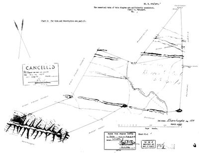 Landmeter-generaal-kaart, B.876/1875, 1875
SCAN335 Rhemhoogte.jpg
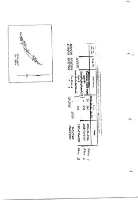 Kaart se keersy, 861/1873 (verso), 1873
10TRF301.jpg
Kadaster
Die Landmeter-generaal se kaartindeks vir hierdie perseel
Navorsingsnotas
MIDDELWATER'S NORTHERN NEIGHBOUR - the "Remhoogte" on the 1883 Middelwater diagram's north boundary and the 1915 registry map. THREE Remhoogte-named farms exist in the division: this No.125, Reim Hoogte No.167 (Middelwater's WESTERN neighbour, DOC-0070/0071), and Rhemhoogte No.8 in the Gouph (DOC-0083) - never conflate them. Farm diagram B.876/1875 (DOC-0082, part 1 held; part 2 with the data NOT yet held). Granted 1.7.1879, deed P.A.Q.2-20, to "(J.)A.A. Oosthuysen & another" (OWN-000060) - THE OOSTHUIZEN FARM NORTH OF MIDDELWATER. Neighbours per the 1875 face: Groot/Klein Sleutel Fontein, Middel Water, Rondavel, Modderdrift, Zoutwater, Klipgat; Traka River the boundary through it. Whole-farm diagram cancelled vide farm 125/5 (CCT 7856/72). Extent not yet read (on part 2).
[SRC-010, Rose Willis Klaarstroom cameo. TERTIARY, TO VERIFY] THE AFFAIR AT REMHOOGTE, 2 Feb 1901: the Boers caught the retreating Imperial Yeomanry here; Johannes KleuH (PER-000518) was shot and died in the farmhouse; the owner is given as 'R DU PLESSIS' and his daughter MIEMIE DU PLESSIS, then ten, remembered it. We hold no owner for this farm in 1901. Judy Maguire's 'Prince Albert and the Anglo Boer War: The Affair at Wolwekraal, Remhoogte' (Prince Albert Museum, 2021) is the study of it.
[3 Aug 2026, SRC-207] THE GRANTEES ARE NAMED. Diagram 978/1883 for Portion 1 describes it as "being one-half of the farm RHEMHOOGTE granted to Mess[rs] J AND J A OOSTHUYSEN on the 1st July 1879". This row and OWN-000060 have carried that grant as '(J.)A.A. Oosthuysen & another'. The 'another' is a second OOSTHUYSEN - two men of the same surname took the farm together. [TO VERIFY which J and which J.A.]
[SRC-325, 7 Aug 2026] A FARM CEMETERY IS RECORDED ON THIS GROUND BY eGGSA: 'Rhemhoogte 125, Zwartskraal', Cemetery ID 7838, at -33.175800, 22.541050. Photographs and captions at https://graveswcape.eggsa.org/PRINCE-ALBERT-Rural/Rhemhoogte-125/ - linked, not copied.
[9 Aug 2026] WHY THE PORTIONS OF THIS FARM DO NOT ADD UP, AND HOW FAR THAT GETS US. checks.py reports farm 125's portions summing to 23,654.4 ha against this row's 12,288.9, which is 92.5% over. Reading DOC-0177 removes the largest part of it: GEDEELTE 8 IS GEDEELTE 6 AND GEDEELTE 7 COMPILED INTO ONE FIGURE, 4728,2437 + 4,6475 = 4732,8912 exactly, so about 4,785 ha is in the sum twice. Drop it and the portions come to 18,869.0 ha, still 53.5% over. THE LIKELY REST OF THE ANSWER IS THAT THIS ROW IS THE REMAINDER, NOT THE WHOLE FARM. That is exactly what Klaarstroom No. 178 turned out to be (PAR-000097): its extent_text was the farm before the resurvey and its sg_area_ha was the Remainder the resurvey left, 30% apart. Not proven here. [TO VERIFY] against the original grant extent for Rhemhoogte and the deduction table on B.876/1875 (DOC-0082).
Werknotas, hier gewys omdat dit 'n private navorsingsbou is.
Die werksnotas op hierdie werf word in Engels gehou en word nie vertaal nie. Hulle verander met elke navorsingsessie, en 'n vertaling sou uit pas raak met die oorspronklike. Alles anders - die stories, die getranskribeerde dokumente en die koppelvlak - is in Afrikaans.
Oop vrae
-
match_cadastre.py no longer reproduces the geometry on disk
prioriteit 1 · LEAD-0017
Re-running match_cadastre.py against the current CSVs changes 11 parcels and does not reproduce what is in parcels.csv. Which is right?
Wat dit sou uitmaak Deciding per parcel whether the script's match or the hand entry is correct, then either fixing the script's name-matching or recording the hand values as deliberate.
-
Where did Frikkie's money come from
prioriteit 2 · LEAD-0012
What built Frederik Simon OosthuizenM's (PER-000006) 81,000-morgen fortune around Zwartkraal?
Wat dit sou uitmaak The 1936 estate inventory - it would list every farm with its purchase deed, date and value, i.e. the whole accumulation history in one document
-
Is Arthur Kleu the painter one of the Kleus of Klueplaas? And is Kleu the same surname as Klue?
prioriteit 3 · LEAD-0125
Frans holds a painting of MEIRINGSPOORT by ARTHUR LIONEL KLEU (1915-2008), a shopkeeper, inherited from his grandfather. Middelwater carries the werf name KLUEPLAAS. Are they one family, and are Kleu and Klue one surname?
Wat dit sou uitmaak A common ancestor, or a Kleu/Klue baptism at Prince Albert or Klaarstroom in the nineteenth century that ties either line to the district.
Wat die rekord kortkom
-
The record stops in 1879 and never resumes
second order · B2 trail-ends
Rhemhoogte Nr. 125 was worked as far as 1879-07-01, with Abel Albertus OosthuizenH the last owner on record. 147 years follow with nothing. Who held it after that, and is it still one farm?
What would settle it The current title deed traced backwards, each transfer names the one before it, or the Surveyor-General's subdivision diagrams, which are what usually explain a farm going quiet.
Found by breaks.py reading the model against itself, not written by hand,
each one is a shape of missing record, not a fault in the data.
The whole set is on the
questions page.