Modderdrift No. 106
· on record 1833–1874 · show on the map
- Farm number
- No. 106
- District
- Prince Albert
- Extent, as the diagram states it
- 9,399 morgen 70 sq roods (1874 resurvey); 7,545 morgen (1833)
- Modern surveyed area
- 8060.0 ha
The historic extent and the modern surveyed area are two separate measurements and are not presented here as confirming each other. The first is what a surveyor wrote on a diagram, usually in morgen. The second is what the modern cadastre draws.
Why this farm is here
Casper van Zyl (1781-1863) held it. Connected to the Oosthuizen, Marincowitz or Van der Merwe lines BY MARRIAGE, not by blood, 2 steps on the shortest path. 25 km from Klaarstroom.
- Casper van Zyl (1781-1863)
- parent of Jacobus Stephanus van Zyl
- married to Susanna Catharina Oosthuizen (b.1811)
Each step is a recorded parentage or marriage in this model, and the shortest one the record supports, follow the names to check it.
- parcel Ground cut out of this farm: Trakasdrif (Modderdrift No. 106 Remainder)
- parcel Ground cut out of this farm: Modderdrift No. 106 Ptn 1
- parcel Ground cut out of this farm: Modderdrift No. 106 Ptn 4
- border Shares a boundary with Zeekoegate Zeekoegate
- …and 2 more, listed in full further down this page.
What this farm became
This ground was cut into portions on a date the record does not give.
- undated Modderdrift No. 106 Ptn 1
- undated Modderdrift No. 106 Ptn 4
- undated Trakasdrif (Modderdrift No. 106 Remainder)
What the record holds, in order
-
August 1833
document
SG diagram 371/1833
D/G Bf.W.Q. 5-45
-
about 1833
ownership
Casper van Zyl (1781-1863) (1781–1863)
loan farm · survey · confidence medium
-
July 1874
document
SG diagram 1978/1875 (877/1875 struck)
P.A.2-21
- undated boundary change subdivision: becomes Modderdrift No. 106 Ptn 1
- undated boundary change subdivision: becomes Modderdrift No. 106 Ptn 4
- undated boundary change subdivision: becomes Trakasdrif (Modderdrift No. 106 Remainder)
Ground cut out of this farm
- Trakasdrif (Modderdrift No. 106 Remainder) RE/106 · 2613.1 ha
- Modderdrift No. 106 Ptn 1 378.7 ha
- Modderdrift No. 106 Ptn 4 5068.2 ha
Bordered by, as the diagram names them
- N Zee Koe Gate (1833) / Zeekoegat and Zoutwater (1874)
- S Reim Hoogte (1833) / Rhemhoogte (1874)
- E Reim Hoogte (1833) / Rhemhoogte (1874)
- W Klein Sleutel fontein
- W Government ground (1833), granted out by 1874 as Jansens and Carolus's Kraal
Also bordered by, as the modern cadastre draws it
Ground that touches this farm on the Surveyor-General's current polygons and that none of the diagrams held here names. Derived from the geometry, not read off a document.
- N Modderdrift No. 106 Ptn 1
- E Annex Modderdrift (Rhemhoogte No. 125 Ptn 3)
- E Klipgat No. 114
- E Modderdrift No. 239
- SE Rhemhoogte No. 125 Ptn 8
- SE Swartskraal (Rhemhoogte No. 125 Ptn 6)
- S Trakasdrif (Modderdrift No. 106 Remainder)
- S Swartskraal (Rhemhoogte No. 125 Ptn 5)
- SW Kleinbotterkraal (Klein Sleutlefontein No. 127 Ptn 1)
- SW Modderdrift No. 106 Ptn 4
- W Farm 236
- W Farm 237
- NW Jansenskraal No. 104
- NW Farm 222
Documents
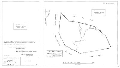 Surveyor-General diagram, 371/1833, August 1833
SCAN595 modderdrift 1.jpg
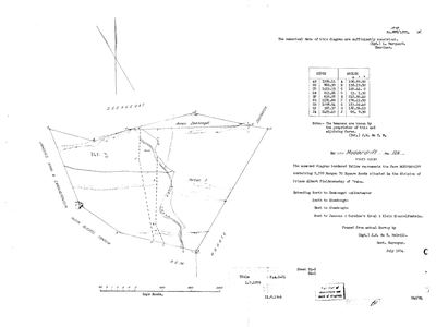 Surveyor-General diagram, 1978/1875 (877/1875 struck), July 1874
10J85S01 modderdrift 2.jpg
Research notes
[1 Aug 2026 inbox] Traka field cornetcy, division of Prince Albert. Two diagrams held. STRETCH, AUGUST 1833 (SG Dgm 371/1833, DOC-0153): 7,545 morgen surveyed for CASPER VAN ZYLE SENIOR, Field Cornetcy of Traka, Beaufort District, copied from the diagram relating to D/G Bf.W.Q.5-45. Bounded N by Zee Koe Gate, S and E by Reim Hoogte, W by Government ground and Klein Sleutel fontein. The sheet names the Kouka River, the Traka, Blauw Kranse and the Modderdrift homestead. Cancelled 18.11.1966, superseded by Dgm 877/1875. MELVILL, JULY 1874 (SG Dgm 877/1875, DOC-0154): 9,399 morgen 70 square roods, division of Prince Albert, examiner L. MarquardM, title P.A.2-21 dated 1.7.1879. Bounded N to Zeekoegat and Zoutwater, S and E to Rhemhoogte, W to Jansens and Carolus's Kraal and Klein Sleutelfontein; Annex Zeekoegat, a House and a Portion 2 are drawn on it. TWO THINGS THE PAIR SHOWS. The farm grew by about 1,854 morgen between 1833 and 1874, which is the annexure of ground rather than a boundary dispute on the face of it [TO VERIFY]. And the WESTERN neighbour changes from 'Government ground and Klein Sleutel fontein' to 'Jansens and Carolus's Kraal and Klein Sleutelfontein', so the Government ground on that side had been granted out in between; Jansenskraal is PAR-000058's parent. WHY IT IS HERE: it sits between Zeekoegat (PAR-000013) and Rhemhoogte (PAR-000068), both tracked, and the model already carries PAR-000069 'Annex Modderdrift' as a Rhemhoogte portion without the parent farm being present. NO GEOMETRY: not yet matched to the cadastre. [1 Aug 2026]
NO WHOLE-FARM POLYGON, and the reason is a defect in the cadastre extract rather than in this model. The key W052C061000000000106000000 appears TWICE in the farms layer, on two features with DIFFERENT areas, 378.8 ha and 2,614.0 ha, and neither is the whole farm. Both are duplicates of portions: 2,614.0 is RE/106 and 378.8 is 1/106. The real farm is the three portions together, RE 2,614.0 + 1/106 378.8 + 4/106 5,069.9 = 8,062.7 ha, against this sheet's 9,399 mg 70 sr = 8,050.5 ha. THAT IS A 0.15% AGREEMENT and it is the best corroboration in the model that the 1874 resurvey and the modern cadastre describe the same ground. The parent therefore carries NO pin, per 5, and the three portions are tracked as their own rows. [2 Aug 2026] WHY THERE IS NO WHOLE-FARM POLYGON, established rather than assumed: the cadastre's farms layer DOES carry W052C061000000000106000000 for Modderdrift 106, but at 378.8 ha - the same geometry as portion 1, not the ~8,050 ha the farm actually is. So the whole-farm entry is unusable rather than absent, and NO-POLYGON is the right call. The farm is drawn by its three portions (PAR-000123/124/125), which sum to 8,062.7 ha. SEPARATE TRAP: Prince Albert has a SECOND farm called MODDERDRIFT, No. 239 (7,126.7 ha, with its own RE and Portion 1). It is not this farm and the two must never be pooled - same class of error as the two Middelwaters and the two Vrolykheids. [2 Aug 2026, CORRECTED SAME DAY] An earlier note on these rows said about 5,070 ha had LEFT farm 106. That was wrong, and the diagram DOC-0154, the 1874 resurvey by J.W. du T. MelvillM, gives the farm as 9,399 morgen 70 square roods = 8,050.6 ha. RE/106 (2,614.0) + Ptn 1 (378.8) + Ptn 4 (5,069.9) = 8,062.7 ha - a 0.15% fit. THE THREE PIECES ARE THE FARM. Portion 4 carries WSTATUS='H' in the cadastre, so it is not a CURRENT parcel, but its geometry is the correct historical geometry and on a history site that is the geometry worth drawing. It is now pinned deliberately and marked geo_match='pinned-superseded'. [2 Aug 2026] NOW DRAWN, COMPOSED FROM ITS OWN PORTIONS. Right — the map drew the three portions and never the farm, while DOC-0154 shows ONE closed figure, beacons A to J. The cadastre cannot supply that outline (its whole-farm entry for 106 is published at 2,614 ha and again at 378.8 ha, which are the remainder and portion 1, not the farm), so the farm is assembled from RE/106 + Ptn 1 + Ptn 4. WHAT THAT IS AND IS NOT: it is the correct SET of ground — 8,062.7 ha against the 1874 resurvey's 9,399 morgen 70 sq roods = 8,050.6 ha, a 0.15% fit, and the placement agrees with the diagram's own boundary statements (N to Zeekoegat and Zoutwater, S and E to Rhemhoogte, W to Jansens & Carolus's Kraal and Klein Sleutelfontein). It is NOT the 1874 BOUNDARY: internal lines are not dissolved, and where a portion was later re-cut the composed edge follows today's cut rather than the surveyor's. Marked geo_match='composed' so a page can say which it is. NOTE ALSO that the 1874 sheet's own internal labels are 'Portion 2', a handwritten 'PTN 3' and 'REM' — today's parcels are RE, 1 and 4, so the farm was re-subdivided at some point between. [TO VERIFY] against the verso deduction list, which is not held.
[3 Aug 2026, SRC-204] INDEPENDENT CONFIRMATION OF THE COMPOSITION. The 2003 diagram for farm 222 (DOC-0170) names as its neighbours both 'Gedeelte 1 van MODDERDRIFT NR 106' and 'Restant van MODDERDRIFT NR 106' - two separate parcels under farm number 106, which is precisely the structure this row was composed from (PAR-000124 Ptn 1 and PAR-000123 RE). A surveyor drawing the boundary in 2003 saw the same division of farm 106 that the cadastre publishes and that this project assembled the farm out of.
[3 Aug 2026, SRC-210] THE 'SECOND MODDERDRIFT' TRAP IS DISSOLVED, and the note above should be read with this. Farm 239 is NOT a namesake of this farm. It is a 2016 consolidation of GEDEELTE 4 OF THIS FARM (PAR-000125) and Gedeelte 3 of Rhemhoogte 125 (PAR-000069) - see PAR-000141. It is called Modderdrift because five-sevenths of it IS Modderdrift 106. The caution was right in method and wrong in fact: 106 and 239 must still never be POOLED as if one farm, but they are parent and descendant, not two farms that happen to share a name. The two Middelwaters remain a genuine namesake case; this one is not.
[3 Aug 2026, SRC-211] A PIECE MAY BE MISSING FROM THE COMPOSITION. The 1977 diagram for Rhemhoogte Ged 8 names "Gedeelte 2 van Modderdrift Nr. 106" as a neighbour. This farm is composed from the Remainder, Portion 1 and Portion 4 only (PAR-000123/124/125) - there is no Portion 2 in the model, and the cadastre extract did not offer one. The 1874 resurvey DOC-0154 ALSO draws 'a Portion 2' on its face, which this row already noted without following up. Two independent documents therefore say Portion 2 exists. The 0.15% area agreement of RE+1+4 against the 1874 survey argues it was small or was later re-absorbed, but that is reasoning, not evidence. [TO VERIFY - the deduction table on the verso of the 1874 sheet would settle it, and it is not held]
[3 Aug 2026, SRC-214] AND A THIRD MISSING PORTION. The 2016 diagram for Farm 236 names "Portion 3 of the farm MODDERDRIFT No. 106" as a neighbour. With the Gedeelte 2 named on SRC-211 and SRC-213, that is now PORTIONS 2 AND 3 of this farm attested by documents and absent from this model, which holds only the Remainder, Portion 1 and Portion 4. Four independent sheets across 1874, 1971, 1977 and 2016 describe a farm 106 with more pieces than we have. The 0.15% area agreement of RE+1+4 against the 1874 survey is still the strongest thing we have and it argues those two were small or later re-absorbed - but that is inference, and the composition should now be treated as PROBABLY INCOMPLETE rather than settled. [TO VERIFY]
The research behind this page, kept separate from it: dated working notes, open questions, and what is not yet settled.
Open questions
-
Is Modderdrift's "Casper van Zyle Senior" the Casper van Zyl of the Beaufort West baptisms?
priority 1 · LEAD-0056
Is the Casper van ZylHe Senior for whom Modderdrift No. 106 was surveyed in 1833 the same man as Casper van ZylH (1781-1863), father of the two van Zyl brothers baptised at Beaufort West?
What would settle it A death notice or estate inventory listing Modderdrift among his property, or a title deed giving his full names. Either settles it in one line.
-
Three van Zyl landholdings in this district, and whether they connect
priority 1 · LEAD-0057
Are Casper van ZylHe Senior of Modderdrift No. 106 (1833), Lucas Daniel Fromon van Zyl of Klipgat No. 114 (d. by 1911), and the Brandfort van Zyls of S018 one family?
What would settle it A death notice or estate account that puts two of these three men in one descent. Ten named heirs from the 1916 deeds would be the fastest route, because ten names are far easier to match against the tree than one.
-
1,302 cadastre keys carry more than one polygon, of different sizes
priority 2 · LEAD-0060
Is PRCL_KEY safe to use as a unique identifier in the Western Cape extract, and if not, what is?
What would settle it Either a rule that picks the right feature deterministically (PRCL_TYPE F vs FP already does most of it), or confirmation from the Surveyor-General that the extract has duplicates.
-
What superseded Modderdrift Portion 4?
priority 2 · LEAD-0063
Modderdrift No. 106's Portion 4, 5,069.9 ha, carries WSTATUS='H' in the cadastre - superseded. Its geometry is right: RE + Ptn 1 + Ptn 4 reconstruct the 1874 resurvey (9,399 morgen 70 sq roods = 8,050.6 ha) to 0.15%. So the question is not where the ground went - it is what replaced Portion 4 as the current parcel over that ground, and when.
What would settle it The deduction list on the VERSO of DOC-0154 - the diagram says so itself: 'For list of deductions see back of diagram'. Frans holds the front; the back is the sheet that answers this.
What the record is missing
-
The record stops in 1833 and never resumes
second order · B2 trail-ends
Modderdrift No. 106 was worked as far as 1833~, with Casper van ZylH (1781-1863) the last owner on record. 193 years follow with nothing. Who held it after that, and is it still one farm?
What would settle it The current title deed traced backwards, each transfer names the one before it, or the Surveyor-General's subdivision diagrams, which are what usually explain a farm going quiet.
Found by breaks.py reading the model against itself, not written by hand,
each one is a shape of missing record, not a fault in the data.
The whole set is on the
questions page.