Part of Jansenskraal No. 104
Botterkraal (Jansenskraal No. 104 Ptn 2)
· on record 1841–2017 · show on the map
The farm's own history, the grant, the original survey, sits on that page.
- Farm number
- No. 104
- Portion
- 2
- District
- Prince Albert
- Extent, as the diagram states it
- 3418 morgen
This parcel has no matched survey polygon, so it cannot be drawn on the map. That is a gap in the cadastre match, not an absence from the record.
Why this farm is here
Christian Hatting Senior held it. Connected to the Oosthuizen, Marincowitz or Van der Merwe lines BY MARRIAGE, not by blood, 5 steps on the shortest path. Not yet placed on the map.
- Christian Hatting Senior
- married to Maria Christina Venter (1786-1875)
- child of Willem Venter (b.1761)
- parent of Jan Adriaan Venter
- parent of Willem Venter
- married to Anna Christina Oosthuizen
Each step is a recorded parentage or marriage in this model, and the shortest one the record supports, follow the names to check it.
- story A written history names this ground The aardvark's hole and the Gatsplaas gold rush, 1871-1892
- story A written history is set on this ground Frikkie Oosthuizen builds a church at Zeekoegat, 65 km from town, 1906
- story A written history names this ground The ground cut, and then stitched back together
- story A written history is set on this ground Six graves on Botterkraal, and how a family lost its farm, 1919-1948
- …and 2 more, listed in full further down this page.
Stories
- mentions this farm
The aardvark's hole and the Gatsplaas gold rush, 1871-1892
An aardvark turns up a nugget on Spreeuwfontein in 1871; twenty years later a shepherd finds a second one and five hundred people arrive. 1,042 claims yield 504 ounces. The diggers' village was called Gatsplaas.
- set here
Frikkie Oosthuizen builds a church at Zeekoegat, 65 km from town, 1906
Three generations of Oosthuizens in the Zwartberg church, and the rich farmer who built a chapel 65 km out on the dirt for a hundred people.
- mentions this farm
The ground cut, and then stitched back together
This project holds 124 boundary acts: 96 subdivisions and 20 consolidations. Sorted by date they tell one story with a turning point. The district cut ground for a hundred and fifty years; from 1970 it has only stitched.
- set here
Six graves on Botterkraal, and how a family lost its farm, 1919-1948
A farm cemetery near Zeekoegat holds six burials between 1927 and 1942. Fifteen years, and the whole of what happened to one family, in one fenced plot: the purchase in 1919, ACVV relief, a fence built by hand, nine hundred wethers walked home from Colesberg, and a forced sale in 1943.
- mentions this farm
The war reaches the Koup
The Anglo-Boer War came to these farms twice: up the road from Klaarstroom on 2 February 1901, when a running fight through Die Gang left three men dead, a Boer of Scheepers's commando and two British soldiers, and a farmer buried all three; and quietly in 1903, when a woman from Tulbagh married into a Prince Albert family having lost two brothers in Natal thirty-four days apart.
Who stood on this ground, and how they were related
Everyone the record places here - by deed, by residence, or by burial - and the kinship between each pair of them. Two numbers are given and they are deliberately kept apart. Steps is how far apart two people are in the family graph, counting a marriage as one step. The common ancestor is the nearest one they share by blood, with the year they were born. A pair four steps apart through a couple born in the 1750s is a relationship; a pair ten steps apart through a progenitor born in the 1630s is background, because almost everybody descends from him. Read both.
- 1841 Christian Hatting Senior held 1841-04-15
- 1868 P.H. du Plessis held 1868-11-17 · held 1896-10-08
- 1915 Christiaan Hendrik Swanepoel (b6c5d7e3f7) buried on · lived on 1915 · held 1919-01-23
- 1919 Pieter Johannes Swanepoel (b6c5d7e16f1) held 1919-01-23
- 1927 Christiaan Hendrik Swanepoel jnr (b6c5d7e3f7g5) held 1927-01-27 · lived on 192X · held 1940-10-08
- 1927 Jacobus Johannes Gerrit "Kootjie" Swanepoel buried on · held 1927-01-27
- 1943 Jan Jacobus Adriaan Minie held 1943-06-06
- — Elizabeth "Bettie" Maria Swanepoel (van Eck) lived on 192X
- — Maria Susanna Jacoba van Zyl buried on
| Steps | Between | Nearest common ancestor by blood |
|---|---|---|
| 1 | Christiaan Hendrik Swanepoel (b6c5d7e3f7) · Christiaan Hendrik Swanepoel jnr (b6c5d7e3f7g5) | Frederik Hendrik Swanepoel (b6c5d7e3) born 1827 (1+2 generations up) |
| 1 | Christiaan Hendrik Swanepoel (b6c5d7e3f7) · Maria Susanna Jacoba van Zyl | none within twelve generations |
| 2 | Christiaan Hendrik Swanepoel jnr (b6c5d7e3f7g5) · Maria Susanna Jacoba van Zyl | none within twelve generations |
Drawn from the parentage and marriages this project holds, never from a shared surname. A pair with no common ancestor here may still be related through a link nobody has recorded yet. 3 further pairs are not listed because they are more than six steps apart, which is the distance this page has just told you to discount.
Before this ground was cut out
This is the history of Jansenskraal No. 104, the farm this ground was cut from, on a date the record does not give. It is shown here because this ground was that farm, and separately from what follows because before the cut the record says the farm's name and not which part of it. Not everything below necessarily happened on this piece.
- 1990 boundary consolidation: becomes Farm 215
- 2016 boundary consolidation: becomes Farm 236
- undated boundary subdivision: becomes Botterkraal (Jansenskraal No. 104 Ptn 2)
- undated grave Swanepoel Botterkraal farm cemetery, Jansenskraal 104
What the record holds, in order
-
1841-04-15 to 1868-11-17
ownership
Christian Hatting Senior (1772–1848)
quitrent · grant · confidence high
-
1868-11-17 to 1896-10-08
ownership
P.H. du Plessis
quitrent · transfer · confidence high
-
May 1893
document
SG diagram 1319/1896
Transfer 6578 of 8.10.1896
-
8 October 1896
ownership
P.H. du Plessis
quitrent · transfer · confidence high
-
1915
lived here
Christiaan Hendrik Swanepoel (b6c5d7e3f7) (14 July 1864–14 November 1927)
farming
-
1919-01-23 to 1927-01-27
ownership
Christiaan Hendrik Swanepoel (b6c5d7e3f7) (14 July 1864–14 November 1927), Pieter Johannes Swanepoel (b6c5d7e16f1)
freehold · transfer · confidence high
- 1920 boundary change subdivided_into: becomes Boter Kraal Oost (Jansenskraal No. 104 Ptn 3)
-
the 1920s
lived here
Christiaan Hendrik Swanepoel jnr (b6c5d7e3f7g5) (1893–30 January 1948)
farming
-
the 1920s
lived here
Elizabeth "Bettie" Maria Swanepoel (van Eck) (about 1917–?)
childhood
-
14 November 1927
burial
Christiaan Hendrik Swanepoel (b6c5d7e3f7) (14 July 1864–14 November 1927)
Botterkraal, cement headstone, INSCRIPTION CUT ON THE BACK and now completely unreadable
-
1927-01-27 to 1940-10-08
ownership
Christiaan Hendrik Swanepoel jnr (b6c5d7e3f7g5) (1893–30 January 1948), Jacobus Johannes Gerrit "Kootjie" Swanepoel (28 October 1895–14 November 1939)
freehold · transfer · confidence high
-
17 July 1938
burial
Maria Susanna Jacoba van Zyl (15 April 1866–17 July 1938)
Botterkraal, 15-04-1866 / 17-7-1938
-
December 1938
burial
Louisa Petronella Swanepoel
Botterkraal, 3-8-1925 / 8-12-1938?
-
14 November 1939
burial
Jacobus Johannes Gerrit "Kootjie" Swanepoel (28 October 1895–14 November 1939)
Botterkraal, 28-10-1895 / 14-11-1939
-
August 1940
burial
Maria Susanna Jacoba (Miemie) Swanepoel
Botterkraal, 11-6-1919 / 14-8-1940?
-
1940-10-08 to 1943-06-06
ownership
Christiaan Hendrik Swanepoel jnr (b6c5d7e3f7g5) (1893–30 January 1948)
freehold · transfer · confidence high
-
January 1942
burial
Theodoris Louis van Eck
Botterkraal, 23-07-1940 / Jan 1942 - drowned in a dam on Tierberg, aged 18 months
-
6 June 1943
ownership
Jan Jacobus Adriaan Minie
freehold · transfer · confidence high
- 2016 boundary change consolidation: becomes Farm 237
- 2016 boundary change subdivided_into: becomes Jansenskraal No. 104 Ptn 6
- 2017 document SG diagram verso 1319/1896 (verso)
- undated boundary change subdivision: from Jansenskraal No. 104
Bordered by, as the diagram names them
- W Tierberg (T.L. van Eck)
- · Caroluskraal (Jan Swanepoel)
- · F.S. Marincowitz
- · G. Raubenheimer
- · Estate late P.J. Swanepoel
- · Klein Botterkraal (the Oosthuizens)
Buried on this ground
- Botterkraal 6 graves recorded, 3 identified in this project · no coordinate yet
The burials also appear on this farm's timeline above, each at its own date.
Documents
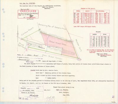 Surveyor-General diagram, 1319/1896, May 1893
11414737
11414738
Research notes
[SRC-072] On the dirt road between Prince Albert and Zeekoegat - in the 1920s and 30s the main road to Willowmore. Bought 23 Jan 1919 out of the estate of the late B.J.L. du PlessisM and three others by "Swanepoel en Swanepoel" (two cousins). Sold 6 Jun 1943 to J.J.A. Minie, the family broken by drought, the Depression and three deaths. THE MINERAL RIGHTS WERE HELD BACK on the strength of the gold found on Spreeufontein - see STO-0002. Farm cemetery of 8 recognisable graves. In 2002 part of Johan Senekal's "Die Meule" farming operation.
[3 Aug 2026, SRC-215] ITS DIAGRAM AND ITS DEED, at last. The 2016 plan for Farm 237 cites this parcel as "Remainder Portion 2 (BOTER KRAAL) of the farm Jansen'skraal No. 104, vide S.G. Diagram No. 1319/1896 annexed to Deed of Transfer No. 1896-6578". Neither number was held here. It also names a sibling this model does not carry - Portion 3, BOTERKRAAL OOST, diagram 13/1920, deed 1920-9891 - so Botterkraal is a pair, west and east, cut twenty-four years apart. Both were consolidated into FARM 237 (PAR-000146) in 2016. [TO VERIFY against the 1896 diagram, which is not held]
*** [4 Aug 2026, LEAD-0084 RESOLVED] THE MATCHER WAS NEVER AT FAULT. *** The polygon for this parcel carries WSTATUS='H' - SUPERSEDED. match_cadastre.py indexes superseded features by their LPI ONLY and keeps them out of the name and farm-number indexes, so nothing automatic can land on one. That is deliberate and documented in the loader: a superseded polygon is reachable by an explicit PIN and by nothing else, because a pin is somebody saying "I know, use this one". For a history site a superseded shape is often the only correct geometry there is - Modderdrift Portion 4 is the precedent. NOT PINNED. The superseded polygon W052C061000000000104000020 exists, but 3 418 morgen = 2 927,6 ha teen die superseded polygon's 1 653,8 ha - 77% APART. That is not the same piece of ground and no pin may be made on it. Recorded rather than resolved: an unplaced parcel is honest, a wrongly placed one is not, and 5 says a wrong pin is worse than a missing one because a map makes a claim look authoritative. [TO VERIFY]
[SRC-315, 7 Aug 2026] A FARM CEMETERY IS RECORDED ON THIS GROUND BY eGGSA: 'Jansenskraal 104, Botterkraal', Cemetery ID 7132, at -33.103267, 22.398717. Photographs and captions at https://graveswcape.eggsa.org/PRINCE-ALBERT-Rural/0721048%20Botterkraal%20in%20distrik%20Prince%20Albert_Pieter%20Olckers/ - linked, not copied.
[13 Aug 2026] Renamed to the one form this model uses for every portion - the portion's own name, then the parent farm, its number and the portion in brackets - so that a name is legible in a list, a search result and a map popup without the reader having to know which farm number is which. It read "Botterkraal (Jansenskraal Ptn 2)" before. Nothing about the ground changed.
[14 Aug 2026 inbox, SRC-438/DOC-0297 + SRC-439/DOC-0298] ITS DIAGRAM AND ITS WHOLE CHAIN. S.G. dgm 1319/1896, surveyed May 1893 by J.A. Thwaits: 3418 morgen, "that portion of Jansens Kraal called BOTER KRAAL", in the FIELD CORNETCY OF GOUPH. Granted to CHRISTIAN HATTING SENIOR on 15 April 1841, folio 1058 - grant day - then to J.G. Daniel and P.H. du PlessisH on 17 November 1868, then to Pieter H. du Plessis on transfer 6578 of 8 October 1896. Bounded NW Lot A Carolus Poort, NE the Remaining portion of Jansens Kraal, S and SW Klein Sluitel fontein and Groot Tygerberg, E Modder Drift.
TWO PORTIONS CAME OFF IT and are now rows here: PAR-000273 Boter Kraal Oost (Ptn 3, 1732 mg 24 sr, 1920) and PAR-000274 (Ptn 6, 1026.357 ha, 2016).
THE TWO EXTENTS ON THE SHEET DO NOT AGREE: the text says 3418 morgen and the beacons table says 3907 morgen 180 square roods. Recorded as a disagreement, not averaged. [TO VERIFY]
CANCELLED as to the Remainder in 2017, vide Farm 237. IT WAS THE HALFWAY STAGE ON THE PRINCE ALBERT POST ROAD, which is a fact about this farm that nothing else here carries. In 1901 Oudtshoorn had no rail link to Cape Town, so the post went over the Swartberg Pass to Prince Albert Road Station, and Jan Haak's eight-mule coach changed teams here. On Wednesday 9 October 1901 Scheepers's men surrounded that coach at Botterkraal, cut open the post bags, took anything of value, burned the rest and seized six of the eight mules, which left the driver unable to go on. There were no passengers. The next day the commando reached Kopjeskraal, which the book puts at 20 km from here, and Scheepers was taken there two days after that. EVT-000325. NOT ADDED TO S025, DELIBERATELY. That story runs 1919 to 1948 and is about the Swanepoels losing this farm; a 1901 aside would dilute it. The fact belongs to the ground rather than to that family.
The research behind this page, kept separate from it: dated working notes, open questions, and what is not yet settled.
Open questions
-
Four portions have a polygon in geo/ that match_cadastre.py still will not pick up
priority 2 · LEAD-0084
Why does the matcher miss PAR-000023, PAR-000058, PAR-000069 and PAR-000144 when their exact PRCL_KEYs are present?
What would settle it Printing the matcher's computed key beside the cadastre key for one of these four.
-
Which Botterkraal was the mail coach taken on
priority 2 · LEAD-0131
The Boers seized the mail coach and horses at Botterkraal, on the road between Prince Albert Road station and the village. Which Botterkraal, and in what month of 1901?
What would settle it A dated report naming the farm.
What the record is missing
-
“G. Raubenheimer” held ground next door and we have no tenure for them
first order · B4 unheld-owner
A boundary description for Botterkraal (Jansenskraal No. 104 Ptn 2) names G. RaubenheimerM, a surveyor stating on the record that this person held the adjoining ground. No one of that surname holds a single ownership span anywhere in this model.
What would settle it The diagram's own date fixes the window. The quitrent or erfpacht register for that year names the holder of the adjoining place, and an estate inventory will name the farm outright.
-
“Tierberg (T.L. van Eck)” held ground next door and we have no tenure for them
first order · B4 unheld-owner
A boundary description for Botterkraal (Jansenskraal No. 104 Ptn 2) names Tierberg (T.L. van Eck), a surveyor stating on the record that this person held the adjoining ground. No one of that surname holds a single ownership span anywhere in this model.
What would settle it The diagram's own date fixes the window. The quitrent or erfpacht register for that year names the holder of the adjoining place, and an estate inventory will name the farm outright.
-
27 years, and the ground changes hands to nobody we can follow
second order · B1 succession
On Botterkraal (Jansenskraal No. 104 Ptn 2), Christian Hatting SeniorH is the last owner recorded from 1841-04-15, and the next entry is P.H. du PlessisH from 1868-11-17, 27 years later, with no person in common. DOC-0297 records the later arrival but not the 27 years before it.
What would settle it The Deeds Office transfer register for this farm between 1841 and 1868. A transfer names its predecessor in title, so one deed closes the whole gap.
-
23 years, and the ground changes hands to nobody we can follow
second order · B1 succession
On Botterkraal (Jansenskraal No. 104 Ptn 2), P.H. du PlessisH is the last owner recorded from 1896-10-08, and the next entry is Christiaan Hendrik SwanepoelH (b6c5d7e3f7) and Pieter Johannes SwanepoelL (b6c5d7e16f1) from 1919-01-23, 23 years later, with no person in common. DOC-0056 records the later arrival but not the 23 years before it.
What would settle it The Deeds Office transfer register for this farm between 1896 and 1919. A transfer names its predecessor in title, so one deed closes the whole gap.
-
The record stops in 1943 and never resumes
third order · B2 trail-ends
Botterkraal (Jansenskraal No. 104 Ptn 2) was worked as far as 1943-06-06, with Christiaan Hendrik Swanepoel jnrH (b6c5d7e3f7g5) the last owner on record. 83 years follow with nothing. Who held it after that, and is it still one farm?
What would settle it The current title deed traced backwards, each transfer names the one before it, or the Surveyor-General's subdivision diagrams, which are what usually explain a farm going quiet.
-
“Estate late P.J. Swanepoel” held ground next door and we have no tenure for them
third order · B4 unheld-owner
A boundary description for Botterkraal (Jansenskraal No. 104 Ptn 2) names Estate late P.J. Swanepoel, a surveyor stating on the record that this person held the adjoining ground. We do hold Swanepoel tenure elsewhere, but none on this boundary and none at this date.
What would settle it The diagram's own date fixes the window. The quitrent or erfpacht register for that year names the holder of the adjoining place, and an estate inventory will name the farm outright.
Found by breaks.py reading the model against itself, not written by hand,
each one is a shape of missing record, not a fault in the data.
1 further, less urgent, on the
questions page.