Zeekoegate
22 on the cadastre · on record 1936–2022 · show on the map
- Farm number
- No. 22
- On the cadastre
- 22, whole farm
- District
- Prince Albert
- Modern surveyed area
- 5711.7 ha
1 entry below names a party who is living, or who cannot be shown to be deceased. The transaction is shown; the name is not.
Why this farm is here
Martha Maria Susanna Oosthuizen is buried here. 32 km from Klaarstroom.
Martha Maria Susanna Oosthuizen is on record on this ground directly. No trace needed.
- story A written history is set on this ground Frikkie Oosthuizen builds a church at Zeekoegat, 65 km from town, 1906
- story A written history is set on this ground The French Observatory at Zeekoegat
- story A written history is set on this ground Oom Frikkie's eighty-one thousand morgen, 1856-1937
- parcel Consolidated into: Farm 222
- …and 2 more, listed in full further down this page.
Stories
- set here
Frikkie Oosthuizen builds a church at Zeekoegat, 65 km from town, 1906
Three generations of Oosthuizens in the Zwartberg church, and the rich farmer who built a chapel 65 km out on the dirt for a hundred people.
- about this farm
The French Observatory at Zeekoegat
Six European countries spend seven years looking for a southern sky and build a working observatory on a Zeekoegat sheep farm, then leave for Chile. The third time the outside world came to this one farm for something it could not get elsewhere - after the gold and the fossils - and the third time the answer was nearly.
- about this farm
Oom Frikkie's eighty-one thousand morgen, 1856-1937
Frederik Simon 'Oom Frikkie' Oosthuizen died in 1936 holding, by one account, 81,000 morgen around Zwartkraal - about a quarter of all the ground on this map. This project holds not one deed in his name. What the money was probably in, what it was certainly not in, and the one document that would settle it.
Who stood on this ground, and how they were related
Everyone the record places here - by deed, by residence, or by burial - and the kinship between each pair of them. Two numbers are given and they are deliberately kept apart. Steps is how far apart two people are in the family graph, counting a marriage as one step. The common ancestor is the nearest one they share by blood, with the year they were born. A pair four steps apart through a couple born in the 1750s is a relationship; a pair ten steps apart through a progenitor born in the 1630s is background, because almost everybody descends from him. Read both.
- — Frederik Simon Oosthuizen buried on
- — Martha Maria Susanna Oosthuizen buried on
- — Hendrik Jacobus Oosthuizen (infant, 1883-1884) buried on
| Steps | Between | Nearest common ancestor by blood |
|---|---|---|
| 1 | Martha Maria Susanna Oosthuizen · Hendrik Jacobus Oosthuizen (infant, 1883-1884) | Anna Margaretha Van Jaarsveld born 1839 (1+2 generations up) |
| 1 | Frederik Simon Oosthuizen · Hendrik Jacobus Oosthuizen (infant, 1883-1884) | Jacobus Daniel Johannes Oosthuizen born 1823 (1+2 generations up) |
| 1 | Frederik Simon Oosthuizen · Martha Maria Susanna Oosthuizen | none within twelve generations |
Drawn from the parentage and marriages this project holds, never from a shared surname. A pair with no common ancestor here may still be related through a link nobody has recorded yet.
What the record holds, in order
-
10 October 1936
burial
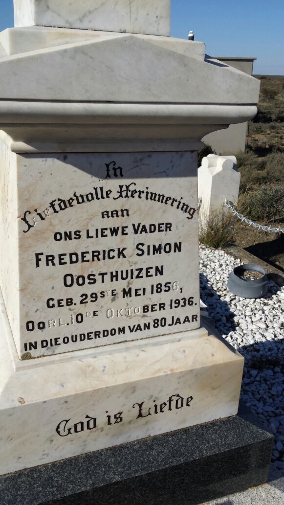
Frederik Simon Oosthuizen (29 May 1856–10 October 1936)
Zeekoegat church, In Liefdevolle Herinnering aan ONS LIEWE VADER FREDERICK SIMON OOSTHUIZEN, GEB. 29ste MEI 1856, OORL. 10de OKTOBER 1936, IN DIE OUDERDOM VAN 80 JAAR. On the base below: GOD IS LIEFDE.
-
1936
burial
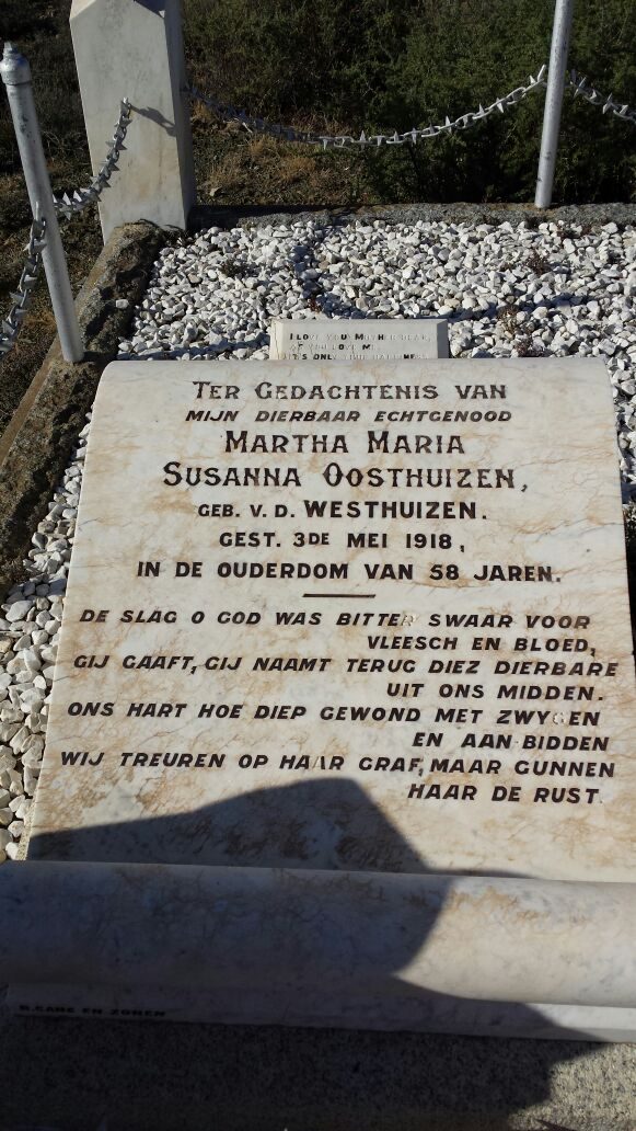
Martha Maria Susanna Oosthuizen (1859–3 May 1918)
Zeekoegat church, Ter Gedachtenis van mijn dierbaar echtgenood MARTHA MARIA SUSANNA OOSTHUIZEN, geb. v.d. WESTHUIZEN, GEST. 3de MEI 1918, IN DE OUDERDOM VAN 58 JAREN. Then: 'De slag o God was bitter swaar voor vleesch en bloed, Gij gaaft, Gij naamt terug diez dierbare uit ons midden. Ons hart hoe diep gewond met zwygen en aan bidden, wij treuren op haar graf, maar gunnen haar de rust.' A maker's mark is cut on the kerb below and is not legible in this photograph.
-
1936
burial
Hendrik Jacobus Oosthuizen (infant, 1883-1884) (19 October 1883–8 December 1884)
Zeekoegat church
- 21 September 1948 boundary change consolidated into: becomes Leeukraal No. 24 (consolidated)
- 2003 boundary change consolidation: becomes Farm 222
-
the 2020s
ownership
1 party/parties held back by the publishing rule
owner · confidence medium
- 2022 document local history
On the 1915 divisional map
As the Surveyor-General printed this farm in 1915: the registered holder, the date the title was issued and its quitrent reference, copied off the sheet as written. The whole map, farm by farm
| Farm, as printed | Holder | Title | Quitrent | Note |
|---|---|---|---|---|
| ZEEKOE GAT | J. L. Venter J. son | 15 April 1841 | B.W.Q. 6.6 · fol. 1031 | the parent grant; "Traka River" runs through |
| ZEEKOE GAT Amended Title | P. H. du Plessis | 20.1.1911 | · fol. 2563 |
Buried on this ground
- Zeekoegat church 3 graves recorded, 3 identified in this project · no coordinate yet
The burials also appear on this farm's timeline above, each at its own date.
Photographs
Also bordered by, as the modern cadastre draws it
Ground that touches this farm on the Surveyor-General's current polygons and that none of the diagrams held here names. Derived from the geometry, not read off a document.
- N Leeukraal No. 24 (consolidated)
- N Antjiesfontein (Leeukraal No. 24 Ptn 1)
- N Trakas Kuilen No. 15
- NE Wit Poortje No. 16
- E Klipgat No. 114
- E Zoutwater (Klipgat No. 114 Ptn 1)
- E Bontwater (Klipgat No. 114 Ptn 8)
- S Modderdrift No. 106
- S Modderdrift No. 106 Ptn 1
- S Modderdrift No. 106 Ptn 4
- S Modderdrift No. 239
- W Farm 222
Documents
ZeekoegatCameo.pdf
Cadastre
Surveyor-General diagram index for this parcel
Research notes
Frederik Simon OosthuizenH built the church here 1906; modern owner Oosthuizen F.S.
[1 Aug 2026, SRC-068] Three separate times the outside world came to this farm for something it could not get elsewhere: GOLD in 1871 and again in 1891, FOSSILS through Roy Oosthuizen's museum, and STARS, the European Southern Observatory built a working observatory here in 1958-61 (EVT-000238) before choosing Chile. Zeekoegat itself was also prospected in 1891 (EVT-000230). The cameo's own framing: "A tiny church is central to the story, and so are fossils, stars and even a ghost."
[3 Aug 2026, SRC-204] The 2003 consolidation LG 4295/2003 (DOC-0170) takes GEDEELTE 1 (ZEEKOEGAT) of this farm into DIE PLAAS NR 222 (PAR-000136), and in doing so names the portion's diagram - KAART 3557/1910, written over a struck-out 1457/1910 - and its grant, GRONDBRIEF NR P.A.Q. 6-6. WORTH SEEING TOGETHER: Spreeufontein's remainder is granted on P.A.Q. 6-1 and this on P.A.Q. 6-6 - the same grant volume, six entries apart. Two farms this project is built on were granted out of one book. [TO VERIFY against the grants, which are not held.]
[3 Aug 2026, SRC-227] A SWANEPOEL HELD PART OF IT FROM 1867. The 1912 diagram for Zout Water on Klipgat gives its western boundary as "Portion ZEEKOE GAT transferred to P.J. SWANEPOEL 30.7.1867". This model has no ownership span, portion or document recording that, and 9a keeps the Swanepoels in as a block. Which P.J. Swanepoel is not established. [TO VERIFY]
[SRC-327, 7 Aug 2026] A FARM CEMETERY IS RECORDED ON THIS GROUND BY eGGSA: 'Zeekoegate 22, Moeite Verniet', Cemetery ID 7517, at -33.031217, 22.466133. Photographs and captions at https://graveswcape.eggsa.org/PRINCE-ALBERT-Rural/0523002%20Moeite%20Verniet%20by%20Zeekoegat%20_Pieter%20Olckers/ - linked, not copied.
The research behind this page, kept separate from it: dated working notes, open questions, and what is not yet settled.
Open questions
-
Where did Frikkie's money come from
priority 2 · LEAD-0012
What built Frederik Simon OosthuizenH's (PER-000006) 81,000-morgen fortune around Zwartkraal?
What would settle it The 1936 estate inventory - it would list every farm with its purchase deed, date and value, i.e. the whole accumulation history in one document
What the record is missing
-
A tenure with no one in it
second order · B7 no-owner
OWN-000009 records a owner on Zeekoegate from 202X and names no party. Either the holder was never read off the document, or the publishing rule withheld them, the page cannot tell you which, and neither can this.
What would settle it There is no document on this span either; it wants one.
Found by breaks.py reading the model against itself, not written by hand,
each one is a shape of missing record, not a fault in the data.
The whole set is on the
questions page.