Wit Poortje No. 16
16 on the cadastre · on record 1872 · show on the map
- Farm number
- No. 16
- On the cadastre
- 16, whole farmregistered as WIT POORTJE
- District
- Prince Albert
- Extent, as the diagram states it
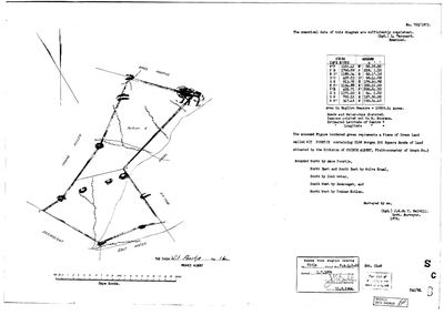
- 5168 morgen 300 square roods (1872)
- Modern surveyed area
- 4407.8 ha
The historic extent and the modern surveyed area are two separate measurements and are not presented here as confirming each other. The first is what a surveyor wrote on a diagram, usually in morgen. The second is what the modern cadastre draws.
Why this farm is here
A piece of a farm already in this model. 42 km from Klaarstroom.
- parcel Ground cut out of this farm: Wit Poortje No. 16 Ptn 1 (formerly Portion A)
- border Shares a boundary with Zeekoegate Zeekoegate
- border Shares a boundary with Trakas Kuilen No. 15 Trakas Kuilen No. 15
- document A document in the collection describes this ground DOC-0258
- …and 1 more, listed in full further down this page.
What the record holds, in order
-
1872
document
SG diagram 765/1873
P.A.Q.2-26
- 1872 document SG diagram verso 765/1873 (verso)
Ground cut out of this farm
Bordered by, as the diagram names them
- N Amos Poortje (1872)
- NE/SE Wolve Kraal (1872)
- S Zout Water (1872)
- SW Zeekoegat
- NW Trakas Kuilen
On the 1915 divisional map
As the Surveyor-General printed this farm in 1915: the registered holder, the date the title was issued and its quitrent reference, copied off the sheet as written. The whole map, farm by farm
| Farm, as printed | Holder | Title | Quitrent | Note |
|---|---|---|---|---|
| WIT POORTJE | J. M. C. Horn & another | 1 July 1879 | P.A.Q. 2.26 · fol. [?1464] | full label here; see a1c4 |
Also bordered by, as the modern cadastre draws it
Ground that touches this farm on the Surveyor-General's current polygons and that none of the diagrams held here names. Derived from the geometry, not read off a document.
- NE Wit Poortje No. 16 Ptn 1 (formerly Portion A)
- E Wolwekraal No. 17
- SE Klipgat No. 114
- S Zoutwater (Klipgat No. 114 Ptn 1)
- S Bontwater (Klipgat No. 114 Ptn 8)
- SW Antjiesfontein (Leeukraal No. 24 Ptn 1)
- W Leeukraal No. 24 (consolidated)
Documents
 Surveyor-General diagram, 765/1873, 1872
10FKU101 16 0.jpg
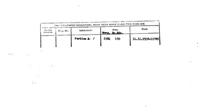 Diagram verso, 765/1873 (verso), 1872
10FKU801 16 0.jpg
Cadastre
Surveyor-General diagram index for this parcel
Research notes
[9 Aug 2026, SRC-342] A FARM THIS MODEL DID NOT HOLD, added from its own diagram. SG 765/1873: "The annexed Figure bordered green represents a Piece of CROWN LAND called WIT POORTJE containing 5168 Morgen 300 Square Roods of Land situated in the Division of PRINCE ALBERT, Field-cornetcy of GOUPH No.3", surveyed 1872 by J.W. du T. MELVILL, Government Surveyor, examined by L. MARQUARD. Bounded North by AMOS POORTJE, North East and South East by WOLVE KRAAL, South by ZOUT WATER, South West by ZEEKOEGAT, and North West by TRAKAS KUILEN. Titled P.A.Q.2-26 on 1 JULY 1879.
THE SHEET CHECKS ITSELF IN TWO UNITS. Beside the morgen it states "Area in English Measure = 10939.34 Acres". 5,168.5 morgen is 4,427.0 ha is 10,939.32 acres, which is 0.0002% from the stated figure. Two units written by one hand and they agree.
IT WAS ALREADY NAMED HERE FROM THE OTHER SIDE. PAR-000179's neighbour ring lists "the Remainder of Wit Poortje", and this farm's own boundary list names ZEEKOEGAT (PAR-000013, where Frederik Simon OosthuizenM built the church) and TRAKAS KUILEN (PAR-000180/181, processed 8 Aug). The ring closes from both directions.
"Beacons pointed out to M. BOOYENS" - a man on the ground in 1872, named on the sheet and in no other record here.
The form asks for the Estimated Latitude and Longitude of Centre and BOTH ARE BLANK.
NOTE THE TITLE DATE: P.A.Q.2-26 of 1 July 1879. PAR-000099 carries title P.A.2-21 of the SAME DAY, an adjacent folio in the same volume. Whether 1 July 1879 is another grant run like 15 April 1841 is worth asking. [TO VERIFY]
[9 Aug 2026] NOW ON THE MAP, and the cadastre is the third unit to agree. match_cadastre pinned this row to W052C061000000000016000000 at 4,407.8 ha, against the 1873 sheet's 5,168 morgen 300 roods = 4,427.0 ha: 0.43% apart. So the sheet's morgen, the sheet's own acre figure and the modern polygon all describe the same ground.
The research behind this page, kept separate from it: dated working notes, open questions, and what is not yet settled.
What the record is missing
-
“Wolve Kraal” is named as a neighbour 2 times and we hold no parcel for it
third order · B3 unheld-farm
2 separate surveys in this model put Wolve Kraal on the boundary of ground we do hold (PAR-000153, PAR-000182). It has no parcel of its own here, so nothing is known about who held it or when, while it borders farms at the centre of the project.
What would settle it The Surveyor-General's farm index for the registration division will give it a farm number and a diagram; the cadastre pull in `fetch_cadastre.py` then places it on the map.
-
“Zout Water” is named as a neighbour 2 times and we hold no parcel for it
third order · B3 unheld-farm
2 separate surveys in this model put Zout Water on the boundary of ground we do hold (PAR-000176, PAR-000182). It has no parcel of its own here, so nothing is known about who held it or when, while it borders farms at the centre of the project.
What would settle it The Surveyor-General's farm index for the registration division will give it a farm number and a diagram; the cadastre pull in `fetch_cadastre.py` then places it on the map.
-
Nobody is on record as ever having held this
third order · B8 never-held
Wit Poortje No. 16 is in the model and drawn on the map, and carries no ownership record of any kind, not a grant, not a transfer, not an occupation.
What would settle it The Surveyor-General's diagram for the farm number names the grantee and the date; the deed reference on it opens the transfer chain.
Found by breaks.py reading the model against itself, not written by hand,
each one is a shape of missing record, not a fault in the data.
The whole set is on the
questions page.