Part of Middelwater
Vaste Water (Middelwater No. 169 Ptn 5)
· on record 1884–1923 · show on the map
The farm's own history, the grant, the original survey, sits on that page.
- Farm number
- No. 169
- Portion
- 5
- District
- Prince Albert
- Extent, as the diagram states it
- 9 morgen 520 sq roods
- Modern surveyed area
- 9.1 ha
The historic extent and the modern surveyed area are two separate measurements and are not presented here as confirming each other. The first is what a surveyor wrote on a diagram, usually in morgen. The second is what the modern cadastre draws.
Why this farm is here
J.D.J. Oosthuyson / O.A. Oosthuysen (reading uncertain) held it. 4 km from Klaarstroom.
J.D.J. Oosthuyson / O.A. Oosthuysen (reading uncertain) is on record on this ground directly. No trace needed.
- story A written history is set on this ground Middelwater's story since 1777
- story A written history names this ground Who are the two people from the loft at Klueplaas, on old Middelwater, about 1875?
- parcel Cut out of Middelwater
- document A document in the collection describes this ground DOC-0076
- …and 2 more, listed in full further down this page.
Stories
- about this farm
Middelwater's story since 1777
From a loan farm on the Zwartberg to eight cadastral parcels: the full documented history of Middelwater No. 169 - Stretch's 1833 survey for Okert Oosthuizen, the twelve-farm grant day of 1841, the 1883 resurvey and the 1884 quitrent to J.D.J. Oosthuysen 'and another', the portions cut off for a spring called Vaste Water and a place called Avondrust, and the 1990 power-line survey whose coordinates finally put the farm on a map.
- mentions this farm
Who are the two people from the loft at Klueplaas, on old Middelwater, about 1875?
Two framed portrait sketches out of a loft on Klueplaas, which is ex-Middelwater ground. No names on the backing. A strong circumstantial case that they are Ockert Almero Oosthuizen and Aletta Hitge, and no evidence at all. The images are NOT published: permission has not been asked.
Before this ground was cut out
This is the history of Middelwater, the farm this ground was part of until 1923. It is shown here because this ground was that farm, and separately from what follows because before the cut the record says the farm's name and not which part of it. Not everything below necessarily happened on this piece.
- 1777/1860 boundary subdivision: from De Claar Stroom (the 1777 loan farm)
- 1777/1860 boundary subdivision: becomes Middelwater
- 1777/1860 boundary same_as: becomes De Claar Stroom (Klaarstroom No. 178)
- 1777 event De Claar Stroom loan farm granted parent farm of Middelwater and Klaarstroom This is PAR-000097, Klaarstroom No. 178. The loan farm itself is PAR-000004.
- 1821~ to 188X ownership Cornelis Andries Oosthuizen (1792-06-14–1860) occupation · confidence medium
- 1821~ residence Cornelis Andries Oosthuizen (1792-06-14–1860) farming
- 1822 ownership Jan Louis Venter (1754–1824), Johanna Jacomina Smit (1760–1824) loan farm · occupation · confidence high
- 1822 residence Jan Louis Venter (1754–1824) tax roll
- 1833 boundary consolidation: becomes Drooge Kloof
- 1833-08 document SG diagram 349/1833 Bf.W.Q.5-7
- 1833 to 1841-04-15 ownership Ockert Almero Oosthuizen (1786-04-24–1859-02-26) loan farm · occupation · confidence high
- 1836-11-27 residence Ockert Almero Oosthuizen (1836-11-27–1922-01-02) birth/farming
- 1836 residence Susanna Catharina Oosthuizen (b.1819) (1819-05-31–1856-09-24) farming
- 1841-04-15 ownership owner not named in the record Perpetual Quitrent · grant · confidence medium
- 1850~ residence Cornelis Andries Oosthuizen (b.1828) (1828–1871-04-24) farming
- 1860-02-18 residence Johanna Machteld Petronella Strydom (1792-01-05–1860-02-18) farming · to 1860-02-18
- 1865 event The 1865 drought: watering the Middelwater orange grove from vats So dry that Jan Adriaan Oosthuizen, then living on Middelwater (PAR-000001), watered the orange grove before the house with wagon and vats so the trees would not die; the only water left stood in the heights toward Kouwveldt at the steep drift. His grandson's diary carries it, from his son's telling - the only picture of daily life on Middelwater in the 1860s this record holds.
- 1865~ residence Johannes Adriaan Oosthuizen (1816-11-20–1882-08-11) memoir
- 1883 boundary subdivision: becomes Klein Vlei (Middelwater portion)
- 1883-10 document SG diagram 1364/1883 P.A.Q.3-3
- 1883 document SG diagram verso 1364/1883 (verso)
- 1884-03-24 ownership Jacobus Daniel Johannes Oosthuizen (1823-09-02–1903-06-11), Oosthuysen co-owner (unidentified) quitrent · grant · confidence high
- 1923 boundary subdivision: becomes Vaste Water (Middelwater No. 169 Ptn 5)
- 19XX boundary subdivision: becomes Rietfontein
- undated boundary remainder: becomes Moreson (Middelwater No. 169 Remainder)
- undated boundary subdivision: becomes Middelwater No. 169 Ptn 1
- undated boundary subdivision: becomes Middelwater No. 169 Ptn 2
- undated boundary subdivision: becomes Middelwater No. 169 Ptn 3
- undated boundary subdivision: becomes Ebeneser (Middelwater No. 169 Ptn 4)
- undated boundary subdivision: becomes Middelwater No. 169 Ptn 7
- undated boundary subdivision: becomes Remainder (Middelwater No. 169 Ptn 2)
What the record holds, in order
-
24 March 1884
ownership
J.D.J. Oosthuyson / O.A. Oosthuysen (reading uncertain), J.N. Botha
amended-title · confidence medium
- 1923 boundary change subdivision: from Middelwater
-
February 1923
document
SG diagram A.332/1923
3007
- 6 February 1923 document surveyor report A.332/1923 (report)
-
26 April 1923
ownership
Susanna Maria Klue
transfer · confidence medium
Also bordered by, as the modern cadastre draws it
Ground that touches this farm on the Surveyor-General's current polygons and that none of the diagrams held here names. Derived from the geometry, not read off a document.
- N Middelwater No. 169 Ptn 2
- NE Ebeneser (Middelwater No. 169 Ptn 4)
- S Moreson (Middelwater No. 169 Remainder)
- W Avondrust (Middelwater No. 169 Ptn 6)
- NW Remainder (Middelwater No. 169 Ptn 2)
Documents
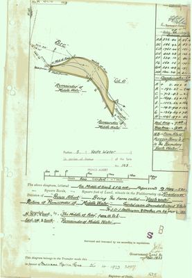 Surveyor-General diagram, A.332/1923, February 1923
10777883.PDF
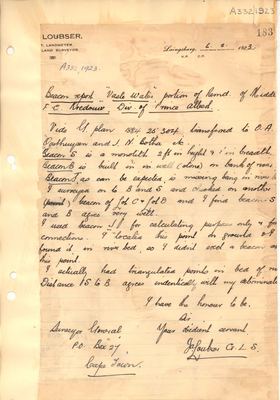 Surveyor's report, A.332/1923 (report), 6 February 1923
10777885.PDF
Cadastre
Surveyor-General diagram index for this parcel
Surveyor-General diagram index for the whole farm, where the original survey of this ground sits.
Research notes
Cut from Middelwater; SG A.332/1923, deed 3007. Portion 5 of farm 169 - three documents agree (DOC-0076 face "Portion 5", DOC-0039 verso "169/5", DOC-0040 "Gedeelte 5"). "Vaste Water" is the spring marked on the 1883 diagram. Extent 9 morgen 520 sq roods (DOC-0076 face and DOC-0039 verso agree). [29 Jul 2026] Own diagram and beacon report: DOC-0076/DOC-0077. [TO VERIFY] Transfer date conflict is real and unresolved: 26.4.1923 (DOC-0076's own handwritten transfer line) vs 26/5/1923 (DOC-0039's typed verso), same deed 3007 - deed 3007/1923 itself would settle it. Grantee name also differs across DOC-0076/DOC-0077 - see OWN-000057/OWN-000058. [30 Jul 2026] Matched to cadastre 5/169 on the portion number, which three documents give (DOC-0076 face, DOC-0039 verso, DOC-0040). [5 Aug 2026] THE AREA DISAGREEMENT IS RESOLVED. This note read: the diagram's 9 morgen 520 sq roods is 8.45 ha against a cadastre parcel of 10.9 ha, 29% larger. 10.9 ha is GEOM_AREA/10 000, the field found on 5 Aug 2026 to be inflated by 1/cos(lat) on 429 records; the true polygon is 9.1 ha (Shape_Area), which sg_area_ha now carries. The diagram's figure runs 7.7% low against that - a large percentage on a nine-hectare parcel, where a single misread square-rood digit moves it further than any survey error would. Identity was never in doubt and still is not. [30 Jul 2026] INDEPENDENTLY CONFIRMED, not on the portion number alone: the Lo23 survey coordinates on DOC-0040, converted from Cape Datum, place servitude beacons A and C, which sit 0.73 km NE of it in portion 4 exactly as the diagram draws them against this polygon - and that diagram letters this same ground "Gedeelte 5 (Vaste Water)". Method and the full beacon test in SRC-053.
[13 Aug 2026] Renamed to the one form this model uses for every portion - the portion's own name, then the parent farm, its number and the portion in brackets - so that a name is legible in a list, a search result and a map popup without the reader having to know which farm number is which. It read "Vaste Water (Middelwater portion)" before. Nothing about the ground changed.
The research behind this page, kept separate from it: dated working notes, open questions, and what is not yet settled.
Open questions
-
Is Arthur Kleu the painter one of the Kleus of Klueplaas? And is Kleu the same surname as Klue?
priority 3 · LEAD-0125
Frans holds a painting of MEIRINGSPOORT by ARTHUR LIONEL KLEU (1915-2008), a shopkeeper, inherited from his grandfather. Middelwater carries the werf name KLUEPLAAS. Are they one family, and are Kleu and Klue one surname?
What would settle it A common ancestor, or a Kleu/Klue baptism at Prince Albert or Klaarstroom in the nineteenth century that ties either line to the district.
What the record is missing
-
The record stops in 1923 and never resumes
second order · B2 trail-ends
Vaste Water (Middelwater No. 169 Ptn 5) was worked as far as 1923-04-26, with Susanna Maria KlueH the last owner on record. 103 years follow with nothing. Who held it after that, and is it still one farm?
What would settle it The current title deed traced backwards, each transfer names the one before it, or the Surveyor-General's subdivision diagrams, which are what usually explain a farm going quiet.
-
39 years, and the ground changes hands to nobody we can follow
second order · B1 succession
On Vaste Water (Middelwater No. 169 Ptn 5), J.D.J. Oosthuyson / O.A. OosthuysenH (reading uncertain) and J.N. BothaH is the last owner recorded from 1884-03-24, and the next entry is Susanna Maria KlueH from 1923-04-26, 39 years later, with no person in common. DOC-0076 records the later arrival but not the 39 years before it.
What would settle it The Deeds Office transfer register for this farm between 1884 and 1923. A transfer names its predecessor in title, so one deed closes the whole gap.
Found by breaks.py reading the model against itself, not written by hand,
each one is a shape of missing record, not a fault in the data.
The whole set is on the
questions page.