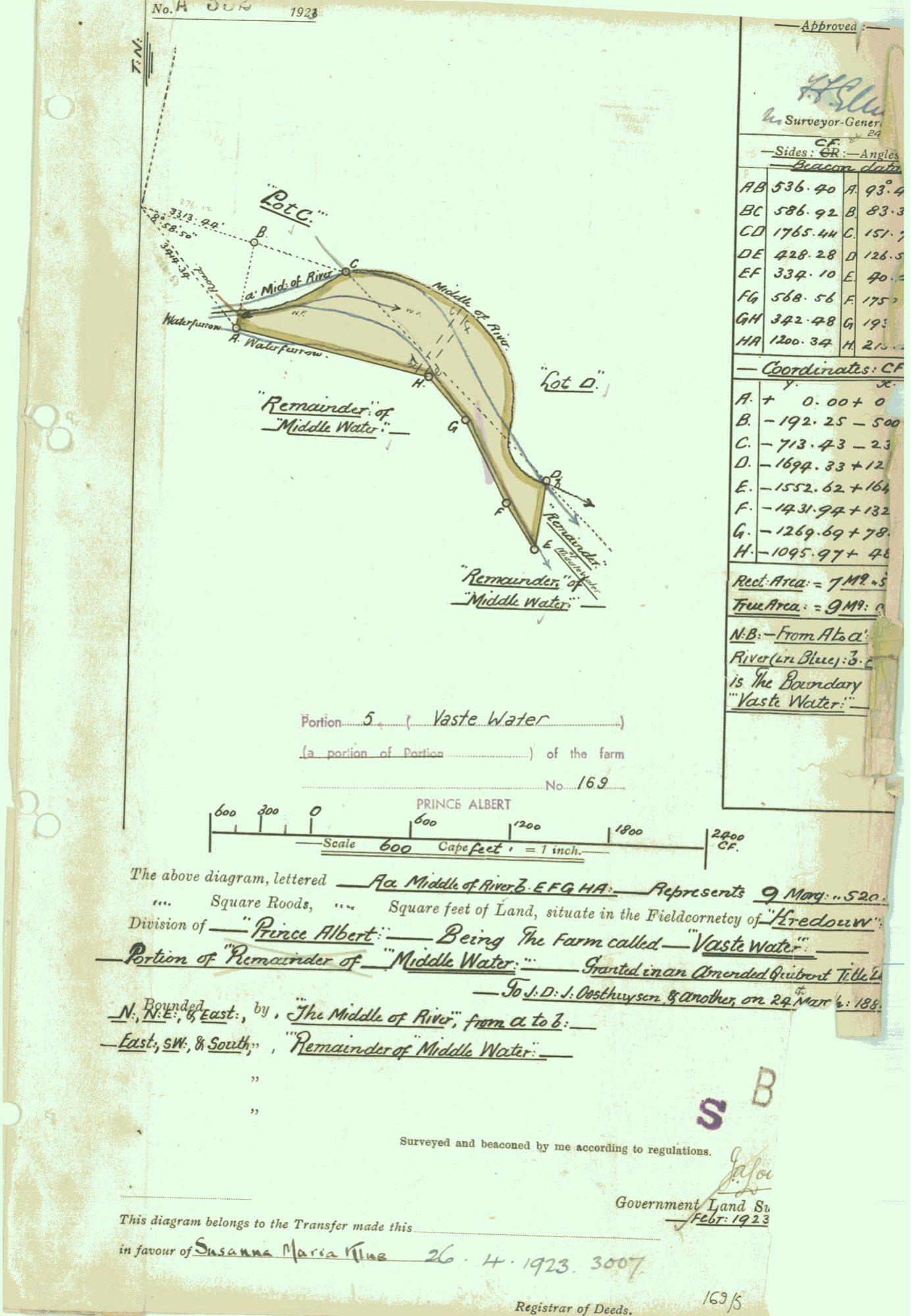
Surveyor-General diagram, A.332/1923, February 1923
Surveyor-General diagram, February 1923
10777883.PDF.The record
- Type
- Surveyor-General diagram
- Diagram number
- A.332/1923
- Surveyed
- February 1923
- Titled
- 26 April 1923
- Deed
- 3007
- Archive filename
- 10777883.PDF
Citation
- Title
- Middelwater / Vaste Water diagram, 1923
- Repository
- Surveyor-General
- Reference
- SG Dgm A.332/1923
- Type
- SG diagram
The ground it is about
Vaste Water (Middelwater No. 169 Ptn 5)
Research notes
"Portion 5 (Vaste Water), a portion of Portion [Remainder of Middle Water] of the farm No.169" (Middelwater, PAR-000001). Represents "9 Morg[en] ... Square feet" of land [extent figure partly illegible on this scan], Fieldcornetcy of Kredouw, Division of Prince Albert, being the farm called "Vaste Water", a portion of the "Remainder of Middle Water". "Granted in an Amended Quitrent Title ... To J.D.J. Oosthuyson (PER-000324) & another, on 24 Mar[ch] 188X [year's final digit unclear]." Bounded N, NE & East by the Middle of the River from a to b; East, SW & South by Remainder of Middle Water. Neighbouring parcels shown: Lot C, Lot D, Remainder of Middle Water. Surveyed and beaconed February 1923 [surveyor's own signature illegible on this scan - see the companion beacon report, DOC-0077, signed J. Loubser, for the same job]. "This diagram belongs to the Transfer made this [date] in favour of Susanna Maria KlueM [surname legible on the colour scan, 29 Jul 2026; PER-000326], 26.4.1923, deed 3007." [TO VERIFY] parcels.csv's own pre-existing note for PAR-000040 gives this same deed (3007) a transfer date of 26 May 1923, one month later than this diagram's own 26 April 1923 - not reconciled, both dates kept, see OWN-000058. CLOSES ONE OF MIDDELWATER'S THREE PORTIONS THAT PREVIOUSLY HAD NO DIAGRAM AT ALL.
The research behind this page, kept separate from it: dated working notes, open questions, and what is not yet settled.