Moerasfontein No. 27 (Uniondale)
· on record 1880 · show on the map
- Farm number
- No. 27
- Also recorded as
- Moeras Fonteyn; Moerasfontein
- Modern surveyed area
- 2942.1 ha
Why this farm is here
Ground a written history is set on. 80 km from Klaarstroom.
- story A written history names this ground Before the Koup: the Cango and the Olifants, 1760-1824
- parcel Related to De Modder Fonteyn (aan d'Olifants rivier)
- document A document in the collection describes this ground DOC-0344
- burial A burial ground stands on this farm Moerasfontein (Uniondale district)
- …and 2 more, listed in full further down this page.
Stories
- mentions this farm
Before the Koup: the Cango and the Olifants, 1760-1824
A prelude in timeline form. From Louis van Wyk's loan place Vergelegen in the Cango in 1760, through the van Tonder and van Wyk kin of Susanna Catharina van Tonder, to Ockert Oosthuizen's death on de Modder Fonteyn in 1809, the farm's passing out of the family, and his eldest son on Vrolykheid in the Koup by 1822. Each entry says why it belongs on the road.
What the record holds, in order
-
1880
document
SG diagram B1092/1880
Un.Q.1-5
- undated boundary change same_as: from De Modder Fonteyn (aan d'Olifants rivier)
Buried on this ground
- Moerasfontein (Uniondale district) 0 graves recorded
The burials also appear on this farm's timeline above, each at its own date.
Also bordered by, as the modern cadastre draws it
Ground that touches this farm on the Surveyor-General's current polygons and that none of the diagrams held here names. Derived from the geometry, not read off a document.
- N Roodeklip No. 26 (Uniondale)
- E Misgund No. 25 (Uniondale)
- SE Mordenaarsberg No. 81 (Uniondale)
- SE Farm No. 478 (Uniondale)
- SW Bakenskop No. 30 (Uniondale)
- SW Farm No. 468 (Uniondale)
- NW Georgida Laagte No. 36 (Uniondale)
Documents
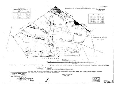 Surveyor-General diagram, B1092/1880, 1880
10230370.jpg
Cadastre
Surveyor-General diagram index for this parcel
Research notes
The VELDKORNETSKAP OLIPHANTS RIVIER of the George district, named and listed on George opgaafrol J 91 (SRC-525). Added after that page identified the country the family's Olifants farms lay in. PREQUEL GROUND under 9a - the Oosthuizen road into the Koup - and NEVER `core`, so it must not move the map's opening bounds. *** FRANS RAISED THIS ONE AS A CANDIDATE FOR DE MODDER FONTEYN: 'they were listed next to moeras fontein... sounds a lot like modder fontein'. *** Moeras is marsh and modder is mud, and both name a boggy spring, so a clerk or a family could carry either. THE DISTANCE ARGUES AGAINST IT AND IS RECORDED HERE BECAUSE OF THAT: the 1805 roll puts Modderfonteyn at 43 UUREN from the Swellendam drostdy, and on this project's own calibration (SRC-497) that is about 227 km. Moerasfontein measures 277 km, or 52 uuren - nine too far. The farms that sit ON 43 are at the WESTERN end of this cornetcy: Diepe Kloof 41.5, Schoongezigt 42.7, Roodeheuvel 42.8, Buffels Klip 44.1. So the name fits and the distance does not. [TO VERIFY] - and note the calibration is straight-line, taken on easier ground west of here, so it may overstate the km per uur across the Gouritz and the passes, which would pull the answer further west still rather than east.
[16 Sep 2026] THE NAME NOW HAS HOLDERS AND IT MATCHES. The George rolls write one farm as 'Modder Fontyn' and 'Moeras Fontyn' interchangeably: Salomon Terblans x Hester Mare with 8500 vines is 'Moeras Fontyn' in 1822 and 'Modder Fontyn' in 1823, and Daniel Jacobus ErasmusM with 6000 vines is 'Moeras Fontyn' in 1825 and 'Modder Fontyn' in 1826, quit rent, on the row after Wanhoop. So the title name Moerasfontein is very likely the old Modder Fontyn, the farm of PAR-000065. The distance objection above stands on the 1805 Swellendam figure and is weakened by these rolls' own inconsistency (Wanhoop is 43 uren on one 1823 leaf and 48 on another). Full register on PAR-000065 and data/opgaaf_land.csv. [TO VERIFY] by the first quitrent grant.
[16 Sep 2026] ITS DIAGRAM READ (DOC-0344, B1092/1880): 4317 morgen 500 sq roods, Field-Cornetcy of Antoniesberg, a RESURVEY under Act VII of 1865 of land already held on quitrent, title Un.Q.1-5 of 21 January 1881; north Roode Klip, south and west Crown land, east 'Elandspoort & MISGUND as claimed'; the Olifants River across its northern corner, houses and a dam on a stream in the middle. So Moerasfontein was a quitrent farm before 1879 and Misgund is its eastern neighbour, both of which fit the Modder/Moeras Fontyn of the George rolls. The first quitrent grant diagram, presumably to D.J. Erasmus in the 1820s, is still to be found.
[16 Sep 2026] 'LOANPLACE MOERASFONTYN' IS WRITTEN ON A SURVEYOR'S SHEET. The 1832 diagram of Roodeklip No. 26 (DOC-0359, SRC-649) is 'applied for by Salomon Terblans Steph:zn', extends 'SW to Moerasfontyn', and letters the adjoining ground 'Loanplace Moerasfontyn'. Salomon Terblans Steph.z is the man on 'Modder fontein' in the George roll of 1818 and on 'Moeras/Modder Fontyn' to 1823 (data/opgaaf_land.csv). So the farm was still a LOAN PLACE in 1832, called Moerasfontyn, and lay south-west of Roodeklip, which is where Moerasfontein No. 27 lies. Misgund's 1832 sheet (DOC-0361) has government ground applied for by S. Terblans to its west and Wanhoop to its east. The six neighbours are now parcels PAR-000327 to PAR-000332.
[16 Sep 2026] THE ERASMUS WHO HELD IT FROM 1824 IS VERY LIKELY DANIEL JACOBUS ERASMUS (b. 30 June 1785, d. 5 October 1861), 'Oupa Swartkoppies', married to Cornelia Jacoba Susanna Kruger - the rolls write his wife 'Cornelia Sus. Kruger' (1824) and 'C.S. Krieger' (1825). A family blog citing the Colonial Office papers (SRC-650) has him farming WANHOOP 'very near Rooiklip' before he trekked north to Swartkop (Centurion), and has Salomon Terblans selling the neighbouring Roode Klip to his brother Stephanus Erasmus. So the farm passed Oosthuizen (to 1816) - Terblans (1818-1823) - Erasmus (1824-), and the Erasmuses left the colony in the Great Trek period, which would explain why a loan place called Moerasfontyn was still untitled in 1832. [TO VERIFY] the identity by a document naming Daniel Jacobus ErasmusM with the place.
[22 Sep 2026, SRC-663] An 1850 map of the George veldkornetskappe (HSRC typescript p. 152, from J.G. le Roux's eGGSA series) draws MOERASFONTEIN on the Olifantsrivier in the ANTONIESBERG veldkornetskap, beside Rooi Klip, Misgund, Wanhoop, Dwaas, Perdefontein, Oupos and Naugasfontein - this farm's own neighbours. NAMESAKE WARNING: the same district had a second Moerasfontein in Die Vleie near the coast (the Barnards', 1850). An Erasmus is among Antoniesberg's owners in 1850.
[22 Sep 2026, FRANS] IDENTIFIED WITH DE MODDER FONTEYN (PAR-000065) by a same_as link, PLK-000144, which carries the evidence. The family's 1809 estate farm is therefore drawn here, red on the map as ground a direct ancestor held. The first quitrent grant is still to be found [TO VERIFY].
[22 Sep 2026, SRC-434] SPARRMAN'S MAP OF 1775-76 DRAWS A 'MORASS R.' running into the Oliphants Rivier on this stretch, between the Attaquas Kloof and the Kammanassie - the Moeras water this farm is named for, named on a map a generation before the farm's first title and independent of the rolls and the diagrams.
The research behind this page, kept separate from it: dated working notes, open questions, and what is not yet settled.
Open questions
-
Read KAB CO 4008 p.32 and CO 4044 p.64 - the Roode Klip memorials that name Salomon Terblans, the Erasmus brothers and 'Mosasfontein'
priority 1 · LEAD-0352
A 2012 family blog (SRC-650) quotes Colonial Office papers of 1841-1849 on the loan place Roode Klip, 'contiguous to Mosasfontein, Orgida and Misgunst', held by Salomon Terblans from 30 June 1832 with 'Oudebos', sold to Stephanus Erasmus. Do the originals also say who held Moerasfontein, and when it was granted?
What would settle it A document naming Moerasfontein with its holder in the 1820s-1840s, or its first quitrent title.
-
The Veldkornetskap Oliphants Rivier farms - is this family tied to any of them beyond its own place?
priority 2 · LEAD-0270
Eleven Uniondale farms from the George rolls are now on the map - Nietgenaamd 9, Gorgida 14, Misgund 25, Moerasfontein 27, Keurfontein 45, Wilge River 46, Schoongezigt 52, Roodeheuvel 55, Diepe Kloof 56, Buffels Klip 63, Wilgehoute Rivier 69. *** NOT ONE OF THEM CARRIES A SINGLE OWNERSHIP ROW OR A NAMED HOLDER IN THIS MODEL. *** They are neighbours read off a roll, pinned to a cadastre. Is there any actual family tie to them, or only to Wanhoop and Modderfonteyn?
What would settle it A named holder on one of those eleven farms who is already a person here, or marries one.
-
Antoniesberg farms of 1850 not yet on the map: Dwaas, Wanhoop, Naugasfontein, Klein Grobbe
priority 3 · LEAD-0361
Which modern farm numbers are the 1850 farms around Moerasfontein that J.G. le Roux names and the HSRC map on p. 152 draws, and that the cadastre does not hold under those names? DWAAS is in the CSG index as Dwaas No. 428 (Uniondale), with Dwaasberg No. 414 beside it, but neither is in the provincial cadastre pull. WANHOOP, NAUGASFONTEIN (Frederik Salomon Terblanche, b. 1807, in 1850) and KLEIN GROBBE (Hendrik Johannes Nel) return nothing from the CSG index under any spelling tried (Wan Hoop, Naugas, Noagas, Nougasfontein, Naauwgas, Grobbe, Grobbelaars).
What would settle it A diagram or quitrent title that gives the 1850 name against a farm number.
What the record is missing
-
Nobody is on record as ever having held this
third order · B8 never-held
Moerasfontein No. 27 (Uniondale) is in the model and drawn on the map, and carries no ownership record of any kind, not a grant, not a transfer, not an occupation.
What would settle it The Surveyor-General's diagram for the farm number names the grantee and the date; the deed reference on it opens the transfer chain.
Found by breaks.py reading the model against itself, not written by hand,
each one is a shape of missing record, not a fault in the data.
The whole set is on the
questions page.