Surveyor-General diagram, B1092/1880, 1880
Surveyor-General diagram, 1880
10230370.jpg.The record
- Type
- Surveyor-General diagram
- Diagram number
- B1092/1880
- Surveyed
- 1880
- Titled
- 21 January 1881
- Deed
- Un.Q.1-5
- Surveyor
- J.A. Thwaits
- Examiner
- Max Jurisch
- Archive filename
- 10230370.jpg
Citation
- Title
- Moerasfontein No. 27 diagram B1092/1880 (resurvey under Act VII of 1865; title Un.Q.1-5, 21 January 1881)
- Repository
- Surveyor-General
- Reference
- SG Dgm B1092/1880; copied from diagram relating to title Un.Q.1-5 dated 21.1.1881
- Type
- SG diagram
- Retrieved
- 2026-08-23
The ground it is about
Moerasfontein No. 27 (Uniondale)
Research notes
'Field-Cornetcy of Antoniesberg' - a ward name not otherwise held here, and forty-eight years later than the 1832 sheets on neighbouring ground. Uniondale was cut from George in 1856, so the wards were redrawn between the two. PLC-000090. The diagram number was not legible on the first copy held; recorded then as unread rather than guessed, and read on 16 Sep 2026 as B1092/1880.
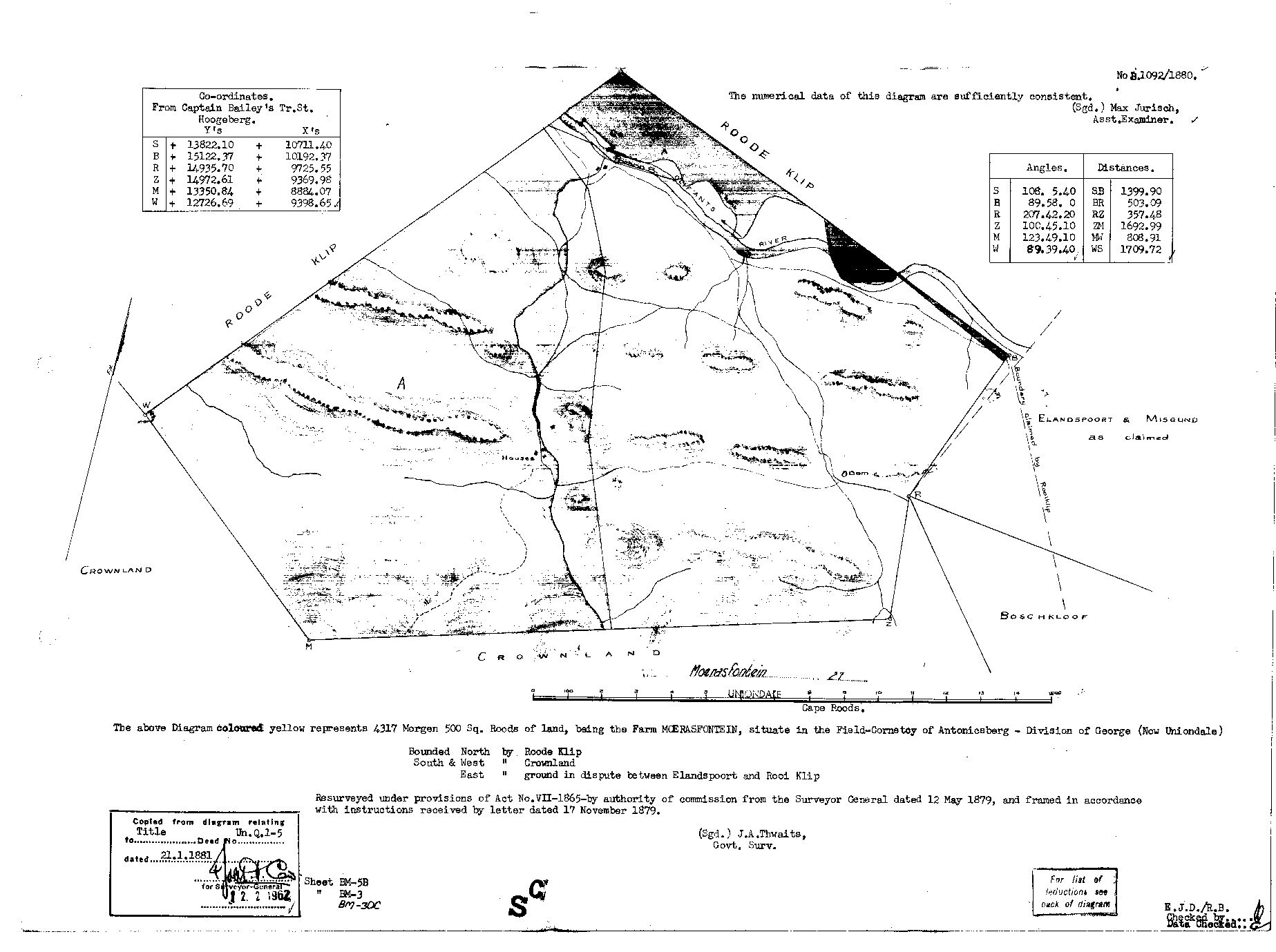
[16 Sep 2026] READ IN FULL off a clearer copy supplied by Frans. Diagram No. B.1092/1880. 'The above Diagram coloured yellow represents 4317 Morgen 500 Sq. Roods of land, being the Farm MOERASFONTEIN, situate in the Field-Cornetcy of Antoniesberg - Division of George (Now Uniondale). Bounded North by Roode Klip, South & West by Crownland, East by ground in dispute between Elandspoort and Rooi Klip.' 'Resurveyed under provisions of Act No. VII-1865 by authority of commission from the Surveyor General dated 12 May 1879, and framed in accordance with instructions received by letter dated 17 November 1879. (Sgd.) J.A. Thwaits, Govt. Surv.' Examined: '(Sgd.) Max Jurisch, Asst. Examiner.' Copied from diagram relating to Title Un.Q.1-5 dated 21.1.1881. Co-ordinates from Captain Bailey's Tr. St. Hoogeberg. ON THE FACE: the Olifants River crosses the northern corner along the Roode Klip boundary; a stream runs south through the farm to 'Houses' and a 'Dam' in its middle; east of beacon B the ground is marked 'Elandspoort & Misgund as claimed' with 'Boundary claimed by Rooiklip', and Boschkloof lies to the south-east. WHAT IT MEANS FOR PAR-000065: Act VII of 1865 provided for resurveying QUITRENT land already granted, so this is a RESURVEY, not a first grant - Moerasfontein was already held on quitrent before 1879, which fits Daniel Jacobus ErasmusM's quitrent place 'Moeras/Modder Fontyn' of 1825-1826 (SRC-642, SRC-648). The earlier grant diagram is what names the first grantee and is still to be found. And MISGUND IS ITS EASTERN NEIGHBOUR ON THE SHEET ITSELF, the farm held with Wanhoop in 1813 and listed beside it c.1813 (SRC-563, SRC-525).
The research behind this page, kept separate from it: dated working notes, open questions, and what is not yet settled.