Part of Rhemhoogte No. 125
Kareemoerhoek (Rhemhoogte No. 125 Ptn 4)
· on record 1884–1937 · show on the map
The farm's own history, the grant, the original survey, sits on that page.
- Farm number
- No. 125
- Portion
- 4
- Also recorded as
- KareemoerhoekDIAGRAM 4241/1937, deed 13528/1937KareemoershoekSRC-436, 2023 valuation roll
- District
- Prince Albert
- Extent, as the diagram states it
- 1654.0080 morgen
- Modern surveyed area
- 1561.1 ha
The historic extent and the modern surveyed area are two separate measurements and are not presented here as confirming each other. The first is what a surveyor wrote on a diagram, usually in morgen. The second is what the modern cadastre draws.
Why this farm is here
John Peter Oosthuizen held it. 14 km from Klaarstroom.
John Peter Oosthuizen is on record on this ground directly. No trace needed.
- story A written history is set on this ground Frikkie Oosthuizen's land moves on: Anna Margaretha and her three farms, 1937
- story A written history names this ground Oom Frikkie's eighty-one thousand morgen, 1856-1937
- parcel Cut out of Rhemhoogte No. 125
- parcel Cut out of Groot Sleutelfontein (Rhemhoogte No. 125 Ptn 2)
- …and 2 more, listed in full further down this page.
Stories
- about this farm
Frikkie Oosthuizen's land moves on: Anna Margaretha and her three farms, 1937
On 20 December 1937 one transfer deed put three farms and 11,897 morgen into the name of Anna Margaretha Marincowitz, born Oosthuizen - Tokkie's mother, and one of only seven women in this model recorded holding ground in her own right. Her father had died fourteen months earlier and her brother took the neighbouring portion the same day.
- cites this farm
Oom Frikkie's eighty-one thousand morgen, 1856-1937
Frederik Simon 'Oom Frikkie' Oosthuizen died in 1936 holding, by one account, 81,000 morgen around Zwartkraal - about a quarter of all the ground on this map. This project holds not one deed in his name. What the money was probably in, what it was certainly not in, and the one document that would settle it.
Who stood on this ground, and how they were related
Everyone the record places here - by deed, by residence, or by burial - and the kinship between each pair of them. Two numbers are given and they are deliberately kept apart. Steps is how far apart two people are in the family graph, counting a marriage as one step. The common ancestor is the nearest one they share by blood, with the year they were born. A pair four steps apart through a couple born in the 1750s is a relationship; a pair ten steps apart through a progenitor born in the 1630s is background, because almost everybody descends from him. Read both.
- 1884 John Peter Oosthuizen held 1884-01-25
- 1937 Anna Margaretha Oosthuizen held 1937-12-20
| Steps | Between | Nearest common ancestor by blood |
|---|---|---|
| 3 | John Peter Oosthuizen · Anna Margaretha Oosthuizen | Jacobus Daniel Johannes Oosthuizen born 1823 (1+2 generations up) |
Drawn from the parentage and marriages this project holds, never from a shared surname. A pair with no common ancestor here may still be related through a link nobody has recorded yet.
Before this ground was cut out
This is the history of Rhemhoogte No. 125, the farm this ground was part of until 1937. It is shown here because this ground was that farm, and separately from what follows because before the cut the record says the farm's name and not which part of it. Not everything below necessarily happened on this piece.
- 1873 document SG diagram verso 861/1873 (verso)
- 1875 document SG diagram B.876/1875 P.A.Q.2-20
- 1879-07-01 ownership Abel Albertus Oosthuizen (1849-10-05–1918-06-22) Perpetual Quitrent · grant · confidence medium
- 1901-02-02 event The skirmish at Remhoogte, and the death of Johannes Kleu [SRC-010, Rose Willis Klaarstroom cameo. TERTIARY, TO VERIFY] The Boers caught the retreating Yeomanry at REMHOOGTE, a farmstead beside the old Prince Albert road, and shot the horses from under them. Lance-Corporal J. Boyd, wounded, sheltered at Wolwekloof; Johannes Kleu, a 23-year-old unarmed rebel walking home to Aberdeen, stumbled on him and was shot dead. That night Scheepers's men stayed at BLOEMENDAL. On 5 February they slipped north across the Witteberg via Boesmanskloof, SLEUTELFONTEIN and BOTTERSKRAAL, reaching ZEEKOEGAT on 7 February and looting two shops. Four of those farms are in this model. || *** [7 Sep 2026, SRC-172 pp.11-13 and SRC-632] THE FARM IS SETTLED AND THE FAMILY IS NAMED. *** Two patrols out of Prince Albert under Capt. McDowell and Lt. Torrane rode towards Klaarstroom on 2 February, took three Boer scouts on the way, saw how many Boers held the village and turned back. 'The Boers gave chase and NEAR THE FARM REMHOOGTE began to close in.' Eight of the Yeomanry were taken with their horses shot under them; Sgt.-Maj. Jackson and Tpr. Mobsby dismounted under fire to get Col. Parke back into the saddle and Jackson was captured doing it; Corp. Boyd was fatally wounded. JOHANNES KLEU DIED IN THE HOUSE. p.13: he 'was seriously wounded and was left behind with the Du Plessis family at Remhoogte'. The family's own account is SRC-632, from Miemie de Wit (PER-002051), who was ten and in the house: the wounded Englishman hid in Wolwekloof, Kleu came upon him, and the Englishman shot him at point blank range through the chest. Her father ROELOF DU PLESSIS (PER-002050) carried him in through the back door and laid him in the room at the far end of the stoep, where he died, and buried him quietly that night. WHICH REMHOOGTE: THE QUESTION FLAGGED ON THIS ROW IS ANSWERED, AND IT IS REIM HOOGTE No. 167. The book states the distance twice and from two different informants - p.36, Anna Snyders: 'the farm Remhoogte, 40 km from Prince Albert on the Klaarstroom road'; p.45, of the grave: 'Forty kilometers from Prince Albert on the farm Remhoogte'. Measured against this project's own cadastre, Reim Hoogte No. 167 (PAR-000092) lies 36.9 km from Prince Albert in a straight line, which is about 40 km by road; Rhemhoogte No. 125 (PAR-000068) lies 46.3 km in a straight line, which cannot be 40 km by road. The grave's own coordinate, which came from eGGSA and not from the book, already sat on 167. Three independent things agree, so the affair belongs on Reim Hoogte No. 167 and the cameo's filing under Rhemhoogte No. 125 is wrong. BOYD WAS BURIED BESIDE HIM AND DID NOT STAY. p.13: 'Boyd was also buried at Remhoogte but after the war his remains were reinterred in the graveyard of the Anglican Church of the Good Shepherd at Klaarstroom.' Miemie de Wit watched it: he 'was buried 50 yards from the Boer. After the war his wife in England asked that he be reinterred. I can well remember the grave being opened.'
- 1931 boundary subdivision: becomes Annex Modderdrift (Rhemhoogte No. 125 Ptn 3)
- 1937 boundary subdivision: becomes Kareemoerhoek (Rhemhoogte No. 125 Ptn 4)
What the record holds, in order
-
1884-01-25 to 1937-12-20
ownership
John Peter Oosthuizen (1863–1955)
transfer · confidence medium
- 1937 boundary change subdivision: from Rhemhoogte No. 125
- 1937 boundary change subdivision: from Groot Sleutelfontein (Rhemhoogte No. 125 Ptn 2)
-
February 1937
document
SG diagram 4241/1937
13528
-
20 December 1937
ownership
Anna Margaretha Oosthuizen (5 October 1879–3 December 1973)
transfer · confidence medium
Also bordered by, as the modern cadastre draws it
Ground that touches this farm on the Surveyor-General's current polygons and that none of the diagrams held here names. Derived from the geometry, not read off a document.
- N Noorsdoringkop (Groot Sluitel Fontein No. 126 Ptn 1)
- N Kleinbotterkraal (Klein Sleutlefontein No. 127 Ptn 1)
- NE Rhemhoogte No. 125
- NE Swartskraal (Rhemhoogte No. 125 Ptn 5)
- E Middelwater No. 169 Ptn 3
- SE Middelwater
- S Middelwater No. 169 Ptn 1
- SW Reim Hoogte No. 167
- W Groot Sleutelfontein (Rhemhoogte No. 125 Ptn 2)
- NW Groot Sluitel Fontein No. 126
- NW Klein Sleutlefontein No. 127
Documents
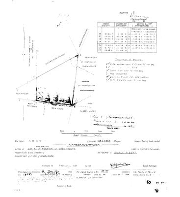 Surveyor-General diagram, 4241/1937, February 1937
101BEH01 1937.jpg
Cadastre
Surveyor-General diagram index for this parcel
Surveyor-General diagram index for the whole farm, where the original survey of this ground sits.
Research notes
Surveyed Feb 1937 by J.F.E. Hartwig (DOC-0085): "Portion 4 (Kareemoerhoek), a portion of Portion 2 [Lot A] of the farm Rhemhoogte No 125". Transferred 20.12.1937, deed 13528, to a transferee whose typed name is faint: "... born OOSTHUIZEN, married out of community of property to ... MARINCOWITZ" [TO VERIFY] (OWN-000063). Antecedent: dgms 1316/1883 and 1350/1883, Transfer Deed 341 of 25.1.1884 in favour of J.P. OOSTHUIZEN (OWN-000062). Cadastre 4/125 measures 1,561.7 ha vs 1,654.008 mg = 1,416.7 ha - 10% apart, LEAD-0007 discipline: do not present as confirming. Neighbours: Groot Sleutel Fontein (Rem.), Noorsdoringkop, Klein Botterkraal, Klein Plaats, MIDDLE WATER, Remr of Reimhoogte, Lot E.
[3 Aug 2026, SRC-208] ITS ANTECEDENT IS NOW HELD. This row cites 'dgms 1316/1883 and 1350/1883, Transfer Deed 341 of 25.1.1884 in favour of J.P. OOSTHUIZEN' without holding either diagram. 1350/1883 is now DOC-0174: Lot A of the subdivided Portion 1, 2108 morgen 338 sq roods, surveyed by P. S. Dale in July 1883, and its face carries Transfer 341 of 25.1.1884 - the same number and the same date. Kareemoerhoek is the LOT B named as its eastern neighbour.
[3 Aug 2026] ITS DIAGRAM NUMBER, from the verso of the Portion 2 sheet: KAART 4241/1937, survey record E.771/1937. The same line gives the extent as 1654,0080 morgen and the transfer as 13528/1937 - both of which this row already carried off the face of DOC-0085 - so the identification rests on three fields agreeing, not on one.
[13 Aug 2026] Renamed to the one form this model uses for every portion - the portion's own name, then the parent farm, its number and the portion in brackets - so that a name is legible in a list, a search result and a map popup without the reader having to know which farm number is which. It read "Kareemoerhoek (Rhemhoogte Ptn 4)" before. Nothing about the ground changed.
The research behind this page, kept separate from it: dated working notes, open questions, and what is not yet settled.
Open questions
-
match_cadastre.py no longer reproduces the geometry on disk
priority 1 · LEAD-0017
Re-running match_cadastre.py against the current CSVs changes 11 parcels and does not reproduce what is in parcels.csv. Which is right?
What would settle it Deciding per parcel whether the script's match or the hand entry is correct, then either fixing the script's name-matching or recording the hand values as deliberate.
-
Anna Margaretha Oosthuizen assembles three farms in one deed, 1937
priority 2 · LEAD-0040
On 20 December 1937 one transfer deed put Noorsdoringkop, Kleinbotterkraal and Kareemoerhoek into the name of Anna Margaretha Marincowitz, born Oosthuizen - over 10,240 morgen. Who assembled it, and with whose money?
What would settle it The deed itself: it names consideration and predecessor in title.
What the record is missing
-
53 years, and the ground changes hands to nobody we can follow
second order · B1 succession
On Kareemoerhoek (Rhemhoogte No. 125 Ptn 4), John Peter OosthuizenH is the last owner recorded from 1884-01-25, and the next entry is Anna Margaretha OosthuizenH from 1937-12-20, 53 years later, with no person in common. DOC-0085 records the later arrival but not the 53 years before it.
What would settle it The Deeds Office transfer register for this farm between 1884 and 1937. A transfer names its predecessor in title, so one deed closes the whole gap.
-
The record stops in 1937 and never resumes
third order · B2 trail-ends
Kareemoerhoek (Rhemhoogte No. 125 Ptn 4) was worked as far as 1937-12-20, with John Peter OosthuizenH the last owner on record. 89 years follow with nothing. Who held it after that, and is it still one farm?
What would settle it The current title deed traced backwards, each transfer names the one before it, or the Surveyor-General's subdivision diagrams, which are what usually explain a farm going quiet.
Found by breaks.py reading the model against itself, not written by hand,
each one is a shape of missing record, not a fault in the data.
The whole set is on the
questions page.