Surveyor-General diagram, 4241/1937, February 1937
Surveyor-General diagram, February 1937
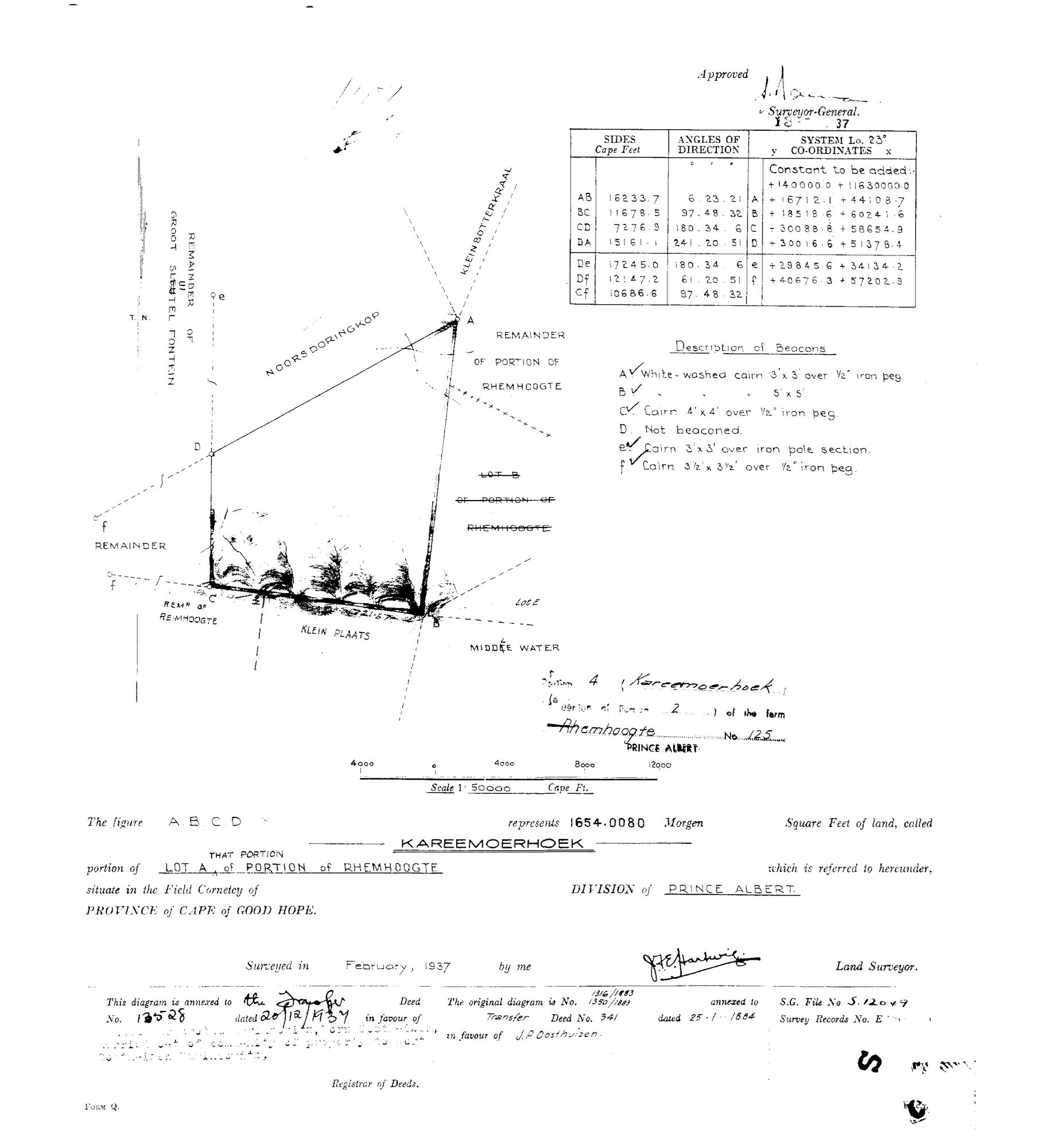
101BEH01 1937.jpg.The record
- Type
- Surveyor-General diagram
- Diagram number
- 4241/1937
- Surveyed
- February 1937
- Titled
- 20 December 1937
- Deed
- 13528
- Surveyor
- J.F.E. Hartwig
- Archive filename
- 101BEH01 1937.jpg
Citation
- Title
- Rhemhoogte Ptn 4 "Kareemoerhoek" diagram, 1937
- Repository
- Surveyor-General
- Reference
- SG Dgm -/1937
- Type
- SG diagram
The ground it is about
Kareemoerhoek (Rhemhoogte No. 125 Ptn 4)
Research notes
"Portion 4 (Kareemoerhoek), (a portion of Portion 2) of the farm Rhemhoogte No 125" - 1654.0080 morgen, "KAREEMOERHOEK, portion of LOT A, THAT PORTION of PORTION of RHEMHOOGTE", Division of Prince Albert. "This diagram is annexed to the Transfer Deed No. 13528 dated 20/12/1937 in favour of [typed, faint:] ...born Oosthuizen, married out of community of property to ... Marincowitz" [TO VERIFY - an Oosthuizen daughter marrying a Marincowitz]. "The original diagram is No. 1316/1883, 1350/1883 annexed to Transfer Deed No. 341 dated 25.1.1884 in favour of J.P. OOSTHUIZEN." Neighbours: Remainder of Groot Sleutel Fontein, Noorsdoringkop, Klein Botterkraal, Remainder/Lot B/Lot E of Rhemhoogte, Klein Plaats, MIDDLE WATER, Remr of Reimhoogte - note BOTH spellings Rhemhoogte and Reimhoogte on one face.
[3 Aug 2026] publish_ok=yes. This is an OLD FARM DIAGRAM held back only because a TRANSFER ENDORSEMENT on its face crosses the 1936 scan cut-off - the survey itself is from the 1920s or 1930s. The names on it are the surveyor, the neighbouring farms and a transferee of the 1930s or 1940, all long dead and most of them already published as person records here. Reviewed individually, not opened as a category.
[3 Aug 2026, SRC-208 verso] THE ILLEGIBLE NUMBER IS 4241/1937. This row has carried sg_diagram_no as "(number illegible)/1937" since the sheet was filed, because the number on the face could not be read. The deduction table on the back of the Portion 2 diagram (DOC-0174) gives it plainly, together with survey record E.771/1937, the extent 1654,0080 morgen and deed 13528/1937 - all three of which this model already held from the face, so the row is corroborated on four fields and identified on one.
The research behind this page, kept separate from it: dated working notes, open questions, and what is not yet settled.