Welbedagt Nr. 150 (Attaquaskloof, Oudtshoorn)
150 op die kadaster · op rekord 1753–1821 · wys op die kaart
- Plaasnommer
- Nr. 150
- Op die kadaster
- 150, heel plaasgeregistreer as WELBEDAGT
- Distrik
- Attaquaskloof (Olifants valley, Oudtshoorn division)
- Grootte, soos die kaart dit stel
- 2890 morgen, corrected 1890 to 3067 morgen 60 sq roods
- Moderne opgemete oppervlakte
- 2961.1 ha
Die historiese grootte en die moderne opgemete oppervlakte is twee aparte metings en word hier nie aangebied asof hulle mekaar bevestig nie. Die eerste is wat 'n landmeter op 'n kaart geskryf het, gewoonlik in morg. Die tweede is wat die moderne kadaster teken.
Waarom hierdie plaas hier is
Marthinus Oosthuizen (b.1743) het dit gehou. 58 km van Klaarstroom.
Marthinus Oosthuizen (b.1743) is regstreeks op hierdie grond aangeteken. Geen spoor nodig nie.
- dokument 'n Dokument in die versameling beskryf hierdie grond DOC-0306
- dokument 'n Dokument in die versameling beskryf hierdie grond DOC-0307
- dokument 'n Dokument in die versameling beskryf hierdie grond DOC-0378
- leidraad 'n Oop vraag in hierdie rekord gaan oor hierdie grond Do the levels need a second centre now that the prequel grounds carry their communities?
- …en nog 1, volledig gelys verder af op hierdie bladsy.
Wat die rekord hou, in volgorde
-
1753~ to 1778-04
ownership
Johannes Oosthuisen (omstreeks 1736–1782/)
loan farm · loan-farm register · confidence medium
-
1772 to 1780
ownership
Ockert Olivier d'oude
loan farm · loan-farm register · confidence medium
-
1780 to 1783
ownership
Marthinus Oosthuizen (b.1743) (1743–voor 1792-05-18)
loan farm · loan-farm register · confidence medium
-
1782~ to 1792-05-18
ownership
Marthinus Oosthuizen (b.1743) (1743–voor 1792-05-18)
loan farm · estate inventory · confidence high
-
18 Mei 1792
document
estate inventory
MOOC8/50.101a and 50.101b
-
18 Mei 1792
estate
Marthinus Oosthuizen (b.1743) (1743–voor 1792-05-18)
MOOC8/50.101a and 50.101b · Welbedagt, Attaquaskloof, aan de Oliphants Rivier
-
1821
document
SG diagram 219/1821
Geo.Q3-64
-
1821
document
SG diagram verso 219/1821 (general plan)
Ou.Q. 3-13
Begrens deur, soos die kaart hulle noem
- N Government ground ('About 500 Morgen of Govt Ground sweet Nature No Water')
- W Government ground along the Olifants ('3972 Morgen of Govt Ground sweet Nature'); 'Water Supply by the Oliphants River'
- E No. 57 Quitrent
- SE Quitrent No. 51
- S Barren Hills
Dokumente
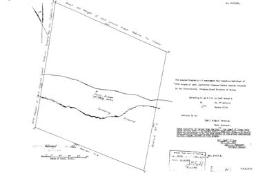 Landmeter-generaal-kaart, 219/1821, 1821
10Q9MG01 welbedacht oudtshoorn.jpg
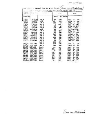 Kaart se keersy, 219/1821 (general plan), 1821
10Q9MH01 welbedacht oudtshoorn.jpg
Kadaster
Die Landmeter-generaal se kaartindeks vir hierdie perseel
Navorsingsnotas
THE OOSTHUYSEN LOAN PLACE ON THE SOUTHERN OLIFANTS. S.G. 219/1821 (SRC-469, DOC-0306) names it 'the LOANPLACE WELBEDAGT... in the fieldcornetcy ATTAQUAS KLOOF district of GEORGE', with 'Water Supply by the Olifants River' along its north-west boundary; the landholder in 1821 is Johannes Petrus Wagener.
MOOC8/50.101a and 50.101b (SRC-467) put MARTHINUS OOSTHUYSEN JANSZ (PER-001851) on 'de lenings plaats gen:t Welbedagt gelegen inde Attaquascloof aan de Oliphants Rivier', with TEN YEARS AND SIX MONTHS of arrear recognitie penningen owed on it - so held from about 1782 - and the farm inventory signed on the ground on 18 May 1792. He is a FIRST COUSIN of Ockert (PER-000118), and his brother WILLEM MARTHINUS (PER-001855) held the Modder Fenteijn on the Kafferkuils. LEAD-0223, closed.
NOT THE KOUP, and not core: this is the old Swellendam-then-George country the family came from, mapped here so the ground can be seen. 9a - a bounded set of records, not a second district to grow.
AREA: the cadastre gives 2,961 ha against the diagram's original 2,890 morgen (2,475 ha). The 1890 endorsement on the sheet itself resolves it - the Surveyor-General certified 3,067 morgen 60 sq roods, about 2,627 ha, as the true extent instead of 2,890. The polygon is larger again by a few per cent, which is what a chain-and-compass survey of 1821 read against modern coordinates does.
Verouderd: hieronder beantwoord [22 Sep 2026, SRC-665] APPEL: a 'Jan Oosthuysen (jr.)' farmed 'Webedagt aan die Rietfontein' for almost a quarter century and by April 1778 was so poor he could not pay 13 years and 11 months of arrears on the loan farm; the government let him suspend payment (RLR 18 p. 19). VERY PROBABLY THIS FARM: Rietfontein No. 154 lies 10.5 km from Welbedagt No. 150, and an Oosthuysen (Marthinus Jansz, a son of Jan Hendrik) holds this loan place from about 1782. So Welbedagt was an Oosthuysen place from about 1753, two generations before 1792. Which Jan it was is LEAD-0362.
Verouderd: hieronder beantwoord [22 Sep 2026] THE HAND-OVER IS DATED: Marthinus's 10 years 6 months of arrears in September 1792 put his holding from about MARCH 1782, the year his brother Johannes (PER-000739) died. So the farm runs Oosthuysen from about 1753 to 1792 without a break - a Jan to April 1778, then on to 1782, then Marthinus. Which Jan is LEAD-0362;
[22 Sep 2026, The Jan who held Welbedagt to April 1778 is JOHANNES (PER-000739), 'Jan d'jonge'; his brother Marthinus follows from about March 1782, the year Johannes died. LEAD-0362 closed.
[22 Sep 2026] 'AAN DIE RIETFONTEIN' IS THE FARM NEXT DOOR, and the distance objection was an artefact of measuring centroids. RIETFONTEIN No. 154 (Oudtshoorn) lies 10.5 km from this farm centre to centre but only 2.5 km EDGE TO EDGE: Welbedagt runs about 6 x 7 km and Rietfontein about 9 x 10, so the polygons very nearly touch. [FAMILY] 10.5km south west in those could have been neighbour. On a loan place that is the whole point - before survey a plaas was the opstal and about an hour's ride in each direction, and the ground between two of them belonged to nobody until it was granted later, which is what the strip between these two looks like. So Appel's 'Webedagt aan die Rietfontein' (SRC-665) names this farm by its neighbour and its water, the same way the 1792 estate names it 'in de Attaquascloof aan de Oliphants Rivier'. The identification now rests on three agreeing things: the Oosthuysen holding from about 1753 to 1792, the Attaquaskloof and the Olifants, and Rietfontein next door. RLR 18 p. 19 remains the confirmation, not an open question. AND THE QUITRENT NUMBERS ON THE 1821 SHEET ARE NOT FARM NUMBERS: 'No. 57 Quitrent' and 'Quitrent No. 51' cannot be Oudtshoorn farms 57 and 51, which lie 52 km and 35 km away. They are numbers in the George quitrent register.
[22 Sep 2026, SRC-666] A CANDIDATE FOR THE 1792-1821 GAP: the 1798 estate of Stephanus ter Blanche of Melkhoutekraal in Outeniqualand is owed 300 rixdollars by his son Johannes Ernst Terblanche Steph.z for the purchase of the opstal of 'de plaats Welbedagt' (MOOC8/22.44). The sheet does not say which Welbedagt and the name is common, so this is a candidate and not the answer [TO VERIFY]. Nothing else in the published MOOC8 names a Welbedagt in the Attaquaskloof besides the 1792 estate.
[22 Sep 2026, SRC-669] THE HOLDERS BEFORE MARTHINUS: Ockert Olivier was ordinansiehouer of 'Welbedagt aan die Olifantsrivier' in 1772 and the permit was re-issued to him in 1777 (RLR 22 pp. 49-50); M. Oosthuizen follows, 1780-1783 (RLR 27 p. 67). *** AND THAT RAISES A CONFLICT WITH APPEL, WHICH IS NOT RESOLVED. *** Appel has a Jan Oosthuysen on 'Webedagt aan die Rietfontein' for almost a quarter century, in arrears until April 1778 (SRC-665) - years in which this farm was Olivier's. Two readings: EITHER there are TWO Welbedagts and Appel's is elsewhere, which would undo this row's identification of it with Rietfontein No. 154; OR one farm was described by two waters and the two entries overlap for a reason not yet understood. The 1792 estate's own words, 'in de Attaquascloof aan de Oliphants Rivier', match Olivier's entry and not Appel's. UNRESOLVED [TO VERIFY]: what would settle it is a district or ward on RLR 18 p. 19.
*** [23 Sep 2026, FRANS] ONE FARM, NOT TWO, AND THE DOUBT WAS MINE. *** He put it plainly: Welbedagt is west of Oudtshoorn on the Olifants and was tagged here already. Both tests agree - PAR-000277 lies 19 km WEST of Oudtshoorn, and it is the ONLY Welbedagt on that river in the whole published MOOC8 (the others are at Buffeljags, Elandskloof, Drevers Vallei, Wagenmakersvallei, Kochelmanskloof, the Gouwersrivier, the Neysna in Outeniqualand and Uitenhage). SO APPEL'S 'WEBEDAGT AAN DIE RIETFONTEIN' IS THIS FARM, with Rietfontein No. 154 2.5 km off. WHAT I TREATED AS A CONTRADICTION IS TWO INSTRUMENTS: a loan place, whose arrears stood against Jan's name, and an ORDINANSIE, a permit, issued to Ockert Olivier in 1772 and re-issued in 1777. A debt outlives an occupation. The April 1778 entry is the government allowing the arrears to be suspended, not evidence that he was still farming it - his payments had stopped about 1764. WHAT IS STILL WORTH ASKING, and it is a detail rather than a doubt: when Jan actually left the ground, and what an ordinansie granted that a leningsplaats did not.
Werknotas, hier gewys omdat dit 'n private navorsingsbou is.
Die werksnotas op hierdie werf word in Engels gehou en word nie vertaal nie. Hulle verander met elke navorsingsessie, en 'n vertaling sou uit pas raak met die oorspronklike. Alles anders - die stories, die getranskribeerde dokumente en die koppelvlak - is in Afrikaans.
Oop vrae
-
Reconstruct the loan place Kandelaarsrivier (2945 morgen, 1818) from the farms it was cut into
prioriteit 1 · LEAD-0363
RLR 19 p. 94 (SRC-667) grants the loan place to Jacobus OosthuizenL, Jan's son. Which river is the 'Canalands', which of the two Gamtoos Bergs is the farm, and is the man PER-000230 (b. 1722, the direct ancestor) or a son of Jan Hendrik?
Wat dit sou uitmaak The register page, which should name the river and the ward.
-
Do the levels need a second centre now that the prequel grounds carry their communities?
prioriteit 2 · LEAD-0235
Frans admitted the Olifants communityand said 'we can keep our levels and that will help show relevance'. Under LEVELS.md as written those people land in LEVEL 4. Should R2 be pointed at a second centre, and what else comes in if it is?
Wat dit sou uitmaak Frans choosing between a second centre, a second centre plus the maternal one, and a separate time axis - after the numbers for each are measured rather than guessed.
-
Which Jan Oosthuysen held Welbedagt to April 1778 - Johannes (b. about 1736), most likely, or his father Jan Hendrik (b. 1714)?
prioriteit 2 · LEAD-0362
Appel (SRC-665, citing RLR 18 p. 19) has 'Jan Oosthuysen (jr.)' on Webedagt aan die Rietfontein for almost 25 years to April 1778, too poor to pay 13 years 11 months of arrears. Is 'jr.' the register's word or Appel's, and is the farm Welbedagt No. 150 (PAR-000277)?
Wat dit sou uitmaak The register's own entry, or a roll on which one of the two Jans still heads a household of substance after April 1778.
Wat die rekord kortkom
-
19 years, and the ground changes hands to nobody we can follow
first order · B1 succession
On Welbedagt Nr. 150 (Attaquaskloof, Oudtshoorn), Johannes OosthuisenH is the last owner recorded from 1753~, and the next entry is Ockert Olivier d'oude from 1772, 19 years later, with no person in common. No document records the handover at all.
What would settle it The Deeds Office transfer register for this farm between 1753 and 1772. A transfer names its predecessor in title, so one deed closes the whole gap.
-
The record stops in 1792 and never resumes
second order · B2 trail-ends
Welbedagt Nr. 150 (Attaquaskloof, Oudtshoorn) was worked as far as 1792-05-18, with Marthinus OosthuizenL (b.1743) the last owner on record. 234 years follow with nothing. Who held it after that, and is it still one farm?
What would settle it The current title deed traced backwards, each transfer names the one before it, or the Surveyor-General's subdivision diagrams, which are what usually explain a farm going quiet.
Found by breaks.py reading the model against itself, not written by hand,
each one is a shape of missing record, not a fault in the data.
The whole set is on the
questions page.