Van der Byls Kraal No. 265 (Beaufort West)
265 on the cadastre · on record 1831–1990 · show on the map
- Farm number
- No. 265
- Also recorded as
- Van der Byl's KraalSRC-721, the 1831 diagram] | Van der Byls Kraal [SRC-719, the 1861 death notice] | VAN DER BYLS KRAAL [the cadastre
- On the cadastre
- 265, whole farmregistered as VAN DER BYLS KRAAL
- District
- Beaufort West
- Extent, as the diagram states it
- 19 480 morgen (the 1831 survey)
- Modern surveyed area
- 10176.4 ha
The historic extent and the modern surveyed area are two separate measurements and are not presented here as confirming each other. The first is what a surveyor wrote on a diagram, usually in morgen. The second is what the modern cadastre draws.
Why this farm is here
Petrus Ernst Kruger (Diederik se seun) held it, and no kinship to the Oosthuizen, Marincowitz or Van der Merwe lines is recorded, this ground entered through the land, not the family. 123 km from Klaarstroom.
- document A document in the collection describes this ground DOC-0432
- document A document in the collection describes this ground DOC-0433
What the record holds, in order
-
November 1831
document
SG diagram B 355/1831
Bf.W.Q. 4-28, 31 December 1838
-
1831-11 to 1859-07-10
ownership
Petrus Ernst Kruger (Diederik se seun) (14 September 1786–10 July 1859)
quitrent · survey · confidence high
- 1990 document SG diagram verso B 355/1831 (verso)
Documents
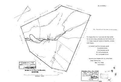 Surveyor-General diagram, B 355/1831, November 1831
SCAN627.TIF
SCAN628.TIF
Cadastre
Surveyor-General diagram index for this parcel
Research notes
[2 Nov 2026] THIS FARM SITS OUTSIDE THE SCOPE RULE AND IS HERE ON PURPOSE. 9a asks whether a thing moves the Klaarstroom basin, the arrival into the district, or a person who held ground in it. This one is about 100 km west of the basin and no family in this record holds it. It is kept for interest, and the exception is written down so that a later session does not mistake it for a working front. DO NOT GROW IT: no neighbours, no further Krugers, no van der Byl line.
*** WHAT IT IS. *** Van der Byls Kraal No. 265, Beaufort West division, surveyed November 1831 by C.G. Ochse for PETRUS ERNST KRUGER DIEDERIK SON (SRC-721, DOC-0432), 19 480 morgen, in the Field Cornetcy of P.E. Kruger, Gouph. Quitrent title Bf.W.Q. 4-28 of 31 December 1838. MERWEVILLE WAS LAID OUT ON IT, about 2 km from the farm's centre; PLC-000067 already carried that as a cadastre check made 14 Aug 2026.
*** THE NAME IS OLDER THAN THE KRUGERS. *** Death notice 8321 of 1861 (SRC-719) gives Pieter Ernst KrugerM's birthplace as Van der Byls Kraal and he was born 14 September 1786, so the name was on the ground 45 years before the survey. His joint will of 10 July 1818 was signed at Dolfs Kraal 'adjacent to Van der Byls Kraal' (SRC-717). WHO THE VAN DER BYL WAS IS NOT KNOWN. Two documents put a Piet van der Byl on frontier ground in the right decades and neither is on this farm: a Roggeveld raid report listing '53 beesten' lost by him (SRC-717), and MOOC8/23.10 of 1798 where he owes for the opstal of a loan place called Quaggas Vally in the Graaff-Reinet colony (SRC-718). The loan farm registers at Roeland Street are where the name will be.
*** THE PLC IS THE DISTRICT, NOT THE WARD, ON PURPOSE. *** The diagram puts it in P.E. Kruger's Gouph cornetcy, and PLC-000020 is a Koup field cornetcy with M. de BeerM named for 1833-34. The 1824 roll (SRC-634) shows FOUR wards called Couph under different cornets, so Kruger's and de Beer's need not be the same unit and this row does not assert it.
The cadastral parcel today is about 10 184 ha against the 1831 survey's 16 685, because the verso's DEDUCTION table shows three portions cut off: 9 740 morgen in 1877, 4 040 morgen 558 roods in 1882 and 2 835 morgen 533 roods in 1884 (DOC-0433). The gap between the 1831 extent and the modern polygon is those deductions and is not a mismatch. [TO VERIFY]
The research behind this page, kept separate from it: dated working notes, open questions, and what is not yet settled.
What the record is missing
-
The record stops in 1859 and never resumes
second order · B2 trail-ends
Van der Byls Kraal No. 265 (Beaufort West) was worked as far as 1859-07-10, with Petrus Ernst KrugerH (Diederik se seun) the last owner on record. 167 years follow with nothing. Who held it after that, and is it still one farm?
What would settle it The current title deed traced backwards, each transfer names the one before it, or the Surveyor-General's subdivision diagrams, which are what usually explain a farm going quiet.
Found by breaks.py reading the model against itself, not written by hand,
each one is a shape of missing record, not a fault in the data.
The whole set is on the
questions page.