Matjes Fontein No. 712
· on record 1885 · show on the map
- Farm number
- No. 712
- District
- Calvinia (division)
- Extent, as the diagram states it
- 10340 morgen 242 sq roods
- Modern surveyed area
- 4450.6 ha
The historic extent and the modern surveyed area are two separate measurements and are not presented here as confirming each other. The first is what a surveyor wrote on a diagram, usually in morgen. The second is what the modern cadastre draws.
Why this farm is here
Ground a written history is set on. 282 km from Klaarstroom.
- story A written history names this ground The van der Merwes of the Hantam
- document A document in the collection describes this ground DOC-0284
- lead An open question in this record is about this ground Which Matjiesfontein was Frans Jacobus Wilhelmus van der Merwe born on in 1863?
- lead An open question in this record is about this ground Eight scans filed from the 19 August inbox, hints read and cadastre located, images not yet read
Stories
- mentions this farm
The van der Merwes of the Hantam
The maternal line, from Paarl in 1735 to Vredendal in about 1950, with every kinship spelled out. The crossing from the Piketberg district into the Hantam is dated to a fourteen-year window by two death notices; three farms were surveyed for the Commissie van Inspectie by one man in 1820 and 1823; a man called Kwaai Koos is named after his farm; and twice in three generations the family is standing on ground that came in through a woman.
What the record holds, in order
- 1885 document SG diagram 1908/1885
Documents
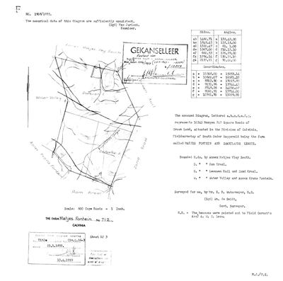 Surveyor-General diagram, 1908/1885, 1885
10055127 712.jpg
Research notes
[10 Aug 2026, SRC-370/DOC-0284] A MATJESFONTEIN IN THE CALVINIA DIVISION, AND NOT THE ONE. This row was created as the birthplace of Frans Jacobus Wilhelmus van der MerweL (PER-000762, b. 24 March 1863) and the identification was withdrawn the same day; three separate arguments against it are recorded below. THE HEADING SAID OTHERWISE UNTIL 18 AUG 2026 - the withdrawals sat eight hundred characters further down, so a reader met the claim first and the retraction last, which is the fault the Citrusdal rows were corrected for on the same day. S.G. 1908/1885 calls it 'the farm called MATJES FONTEIN AND ZWARTLANDS LEEGTE', 10340 morgen 242 roods of Crown Land, FIELDCORNETCY OF SOUTH ONDER ROGGEVELD - a third cornetcy, after Tygerhoek's Voor Hantam and Oude Muur's Onder Bokkeveld. Surveyed for Wm. de Smidt by E. B. Watermeyer; examiner Max Jurisch, the same man who examined Middelwater's 1883 resurvey. Beacons pointed out to Field Cornet's Assistant A. W. S. LOUW. Title Clv. Q. 16-3 of 23.1.1893. Bounded N by Annex Matjes Vley South, S by Ram Kraal, E by Leeuwen Kuil and Zand Kraal, W by Water Valley and Annex Krans Fontein. Stamped GEKANSELLEER, superseded by kaart 3256/1958. THE CADASTRE SPELLS IT MATJESFONTEIN, WITHOUT THE I. This project searched for Matjiesfontein and found nothing; the farm was there all along under the other spelling.
[10 Aug 2026] THIS FARM IS NOT ESTABLISHED AS THE BIRTHPLACE. The row was created this morning with a note tying it to PER-000762's birth in 1863; that tie rested on the name and the district and nothing else. There are at least twelve Matjiesfonteins in the Northern Cape, five of them in the FRASERBURG division, and The sheet and the farm are real and stay; the identification is withdrawn. LEAD-0151.
[11 Aug 2026] MEASURED: this farm lies 111.6 km from Oude Muur, which makes it the second furthest of the seven Calvinia Matjesfonteins from the ground this family held. Three others - 601, 791 and 679 - lie within 24 km of Oude Muur. It was entered here because it was the Matjesfontein this project found first, not because anything tied it to the family, and the withdrawn pin stays withdrawn. LEAD-0151.
[16 Aug 2026, MED-000104] A THIRD ARGUMENT AGAINST THIS FARM, and it comes from outside the family papers. The Calvinia museum panel draws a Matjes Fonteijn among the district's old farms in the SOUTH-WEST, just north of Lokenburg and beside Oorlogskloof. This farm is at longitude 20.44; Lokenburg is at 19.18 and Oude Muur at 19.29. 120 km apart. The withdrawn identification stays withdrawn.
[18 Aug 2026] AND NOW THERE IS A BETTER CANDIDATE ON THE MAP BESIDE IT. PAR-000280, MATJESFONTEIN No. 791, lies in the ONDER BOKKEVELD - the same field cornetcy and drostdy as Lokenburg, where Anna Jacoba LouwM died - about 21 km from it, against this farm's 112 km. Its 1834 diagram is read (SRC-477) and its holder, Daniel Jacobus Louw Danielszoon, owed Anna Jacoba's mother rd 2,000 (SRC-368). None of that identifies a birthplace either, and both farms stay on the map as what they are: candidates, one much closer than the other.
The research behind this page, kept separate from it: dated working notes, open questions, and what is not yet settled.
Open questions
-
Which Matjiesfontein was Frans Jacobus Wilhelmus van der Merwe born on in 1863?
priority 1 · LEAD-0151
FamilySearch records his birth on 24 March 1863 at 'Matjiesfontein, Calvinia'. The Northern Cape cadastre holds at least twelve farms of that name. Which one, and is it even in the Calvinia division?
What would settle it The transfer history of Matjesfontein No. 791 between deed Clw.Q.3-16 of 1 November 1838 and 1863, which would say who held it when Frans Jacobus Wilhelmus was born there. Failing that, the Calvinia baptism register entry for 24 March 1863, which may name the farm. | Calvinia 601 and 679 remain unread, and the Fraserburg cluster is still the other candidate.
-
Eight scans filed from the 19 August inbox, hints read and cadastre located, images not yet read
priority 2 · LEAD-0240
Eight of the twelve files that arrived on 19 Aug 2026 are filed and identified by their filename hint but have not been opened. What is on them?
What would settle it Reading them.
What the record is missing
-
Nobody is on record as ever having held this
third order · B8 never-held
Matjes Fontein No. 712 is in the model and drawn on the map, and carries no ownership record of any kind, not a grant, not a transfer, not an occupation.
What would settle it The Surveyor-General's diagram for the farm number names the grantee and the date; the deed reference on it opens the transfer chain.
Found by breaks.py reading the model against itself, not written by hand,
each one is a shape of missing record, not a fault in the data.
The whole set is on the
questions page.