Fontyn No. 70 (Uniondale)
· on record 1832 · show on the map
- Farm number
- No. 70
This parcel has no matched survey polygon, so it cannot be drawn on the map. That is a gap in the cadastre match, not an absence from the record.
Why this farm is here
Described by a document in this collection. Not yet placed on the map.
- document A document in the collection describes this ground DOC-0343
- document A document in the collection describes this ground DOC-0358
What the record holds, in order
- 1832 document SG diagram 342/1832
- 1832 document SG diagram verso 342/1832 (verso)
Documents
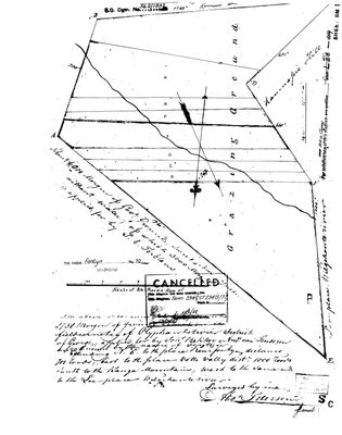 Surveyor-General diagram, 342/1832, 1832
10615796.jpg
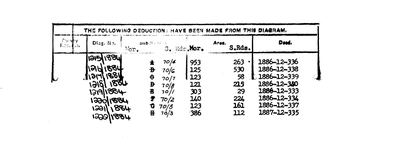 Diagram verso, 342/1832 (verso), 1832
10615798.jpg
Research notes
SG diagram 342/1832 (DOC-0343), 'fieldcornetcy of Olyphantsrivier'. Adjoins Wilgehoute Rivier No. 69.
[16 Sep 2026] THE TERBLANS APPLICATIONS. Fontyn's own sheet (DOC-0343) names Johs Bekker and Andrs van Tonderen as applicants for these 2738 morgen, 'known by the name of Fontyn', and notes a further 3000 morgen of waterless government ground applied for by [?J.] E. Terblans; the Wilgehoute Rivier sheet of the same run (DOC-0342) calls the same 2738 morgen 'vacant grazing applied for by Terblans'. In the George roll of 1823 (SRC-638, image 327) Salomon Terblans of Modder Fontyn is the 11th household, Johannes Bekker the 12th and Antonie Petrus van Tonderen x Petronella Bekker the 7th, so the three families were neighbours nine years before the survey. Fontyn itself was VACANT GRAZING in 1832 and cannot be the 1823 Modder Fontyn, which carried 8,500 vines; it is the dry ground beside Terblans's place. [TO VERIFY] which neighbouring farm Modder Fontyn was. Deduction table DOC-0358.
The research behind this page, kept separate from it: dated working notes, open questions, and what is not yet settled.
What the record is missing
-
Nobody is on record as ever having held this
third order · B8 never-held
Fontyn No. 70 (Uniondale) is in the model, and carries no ownership record of any kind, not a grant, not a transfer, not an occupation.
What would settle it The Surveyor-General's diagram for the farm number names the grantee and the date; the deed reference on it opens the transfer chain.
Found by breaks.py reading the model against itself, not written by hand,
each one is a shape of missing record, not a fault in the data.
The whole set is on the
questions page.