Vogelstruis Leegte Lot B No. 38
· on record 1862 · show on the map
- Farm number
- No. 38
- District
- Willowmore
- Extent, as the diagram states it
- 5136 morgen 73 square roods
- Modern surveyed area
- 4468.3 ha
The historic extent and the modern surveyed area are two separate measurements and are not presented here as confirming each other. The first is what a surveyor wrote on a diagram, usually in morgen. The second is what the modern cadastre draws.
Why this farm is here
Described by a document in this collection. 87 km from Klaarstroom.
- document A document in the collection describes this ground DOC-0334
- document A document in the collection describes this ground DOC-0335
- document A document in the collection describes this ground DOC-0336
- document A document in the collection describes this ground DOC-0337
What the record holds, in order
- 1862 document SG plan 1911/1862
-
October 1862
document
SG diagram 1732/1863
P.A.Q.2-9
-
October 1862
document
SG diagram 1732/1863 (Part 2)
P.A.Q.2-9
- undated document SG diagram verso 1732/1863 (verso)
Also bordered by, as the modern cadastre draws it
Ground that touches this farm on the Surveyor-General's current polygons and that none of the diagrams held here names. Derived from the geometry, not read off a document.
Documents
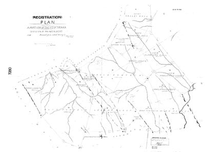 SG_plan, 1911/1862, 1862
10777904 Willowmore district.jpg
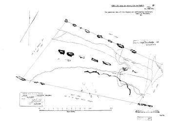 Surveyor-General diagram, 1732/1863, October 1862
10KZ2B01 willowmore 38.jpg
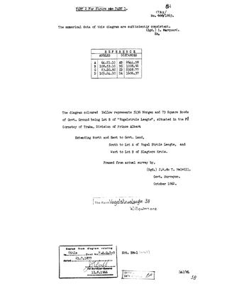 Surveyor-General diagram, 1732/1863 (Part 2), October 1862
10KZ2D01 willowmore 38.jpg
 Diagram verso, 1732/1863 (verso)
10KZ2C01 willowmore 38.jpg
Research notes
[SRC-550] Drawn on SG 1911/1862, the (Registration) Plan of a portion of the FIELD CORNETCY OF TRAKA, Division of Prince Albert, framed from actual survey 1862 and stamped ADMIN DISTRICT WILLOWMORE. The Traka field cornetcy is PLC-000022 and straddles the Prince Albert / Willowmore boundary; the registration division here is Willowmore (C0830000), NOT Prince Albert, and a farm number is only unique inside a division. NO FAMILY HOLDING IS RECORDED ON THIS GROUND - the parcel is entered because the plan documents it, not because anybody here held it. [SRC-551] Its own diagram 1732/1863 states: 5136 Morgen and 73 Square Roods of Govt. Ground being LOT B of "Vogelstruis Leegte", in the Fd Cornetcy of Traka, Division of Prince Albert - extending North and East to Govt. Land, South to Lot A of Vogel Struis Leegte, West to Lot B of Slagters Kruis. Framed from actual survey by J.W. du T. MelvillM, Govt. Surveyor, OCTOBER 1862, examined L. MarquardM; title deed P.A.Q.2-9 of 21.7.1877. THE SAME SURVEYOR AND EXAMINER, AND THE SAME P.A.Q. DEED SERIES, AS RONDABEL No. 124 (DOC-0024, P.A.Q.1-21) - one survey campaign over this district between 1859 and 1864.
The research behind this page, kept separate from it: dated working notes, open questions, and what is not yet settled.
What the record is missing
-
Nobody is on record as ever having held this
third order · B8 never-held
Vogelstruis Leegte Lot B No. 38 is in the model and drawn on the map, and carries no ownership record of any kind, not a grant, not a transfer, not an occupation.
What would settle it The Surveyor-General's diagram for the farm number names the grantee and the date; the deed reference on it opens the transfer chain.
Found by breaks.py reading the model against itself, not written by hand,
each one is a shape of missing record, not a fault in the data.
The whole set is on the
questions page.