Wilgehoute Rivier No. 69 (Uniondale)
· on record 1832 · show on the map
- Farm number
- No. 69
- Also recorded as
- Wilgehoute Rivier; Wilgehoute River
- Modern surveyed area
- 269.4 ha
Why this farm is here
Here because an open question in this record is about it; who held it is not yet established. 49 km from Klaarstroom.
- document A document in the collection describes this ground DOC-0342
- lead An open question in this record is about this ground The Veldkornetskap Oliphants Rivier farms - is this family tied to any of them beyond its own place?
- lead An open question in this record is about this ground Sheet 1 of the Wilgehoute Rivier diagram, and the loan place Wilgerivier
What the record holds, in order
- 1832 document SG diagram 341/1832
Also bordered by, as the modern cadastre draws it
Ground that touches this farm on the Surveyor-General's current polygons and that none of the diagrams held here names. Derived from the geometry, not read off a document.
Documents
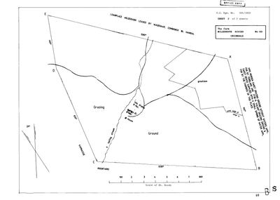 Surveyor-General diagram, 341/1832, 1832
10DU4X01.jpg
Cadastre
Surveyor-General diagram index for this parcel
Research notes
The VELDKORNETSKAP OLIPHANTS RIVIER of the George district, named and listed on George opgaafrol J 91 (SRC-525). Added after that page identified the country the family's Olifants farms lay in. PREQUEL GROUND under 9a - the Oosthuizen road into the Koup - and NEVER `core`, so it must not move the map's opening bounds. Read by Frans in the same section.
The research behind this page, kept separate from it: dated working notes, open questions, and what is not yet settled.
Open questions
-
The Veldkornetskap Oliphants Rivier farms - is this family tied to any of them beyond its own place?
priority 2 · LEAD-0270
Eleven Uniondale farms from the George rolls are now on the map - Nietgenaamd 9, Gorgida 14, Misgund 25, Moerasfontein 27, Keurfontein 45, Wilge River 46, Schoongezigt 52, Roodeheuvel 55, Diepe Kloof 56, Buffels Klip 63, Wilgehoute Rivier 69. *** NOT ONE OF THEM CARRIES A SINGLE OWNERSHIP ROW OR A NAMED HOLDER IN THIS MODEL. *** They are neighbours read off a roll, pinned to a cadastre. Is there any actual family tie to them, or only to Wanhoop and Modderfonteyn?
What would settle it A named holder on one of those eleven farms who is already a person here, or marries one.
-
Sheet 1 of the Wilgehoute Rivier diagram, and the loan place Wilgerivier
priority 3 · LEAD-0301
DOC-0342 is marked SHEET 2 OF 2 and sheet 1 is not held. Its northern legend reads 'LOANPLACE WILGERIVIER LEASED BY WAGENAAR, COMBRINCK & HANIBAL' - three lessees on one loan place, which is unusual enough to be worth the sheet that explains it.
What would settle it The first sheet.
What the record is missing
-
Nobody is on record as ever having held this
third order · B8 never-held
Wilgehoute Rivier No. 69 (Uniondale) is in the model and drawn on the map, and carries no ownership record of any kind, not a grant, not a transfer, not an occupation.
What would settle it The Surveyor-General's diagram for the farm number names the grantee and the date; the deed reference on it opens the transfer chain.
Found by breaks.py reading the model against itself, not written by hand,
each one is a shape of missing record, not a fault in the data.
The whole set is on the
questions page.