Keurfontein No. 45 (Uniondale)
· on record 1935 · show on the map
- Farm number
- No. 45
- Also recorded as
- Keurfonteyn; Kleurfontein; Keurfontein
- Modern surveyed area
- 3558.2 ha
Why this farm is here
Here because an open question in this record is about it; who held it is not yet established. 52 km from Klaarstroom.
- document A document in the collection describes this ground DOC-0345
- lead An open question in this record is about this ground The Veldkornetskap Oliphants Rivier farms - is this family tied to any of them beyond its own place?
What the record holds, in order
- February 1935 document SG diagram
Also bordered by, as the modern cadastre draws it
Ground that touches this farm on the Surveyor-General's current polygons and that none of the diagrams held here names. Derived from the geometry, not read off a document.
Documents
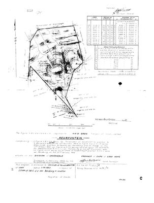 Surveyor-General diagram, February 1935
10TOFU01.jpg
Cadastre
Surveyor-General diagram index for this parcel
Research notes
The VELDKORNETSKAP OLIPHANTS RIVIER of the George district, named and listed on George opgaafrol J 91 (SRC-525). Added after that page identified the country the family's Olifants farms lay in. PREQUEL GROUND under 9a - the Oosthuizen road into the Koup - and NEVER `core`, so it must not move the map's opening bounds. Entry 201, held by Pieter Willem Nel with H. Bekker. The roll's spelling varies between Keurfonteyn and Kleurfontein.
The research behind this page, kept separate from it: dated working notes, open questions, and what is not yet settled.
Open questions
-
The Veldkornetskap Oliphants Rivier farms - is this family tied to any of them beyond its own place?
priority 2 · LEAD-0270
Eleven Uniondale farms from the George rolls are now on the map - Nietgenaamd 9, Gorgida 14, Misgund 25, Moerasfontein 27, Keurfontein 45, Wilge River 46, Schoongezigt 52, Roodeheuvel 55, Diepe Kloof 56, Buffels Klip 63, Wilgehoute Rivier 69. *** NOT ONE OF THEM CARRIES A SINGLE OWNERSHIP ROW OR A NAMED HOLDER IN THIS MODEL. *** They are neighbours read off a roll, pinned to a cadastre. Is there any actual family tie to them, or only to Wanhoop and Modderfonteyn?
What would settle it A named holder on one of those eleven farms who is already a person here, or marries one.
What the record is missing
-
Nobody is on record as ever having held this
third order · B8 never-held
Keurfontein No. 45 (Uniondale) is in the model and drawn on the map, and carries no ownership record of any kind, not a grant, not a transfer, not an occupation.
What would settle it The Surveyor-General's diagram for the farm number names the grantee and the date; the deed reference on it opens the transfer chain.
Found by breaks.py reading the model against itself, not written by hand,
each one is a shape of missing record, not a fault in the data.
The whole set is on the
questions page.