Buffelsfontein No. 36 (Ladismith)
36 on the cadastre · on record 1832 · show on the map
- Farm number
- No. 36
- Also recorded as
- Buffels Fontein; Buffelsfontein
- On the cadastre
- 36, whole farmregistered as BUFFELSFONTEIN
- Modern surveyed area
- 1389.6 ha
Why this farm is here
A burial ground stands on this farm, which is how it enters this record. 139 km from Klaarstroom.
- document A document in the collection describes this ground DOC-0329
- burial A burial ground stands on this farm Buffelsfontein 36, farm cemetery (Ladismith district)
What the record holds, in order
- 1 September 1832 document SG diagram 483/1832
Buried on this ground
- Buffelsfontein 36, farm cemetery (Ladismith district) 0 graves recorded
The burials also appear on this farm's timeline above, each at its own date.
Also bordered by, as the modern cadastre draws it
Ground that touches this farm on the Surveyor-General's current polygons and that none of the diagrams held here names. Derived from the geometry, not read off a document.
Documents
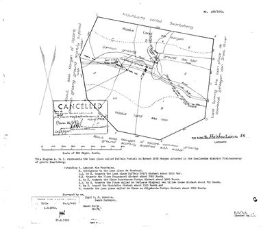 Surveyor-General diagram, 483/1832, 1 September 1832
SCAN698.jpg
Cadastre
Surveyor-General diagram index for this parcel
Research notes
SG diagram 483/1832 (DOC-0329, SRC-506): the loan place BUFFELS FONTEIN, 2090 morgen, Swellendam district, Field-cornetcy of Groote Swarteberg, surveyed by H. F. Schutte. CONTIGUOUS TO VOORBAAT and says so; Voorbaat's own sheet says the same of it, and the two diagram numbers are consecutive - 482 and 483 of 1832, one surveyor, one visit.
*** ITS BURIAL GROUND CARRIES AN OOSTHUIZEN MARRIAGE. *** CEM-514 sits 0.6 km from this farm's centroid and reads 'ZYL Gerrit Johannes, van 1771-1875 & Catherina OOSTHUIZEN'. GERRIT JOHANNES is a name this family uses - Gerrit Johannes OosthuizenM (PER-000239, b. 10 Feb 1760), son of Jacobus OosthuizenL and Dina Carolina BritzM - and a van Zyl carrying it beside a van Zyl who married an Oosthuizen is the vernoemingspatroon pointing at a mother. NO DESCENT ASSERTED. LEAD-0256. The caption also reads 1771-1875, a 104-year lifespan, so it is a misread or two people on one stone.
Named neighbours: de Voorbaat (E), Buffels Drift, Knuyspoort, Boureboone Fontyn, de Verlaate Miskraal van Willem Goose, de Miere en Wilgehoute Fontyn.
NOT CORE AND NOT IN THE KOUP: no plc_id, so scope.in_koup fails closed and the map's opening bounds stay on Klaarstroom. 9a - a prequel ground is drawn so the road can be seen, never grown into a second district.
The research behind this page, kept separate from it: dated working notes, open questions, and what is not yet settled.
What the record is missing
-
Nobody is on record as ever having held this
third order · B8 never-held
Buffelsfontein No. 36 (Ladismith) is in the model and drawn on the map, and carries no ownership record of any kind, not a grant, not a transfer, not an occupation.
What would settle it The Surveyor-General's diagram for the farm number names the grantee and the date; the deed reference on it opens the transfer chain.
Found by breaks.py reading the model against itself, not written by hand,
each one is a shape of missing record, not a fault in the data.
The whole set is on the
questions page.