Voorbaat No. 42 (Ladismith)
42 on the cadastre · on record 1832 · show on the map
- Farm number
- No. 42
- Also recorded as
- Voorbaat; De Vorbaat; de Voorbaat
- On the cadastre
- 42, whole farmregistered as VOORBAAT
- Extent, as the diagram states it
- 1740 morgen 50 square roods (SG 482/1832)
- Modern surveyed area
- 1460.7 ha
The historic extent and the modern surveyed area are two separate measurements and are not presented here as confirming each other. The first is what a surveyor wrote on a diagram, usually in morgen. The second is what the modern cadastre draws.
Why this farm is here
Here because an open question in this record is about it; who held it is not yet established. 136 km from Klaarstroom.
- document A document in the collection describes this ground DOC-0328
- burial A burial ground stands on this farm Voorbaat 42, Voorbaat cemetery (Ladismith district)
- lead An open question in this record is about this ground Put a ruler across the 1805 opening: whose farm is Modderfontyn?
- lead An open question in this record is about this ground Are the Stassens of Voorbaat descended from the 1814 Oosthuizen marriage?
- …and 1 more, listed in full further down this page.
What the record holds, in order
- 1832 document SG diagram 482/1832
Buried on this ground
- Voorbaat 42, Voorbaat cemetery (Ladismith district) 0 graves recorded
The burials also appear on this farm's timeline above, each at its own date.
Also bordered by, as the modern cadastre draws it
Ground that touches this farm on the Surveyor-General's current polygons and that none of the diagrams held here names. Derived from the geometry, not read off a document.
Documents
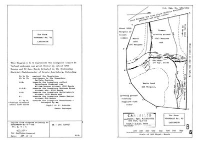 Surveyor-General diagram, 482/1832, 1832
10427522.jpg
Cadastre
Surveyor-General diagram index for this parcel
Research notes
*** SG DIAGRAM 482/1832 (DOC-0328, SRC-505) NOW NAMES IT OUTRIGHT: 'the loanplace called DE VORBAAT GELEEGEN AAN GROOT REVIER in extent 1740 Morgen and 50 Sqr. Roods Situated in the SWELLENDAM DISTRICT FIELDCORNETCY OF GROOTE SWARTEBERG'. *** Surveyed by H. F. Schutte. Extent agrees with the modern polygon: 1740 morgen is about 1,491 ha against the cadastre's 1,459.7. Cancelled 17 Oct 1967, superseded by Dgm B.536/1872.
CONTIGUOUS TO BUFFELSFONTEIN NO. 36 (PAR-000293), which its own diagram 483/1832 confirms from the other side. Other named neighbours: Deverlaate Miskraal van Willem Goosen, Baviaan Krans, Buffelsdrift, Dwars Revier, Boureboone-Fonteyn.
*** AND THE GROOT RIVER ANSWERS A QUESTION FROM 19 AUGUST. *** Reading the 1808 roll The Groot River is named twice on this sheet and runs through this farm; Ockertskraal lies 20 km south-west on the Touw.
NAMED IN THE FARM COLUMN OF THE 1805 SWELLENDAM OPGAAFROL - SRC-497, image 42, reads '1. Voorbaat' on the same opening that carries the Oosthuizen entries. WHICH HOUSEHOLD HELD IT IS STILL NOT ESTABLISHED. LEAD-0246.
THE BURIAL GROUND ON IT IS CEM-520, thirty-nine named graves, more than half of them STASSEN - and the private tree holds exactly one Oosthuizen-Stassen marriage in 44,143 people: Frans Johannes Nicolaas Stassen and PETRONELLA HERMINA JACOBA HENDRIKA OOSTHUIZEN (1793-1873), about 1814, she a granddaughter of Jacobus OosthuizenL (PER-000230) and Dina Carolina BritzM and a first cousin of Ockert Almero. LEAD-0255.
NOT CORE AND NOT IN THE KOUP: no plc_id, so scope.in_koup fails closed and the map's opening bounds stay on Klaarstroom. 9a - a prequel ground is drawn so the road can be seen, never grown into a second district.
The research behind this page, kept separate from it: dated working notes, open questions, and what is not yet settled.
Open questions
-
Put a ruler across the 1805 opening: whose farm is Modderfontyn?
priority 1 · LEAD-0246
Image 41 of film 008145384 carries Oosthuizen entries 776-790, among them 784 OCKERT with Susanna Catharina van TonderMen and 789 OCKT: ALMERO. The facing leaf, image 42, carries the farm column: de Wolve Fonteyn, aan d' Vals Rivier en d' Berg Rivier of Fo[ntein], de groote Heuvel en d' Buffels Fo[ntein], MODDERFONTYN, Voorbaat, Riet Valey. Which farm row reads across to which entry?
What would settle it A ruled line traced from an entry number on the left leaf to a farm row on the right leaf. Nothing less. The two leaves currently held are screenshots at different zooms.
-
Are the Stassens of Voorbaat descended from the 1814 Oosthuizen marriage?
priority 1 · LEAD-0255
Voorbaat cemetery, Ladismith (CEM-520), is more than half Stassen and repeats the name FRANS JOHANNES NICOLAAS STASSEN at 1852-1939, 1904-1984 and 1935-2000. The private tree holds one Oosthuizen-Stassen marriage: Frans Johannes Nicolaas Stassen, b. about 1789, and Petronella Hermina Jacoba Hendrika Oosthuizen, 1793-1873, about 1814. Do the Voorbaat Stassens come down from that couple?
What would settle it One document linking the 1852 Stassen to the 1814 couple. The name recurrence alone cannot do it.
-
The Ladismith burial grounds repeat this family's marriages, not just its surname
priority 1 · LEAD-0256
[FAMILY] Any other cemetery in ladismith area with Oosthuizen, or first names combinations that repeat in Oosthuizen tree? Five Ladismith grounds carry Oosthuizen graves. Are these the same family, and which of the marriages the stones show are already in this record?
What would settle it A death notice or baptism naming parents for any one of: Catherina Oosthuizen who married a Gerrit Johannes van Zyl; Michiel J. Oosthuizen 1881-1945; Catharina Hendrina Oosthuizen 1879-1957.
What the record is missing
-
Nobody is on record as ever having held this
third order · B8 never-held
Voorbaat No. 42 (Ladismith) is in the model and drawn on the map, and carries no ownership record of any kind, not a grant, not a transfer, not an occupation.
What would settle it The Surveyor-General's diagram for the farm number names the grantee and the date; the deed reference on it opens the transfer chain.
Found by breaks.py reading the model against itself, not written by hand,
each one is a shape of missing record, not a fault in the data.
The whole set is on the
questions page.