Rietkuil No. 119 (Kouka)
119 on the cadastre · on record 1833–1841 · show on the map
- Farm number
- No. 119
- On the cadastre
- 119, whole farmregistered as RIETKUIL
- District
- Prince Albert
- Extent, as the diagram states it
- 14 379 morgen (loan farm plus annexed Government ground)
- Modern surveyed area
- 12825.6 ha
The historic extent and the modern surveyed area are two separate measurements and are not presented here as confirming each other. The first is what a surveyor wrote on a diagram, usually in morgen. The second is what the modern cadastre draws.
Why this farm is here
Pieter Johannes Swanepoel (b6c5d7) lived on this ground. Connected to the Oosthuizen, Marincowitz or Van der Merwe lines BY MARRIAGE, not by blood, 4 steps on the shortest path. 42 km from Klaarstroom.
- Pieter Johannes Swanepoel (b6c5d7)
- married to Johanna Jacomina Petronella Catharina Venter
- child of Jan Adriaan Venter
- parent of Willem Venter
- married to Anna Christina Oosthuizen
Each step is a recorded parentage or marriage in this model, and the shortest one the record supports, follow the names to check it.
- story A written history is set on this ground On 15 April 1841 loan ground becomes property
- story A written history names this ground The ground cut, and then stitched back together
- border Shares a boundary with Van Aardsfontein No. 109 Van Aardsfontein No. 109
- border Shares a boundary with Klipgat No. 114 Klipgat No. 114
- …and 1 more, listed in full further down this page.
Stories
- about this farm
On 15 April 1841 loan ground becomes property
One surveyor works the Koup for two seasons. Seven years later, on a single day, the Crown converts the loan farms to perpetual quitrent: twenty-one deeds on twenty parcels, and the map of the district is set for a century.
- mentions this farm
The ground cut, and then stitched back together
This project holds 124 boundary acts: 96 subdivisions and 20 consolidations. Sorted by date they tell one story with a turning point. The district cut ground for a hundred and fifty years; from 1970 it has only stitched.
What the record holds, in order
-
September 1833
document
SG diagram 361/1833
Bf.W.Q. 3-35
-
1837
lived here
Pieter Johannes Swanepoel (b6c5d7) (13 February 1799–26 March 1885)
farming
-
1841-04-15 to 1885-03-26
ownership
Pieter Johannes Swanepoel (b6c5d7) (13 February 1799–26 March 1885)
quitrent · grant · confidence high
Bordered by, as the diagram names them
On the 1915 divisional map
As the Surveyor-General printed this farm in 1915: the registered holder, the date the title was issued and its quitrent reference, copied off the sheet as written. The whole map, farm by farm
| Farm, as printed | Holder | Title | Quitrent | Note |
|---|---|---|---|---|
| RIET KUIL Amended Title | J. A. Swanepoel & others | 24 March 1884 | P.A.Q. 3.4 · fol. 2072 | Commando Drift on the road beside it |
Also bordered by, as the modern cadastre draws it
Ground that touches this farm on the Surveyor-General's current polygons and that none of the diagrams held here names. Derived from the geometry, not read off a document.
- N Swartgrond (Van Aardsfontein No. 109 Ptn 3)
- S Minnies Kraal No. 112 Ptn 2
- S Schilpads Vlakte No. 111
- SW Aschkop (Klipgat No. 114 Ptn 10)
- SW Minnies Kraal No. 112
- SW Askop (Minnies Kraal No. 112 Ptn 1)
- W Klipgat No. 114
- W Meriba (Van Aardsfontein No. 109 Ptn 5)
- W Van Aardsfontein No. 109 Ptn 6
- W Van Aardsfontein No. 109 Ptn 7
Documents
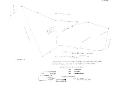 Surveyor-General diagram, 361/1833, September 1833
10N1PP01 119 0.jpg
Cadastre
Surveyor-General diagram index for this parcel
Research notes
[SRC-072] On the Kouka River in the field cornetcy of Traka. Granted on perpetual quitrent 15 APRIL 1841 to Pieter Johannes SwanepoelL (PER-000083), 14,379 morgen, then in the district of Beaufort West - AK: Beaufort West Quits Vol 5 Fol 35. THE EIGHTH FARM NOW DOCUMENTED ON THAT ONE DAY (see STO-0007). Occupied from at least Aug 1837, seven years before the grant. Kouka/Kauka is Khoi for Buffalo River. The thesis gives the farm number as 118 in ch.4 and 119 in ch.5 [TO VERIFY]. Neighbour: Van Aardsfontein No. 109 (PAR-000064).
[3 Aug 2026, SRC-230] ITS 1833 DIAGRAM. Dgm 361/1833 by C. L. Stretch: the LOAN FARM DE RIET KUYL with annexed Government ground, 14 379 morgen, in the TRAKA field cornetcy of the BEAUFORT district, SURVEYED FOR HERMANUS STEIN. Titled Bf.W.Q. 3-35 on 15 APRIL 1841 - the day of STO-0007. Bounded N by Van Aardes Baken, S by Vleige Kraal, E by Muis Kraal, W by Government ground; the Kouka and Scheffers-gate rivers cross it. "4 Morgen arable land" is written across the middle. *** A NUMBER QUESTION, NOT RESOLVED HERE. *** The diagram's title block reads "THE FARM Riet Kuyl No. 118" and this row follows it - but the modern cadastre publishes RIETKUIL as FARM 119, at 12 867,6 ha, and the diagram itself carries a pencilled "Vide farm 119" beside the Government ground on its western side. Frans's filename hint also read 119. So either the farm was renumbered, or the annexed Government ground became 119 while the loan farm kept 118, or 118 and 119 are neighbours. This is the same class of question as Rietfontein/Minnies Kraal and it is not to be settled by picking one. [TO VERIFY]
[3 Aug 2026, SRC-225] A MECHANISM FOR THE 118/119 QUESTION. The verso of the 1886 Klaarstroom diagram shows three portions whose labels were STRUCK OUT AND REPLACED with new numbers decades later - "Lot C" to 178/29, "Ptn. 4" to 178/32, "Ptn. 5" to 178/33. Renumbering on the face of a sheet is evidently ordinary practice in this division, which makes "the farm was renumbered 118 to 119" a live possibility rather than a guess. Still not established.
[5 Aug 2026] FARM NUMBER SETTLED: 119, not 118. The thesis (SRC-072) gave 118 in chapter 4 and 119 in chapter 5, and the row has carried that as [TO VERIFY] since. The Prince Albert cadastre decides it two ways: there is NO FARM 118 in the division at all, and farm 119 is named RIETKUIL and carries eight portions. The extent agrees as well - the 1833 loan farm with its annexed Government ground is 14,379 morgen, about 12,316 ha, against a whole-farm polygon of 12,834 ha, within 4%. The farm is now pinned.
[8 Aug 2026, from SG 361/1833 read for the first time] Stretch surveyed this in September 1833 as 'the Loan Farm DE RIET KUYL including Government ground annexed', 14 379 morgen, in the TRAKA FIELD CORNETCY of the Beaufort district, 'SURVEYED FOR HERMANUS STEIN' [PER-001603]. Four morgen were arable. The Kouka River, the Schepperegate River, Commando Kraal and Eve's Kraal are all drawn and named on the figure. The 15 April 1841 title Bf.W.Q.3-35 grants it to Pieter Johannes SwanepoelL, so the loan place changed hands between the survey and the grant and this project does not know how. [TO VERIFY]
The research behind this page, kept separate from it: dated working notes, open questions, and what is not yet settled.
Open questions
-
Why 15 April 1841? The project's headline question has never been a lead
priority 1 · LEAD-0091
Was the day a batch signature clearing a quitrent conversion backlog, a settlement scheme, or routine administration?
What would settle it The register. If many farms across the district share the date and the underlying entries are spread over years, it is a signing session and the question is answered.
What the record is missing
-
The record stops in 1885 and never resumes
second order · B2 trail-ends
Rietkuil No. 119 (Kouka) was worked as far as 1885-03-26, with Pieter Johannes SwanepoelL (b6c5d7) the last owner on record. 141 years follow with nothing. Who held it after that, and is it still one farm?
What would settle it The current title deed traced backwards, each transfer names the one before it, or the Surveyor-General's subdivision diagrams, which are what usually explain a farm going quiet.
Found by breaks.py reading the model against itself, not written by hand,
each one is a shape of missing record, not a fault in the data.
The whole set is on the
questions page.