Oude Muure
121 on the cadastre · on record 1859–1863 · show on the map
- Farm number
- No. 121
- On the cadastre
- 121, whole farm
- District
- Prince Albert
- Modern surveyed area
- 84.4 ha
Why this farm is here
Ground a written history is set on. 24 km from Klaarstroom.
- story A written history names this ground Rondawel's history: from a widow's mark to today's Marincowitz farm
- story A written history names this ground Kopjes Kraal's story since 1859
- border Shares a boundary with Kopjes Kraal Kopjes Kraal
- border Shares a boundary with Minnies Kraal No. 112 Minnies Kraal No. 112
- …and 2 more, listed in full further down this page.
Stories
- mentions this farm
Rondawel's history: from a widow's mark to today's Marincowitz farm
From a loan-farm widow who signed with a mark to the Marincowitz farm of today: the full documented history of Rondabel No. 124 - the Venter household of 1829, the twelve-farm grant day of 1841, the Oosthuizen-Theron partnership of 1868, the 1910-34 subdivisions, and the two graves by the huis nobody has read.
- mentions this farm
Kopjes Kraal's story since 1859
Crown land surveyed in 1859 at 6,325 morgen and resurveyed four years later at 4,982 - about 1,343 morgen fewer, unexplained. Granted in 1871 to Gerolm Marincowitz of Trieste, whose surname reaches the Karoo from the Adriatic and not from the Netherlands. A stock route across it was ended by a line in a provincial gazette in 1926, and half of what was left became Kromrivier in 1934.
What the record holds, in order
-
November 1859
document
SG diagram 1923/1860
P.A.Q.1-15
- November 1863 document SG diagram 1059/1871
Bordered by, as the diagram names them
- W Kopjes Kraal
- N Minies Kraal
- E Government Land
- S Klip Kraal
On the 1915 divisional map
As the Surveyor-General printed this farm in 1915: the registered holder, the date the title was issued and its quitrent reference, copied off the sheet as written. The whole map, farm by farm
| Farm, as printed | Holder | Title | Quitrent | Note |
|---|---|---|---|---|
| OUDE MUURE | G. Marincowitz | 17 May 1871 | P.A.Q. 1.27 · fol. 1079 |
Also bordered by, as the modern cadastre draws it
Ground that touches this farm on the Surveyor-General's current polygons and that none of the diagrams held here names. Derived from the geometry, not read off a document.
Documents
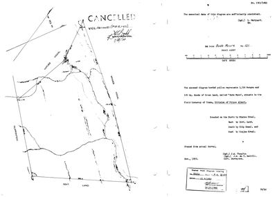 Surveyor-General diagram, 1923/1860, November 1859
SCAN323.TIF
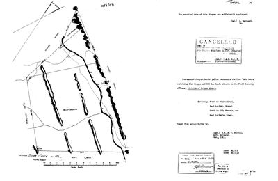 Surveyor-General diagram, 1059/1871, November 1863
10OUNO01.TIF
Cadastre
Surveyor-General diagram index for this parcel
Research notes
Marincowitz farm (Tokkie; later Gerhard Jan Marincowitz on the Prince Albert valuation roll). Eastern neighbour of Kopjes Kraal. [29 Jul 2026] THE 84.7 ha PUZZLE RESOLVED: DOC-0050 carries a CANCELLED stamp - the Remainder of Oude Muure was re-titled under Certificate of Uniform Title 1956-2300 as part of the NEW FARM 112 (vide dgm 8731/1955, 2.3.1956). Only two residual pieces still carry number 121 in the modern cadastre: the 84.7 ha remainder record this row is matched to, and Ptn 2/121 (101.2 ha, the triangle on the Traka - see PAR-000046/Driehoek). The historic 3,245-morgen farm largely lives on inside farm 112; extent_text and sg_area_ha are therefore incomparable BY DESIGN here.
[10 Aug 2026] NOT THE VAN DER MERWE OUDE MUUR. This is farm 121 in the PRINCE ALBERT division. There is a second Oude Muur in the CALVINIA division, PLC-000053, which is where Schalk Willem Burger van der MerweM was born in 1833 and died in 1904 and where his son was resident in 1897. Same name, two districts, two families - Marincowitz here, van der Merwe there. Never conflate them, and note that only THIS one has a cadastral polygon, so a name match will always land here.
The research behind this page, kept separate from it: dated working notes, open questions, and what is not yet settled.
What the record is missing
-
Nobody is on record as ever having held this
third order · B8 never-held
Oude Muure is in the model and drawn on the map, and carries no ownership record of any kind, not a grant, not a transfer, not an occupation.
What would settle it The Surveyor-General's diagram for the farm number names the grantee and the date; the deed reference on it opens the transfer chain.
Found by breaks.py reading the model against itself, not written by hand,
each one is a shape of missing record, not a fault in the data.
The whole set is on the
questions page.