Haggas Nr. 145
· op rekord 1822–1880 · wys op die kaart
- Plaasnommer
- Nr. 145
- Distrik
- Willowmore
- Grootte, soos die kaart dit stel
- 17060 morgen
- Moderne opgemete oppervlakte
- 14216.4 ha
Die historiese grootte en die moderne opgemete oppervlakte is twee aparte metings en word hier nie aangebied asof hulle mekaar bevestig nie. Die eerste is wat 'n landmeter op 'n kaart geskryf het, gewoonlik in morg. Die tweede is wat die moderne kadaster teken.
Waarom hierdie plaas hier is
Cornelis Petrus Janse van Vuuren het hier gewoon, 'n bloedverwant van die Oosthuizen, Marincowitz of Van der Merwe-lyne, 3 treë weg. 29 km van Klaarstroom.
- Cornelis Petrus Janse van Vuuren
- kind van Johannes Marthinus Janse van Vuuren
- ouer van Catharina Adriana Janse Van Vuuren
- ouer van Catharina Maria Oosthuizen
Elke tree is 'n aangetekende afkoms of huwelik in hierdie model, en die kortste een wat die rekord ondersteun; volg die name om dit na te gaan.
- storie 'n Geskrewe geskiedenis noem hierdie grond On 15 April 1841 loan ground becomes property
- storie 'n Geskrewe geskiedenis speel op hierdie grond af The van Vuurens of Wilgemond
- grens Deel 'n grens met Oorlogs Kloof Nr. 172 (Roode Els Bosch and Oorlogs Kloof) Oorlogs Kloof Nr. 172 (Roode Els Bosch and Oorlogs Kloof)
- grens Deel 'n grens met Uitnood Nr. 147 (Loan Farm Uit-Nood) Uitnood Nr. 147 (Loan Farm Uit-Nood)
- …en nog 2, volledig gelys verder af op hierdie bladsy.
Stories
- mentions this farm
Op 15 April 1841 word huurgrond plaaseiendom
Een landmeter meet die Koup twee seisoene lank op. Agt jaar later, op een dag, maak die Kroon 'n dosyn leningsplase titelgrond - en die distrik se kaart lê vir 'n eeu vas.
- set here
Die van Vuurens van Wilgemond
Wilgemond No. 179 was surveyed in 1833 for a "Martinus van Veuren" and granted in 1841 to a "J.M.J. van Vuuren" - two sets of initials on Vrolikheid's western boundary. Four documents later they are a family, and on 22 December 1838 one of them married an Oosthuizen.
Wat die rekord hou, in volgorde
-
1822
ownership
Petrus Johannes van der Westhuizen (Haggas, 1822)
loan farm · occupation · confidence high
-
Augustus 1833
document
SG diagram 357/1833
Bf.W.Q.5-31
-
voor 1833
ownership
P. van der Westhuizen (Haggas, 1833)
loan farm · survey · confidence high
-
4 September 1863
lived here
Cornelis Petrus Janse van Vuuren (18 Mei 1813–4 September 1863)
died there · to 1863-09-04
- 1873–1911 document SG diagram verso 357/1833 (verso)
-
24 Junie 1880
lived here
Maria Magdalena Elisabeth van der Westhuizen (omstreeks 1814–24 Junie 1880)
died there · to 1880-06-24
Begrens deur, soos die kaart hulle noem
- N Oorlogs Kloof and Kloof Plaats
- W Oorlogs Kloof and Kloof Plaats
- S the Loan Farm Uit Nood
- E Vondeling
Op die afdelingskaart van 1915
Soos die Landmeter-generaal hierdie plaas in 1915 gedruk het: die geregistreerde titelhouer, die datum waarop die titel uitgereik is en die erfpagverwysing, net so van die kaart oorgeskryf. Die hele kaart, plaas vir plaas
| Plaas, soos gedruk | Titelhouer | Titel | Erfpag | Aantekening |
|---|---|---|---|---|
| HAGAS | J. M. J. v. Vuuren & another | 24 October 1842 | B.W.Q. 5.31 · fol. 978 | The title date disagrees with DOC-0131, which gives 15 April 1841 for Bf.W.Q.5-31. LEAD-0349. |
Ook begrens deur, soos die moderne kadaster dit teken
Grond wat aan hierdie plaas raak op die Landmeter-generaal se huidige poligone en wat geen kaart wat hier gehou word, noem nie. Afgelei uit die meetkunde, nie van 'n dokument afgelees nie.
- NE Karee Rivier Nr. 143
- NE Spitskop (Karee Rivier Nr. 143 Gdlt 11)
- SE Brakrivier Nr. 148
- W Oorlogs Kloof Nr. 175 (1940 consolidation)
- W De Vlei Nr. 176
Dokumente
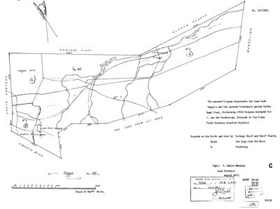 Landmeter-generaal-kaart, 357/1833, Augustus 1833
SCAN914.jpg
 Kaart se keersy, 357/1833 (verso), 1873–1911
SCAN915.jpg
Navorsingsnotas
[31 Jul 2026 inbox] THE LARGEST PARCEL IN THIS MODEL - 17,060 morgen, the loan farm Hagga's plus the annexed Government ground Callabash Kraal, surveyed Aug 1833 by Stretch for P. van der WesthuizenH and titled 15 Apr 1841 on Bf.W.Q.5-31 (DOC-0131). Named on the 1913 Witberg diagram as Witberg's north-eastern neighbour, which is why it is here. WHERE IT IS, established by Frans on the CSG viewer: the WILLOWMORE division, EASTERN CAPE - LPI prefix C0830000, e.g. portion 6/145 is C08300000000014500006 - lying directly EAST of Oorlogs Kloof (172, 175) and Vrolykheid (177), with the PROVINCIAL BOUNDARY running between. That is why farm 145 in our Prince Albert pull is Roode Punt Wes and in our Beaufort West pull is Truters Kuil: this project has never pulled Willowmore. NO GEOMETRY here for that reason, and deliberately not matched to a same-numbered farm in the wrong division - which is exactly the trap 9 warns about. Pulling the Willowmore division would map it and is the obvious next step. In 1833 this was all still 'Beaufort District', which was vast before the later divisions were cut, and the ward was TRAKA - the Willowmore-area Traka, not the Tarka near Tarkastad. CORRECTED SAME DAY: calling this 'the Willowmore-area Traka, not the Tarka near Tarkastad' was half wrong and misleading. TRAKA IS OUR OWN WARD. Vrolikheid (DOC-0027), Rondabel (DOC-0023), Oorlogs Kloof (DOC-0073) and Klipfontein (DOC-0112) each name 'Field Cornetcy of Traka' on their OWN 1833 diagrams, as do Klein Sleutelfontein, Oude Muure and Rhemhoogte 125. The 1935 Vrolykheid portion diagrams show Traka struck through and corrected by hand to KREDOUW, so the ward was simply renamed. Haggas sitting in the modern Willowmore division means the 1830s ward straddled ground that later fell either side of a provincial boundary - it does not make Traka an eastern place. See LEAD-0014, which this answers.
[31 Jul 2026] GEOMETRY WITHDRAWN - the pin was 104 km wrong. Frans, looking at the map: "wtf - haggas should next to oorlogskloof", and he is right: his CSG screenshot gives HAGGAS 145 as LPI C08300000000014500006, registration division C0830000 WILLOWMORE, province EASTERN, sitting against RE/172, 2/172 and RE/175 - which are our Oorlogs Kloof No. 172 and No. 175.
WHAT WENT WRONG, and it is the 9 trap in a new place: FARM NUMBERS REPEAT ACROSS REGISTRATION DIVISIONS. match_cadastre.py had only Prince Albert and Beaufort West polygons to match a "145" against, so it matched a DIFFERENT farm 145 and put Haggas at -33.231944,21.695017. The match report said so at the time - stated extent 17,060 mg = 14,612 ha against a cadastre polygon of 8,845 ha, a ratio of 0.518 - and the warning was printed and not acted on.
NOT REFETCHABLE HERE: Willowmore is EASTERN CAPE and data/fetch_cadastre.py talks to the WESTERN Cape Surveyor-General. Adding WILLOWMORE to that fetch returns zero features, which is the correct answer from the wrong service. Haggas now has NO polygon and is listed as unmapped, per 5: an unresolved place gets no pin, because a wrong pin is worse than a missing one. [TO VERIFY] pull from the Eastern Cape service, or georeference from the CSG viewer, keying on LPI C0830000/145.
[1 Aug 2026] *** WHERE HAGGAS ACTUALLY IS, from a document rather than a cadastre lookup. *** BOTH Oorlogskloof diagrams name Haggis on its boundary: Stretch's 1833 sheet has it on the SOUTH, and Melvill's 1863 resurvey has it on BOTH THE EAST AND THE SOUTH. Oorlogskloof's western boundary is Vrolykheid (PAR-000014). So Haggas sits east and south of Oorlogskloof, which sits east of Vrolikheid - all of it in the Traka field cornetcy, Prince Albert division. THAT IS THE DOCUMENTARY VERSION OF WHAT The geometry stays withdrawn (a wrong pin is worse than none, 5), but the search area is now a documented one: whatever polygon is right must touch Oorlogskloof No. 172 on its east and south.
[1 Aug 2026] *** LOCATED, FROM THE OFFICIAL CSG VIEWER. *** Frans opened it on the parcel itself and the panel reads: Farm Name HAGGAS 145 · 21 Digit Code C08300000000014500006 · Province EASTERN · Major Region WILLOWMORE · Major Code C0830000 · Parcel 145 Portion 6 · Geometry Area 13,966,629.69 m2 (1,396.7 ha) · Parcel Type FP. It is highlighted immediately EAST of RE/175 and 4/145, exactly where Stretch's 1833 sheet and Melvill's 1863 resurvey both put Haggis on Oorlogskloof's boundary. *** AND IT EXPLAINS THE WHOLE CONFUSION: BOTH THINGS WERE TRUE AT ONCE. *** Haggas really IS registered in WILLOWMORE (C0830000, Eastern Cape) - which is why matching it in the Prince Albert division found a different farm 145 and pinned it 104 km away - AND it really IS next to Oorlogskloof, exactly as The registration-division boundary runs right there. The mistake was assuming that Willowmore-registered meant far from Prince Albert. STILL NO GEOMETRY HERE, and the reason has changed: it is no longer that we do not know where it is, it is that we cannot DRAW it. The cadastre fetcher asks the WESTERN CAPE Surveyor-General's service, which does not serve an Eastern Cape division - geo/willowmore_farms.geojson came back with ZERO FEATURES and was written to disk as a 127-byte file, so the failure looked like a success. See LEAD-0053. The LPI above is now recorded and is the thing to fetch with.
*** RESOLVED 1 Aug 2026, AND IT WAS NEVER A SURVEY PROBLEM. *** Haggas is drawn. The polygon is E107C083000000000145000000, 14,216.4 ha, from the NATIONAL cadastre published by the Council for Geoscience, which carries the Eastern Cape and therefore Willowmore. Two independent confirmations: our 1833 sheet says 17,060 morgen = 14,612 ha, a 2.7% agreement; and portion 6 comes back at 1,396.7 ha, the exact figure on Frans's CSG screenshot. Its centroid is 16.1 km EAST of Oorlogs Kloof, which is what THE REAL CAUSE OF THE MONTH-LONG DELAY was not the Eastern Cape at all. fetch_cadastre.py wrote to data/geo/ and match_cadastre.py and build_site.py both read <repo>/geo/. The two directories had drifted, so expanding the pull from 3 divisions to 9 and adding the national Willowmore fetch changed nothing downstream. The symptom to remember: a successful fetch that does not move the match count.
[4 Aug 2026, SRC-249 + SRC-253] TWO PEOPLE DIED ON THIS FARM, and identifying it took two documents read seven months apart. Cornelis Petrus Janse van VuurenL died here on 4 September 1863 - his notice writes the place as "[?Hoeagus]", which was unreadable and matched nothing. His widow MARIA MAGDALENA ELIZABETH VAN DER WESTHUIZEN died here on 24 June 1880, and her notice writes it plainly: "at the farm Hagas District Prince Albert". A third spelling, Haagus, appears on FamilySearch 9ZPK-FYB. One word, three hands. THE STRONGEST PART OF THE IDENTIFICATION IS THE SURNAME: this farm was surveyed in August 1833 for P. VAN DER WESTHUIZEN, and the woman who died on it was a van der Westhuizen. Recorded as RESIDENCE ONLY - the notices say where they lived and died, not what they owned, and no deed here puts either of them on the title. The district discrepancy (Willowmore in the cadastre, Prince Albert on both notices) is recorded unresolved.
[SRC-321, 7 Aug 2026] A FARM CEMETERY IS RECORDED ON THIS GROUND BY eGGSA: 'Gamkaspoortdam, Witpoort 145', Cemetery ID 8155, at -33.255133, 21.680567. Photographs and captions at https://graveswcape.eggsa.org/PRINCE-ALBERT-Rural/Witpoort-145/ - linked, not copied.
[10 Sep 2026] THE eGGSA CEMETERY NOTED ABOVE FROM SRC-321 IS NOT ON THIS GROUND. 'Gamkaspoortdam, Witpoort 145' (CEM-471) sits at -33.255133, 21.680567, 109 km west of Haggas, in eGGSA's Prince Albert rural collection: it is farm 145 of the PRINCE ALBERT registration division, the same number on a different farm - the trap this row already records once. CEM-471 was never linked to this parcel (its par_id is empty), so only this note carried the error.
Werknotas, hier gewys omdat dit 'n private navorsingsbou is.
Die werksnotas op hierdie werf word in Engels gehou en word nie vertaal nie. Hulle verander met elke navorsingsessie, en 'n vertaling sou uit pas raak met die oorspronklike. Alles anders - die stories, die getranskribeerde dokumente en die koppelvlak - is in Afrikaans.
Oop vrae
-
Two Prince Albert parcels numbered 172, and a Haggas the cadastre extract cannot see
prioriteit 2 · LEAD-0053
What is the 1,420 ha parcel also numbered 172 at (-33.3165, 22.8003), and where exactly is Haggas No. 145?
Wat dit sou uitmaak A cadastre feature named Haggas with a PRCL_KEY, touching Oorlogs Kloof on its east or south.
-
Four farms where the 1915 divisional map and this record give a different title date
prioriteit 3 · LEAD-0349
The 1915 divisional map prints a title date and quitrent number on every farm. On four farms this project already holds, it disagrees with the record: which is right? (1) HAGAS No. 145: the map prints B.W.Q. 5.31 to J.M.J. v. Vuuren and another, dated 24 October 1842; DOC-0131 carries Bf.W.Q.5-31 with a title date of 15 April 1841. (2) WILGER FONTEIN: the map prints 17th May 1878 against P.A.Q. 2.11; DOC-0352 and OWN-000119 read the same title as 17 May 1875. (3) WILGEMOND: the map prints 16 April 1841 against B.W.Q. 5.9; OWN-000075 has 15 April 1841, the grant day. (4) KLIPGAT: the map prints an amended title to the estate of the late L.D.F. v. Zyl as 9.9.191[?1]; OWN-000088 and DOC-0158 have 24 September 1911, P.A.Q. 6-7.
Wat dit sou uitmaak The date written on the quitrent title itself, which both the map and the diagrams copied.
Wat die rekord kortkom
-
The record stops in 1833 and never resumes
second order · B2 trail-ends
Haggas Nr. 145 was worked as far as ../1833, with P. van der WesthuizenH (Haggas, 1833) the last owner on record. 193 years follow with nothing. Who held it after that, and is it still one farm?
What would settle it The current title deed traced backwards, each transfer names the one before it, or the Surveyor-General's subdivision diagrams, which are what usually explain a farm going quiet.
Found by breaks.py reading the model against itself, not written by hand,
each one is a shape of missing record, not a fault in the data.
The whole set is on the
questions page.