Brakrivier Nr. 148
· op rekord 1928 · wys op die kaart
- Plaasnommer
- Nr. 148
- Distrik
- Willowmore
- Moderne opgemete oppervlakte
- 1707.3 ha
Waarom hierdie plaas hier is
Hier omdat 'n oop vraag in hierdie rekord daaroor gaan; wie hierdie grond gehou het, is nog nie vasgestel nie. 31 km van Klaarstroom.
- dokument 'n Dokument in die versameling beskryf hierdie grond DOC-0313
- leidraad 'n Oop vraag in hierdie rekord gaan oor hierdie grond Which J. A. Oosthuizen held land in the Field Cornetcy of Traka in 1891?
Wat die rekord hou, in volgorde
- November 1928 document SG diagram A 240/1929
Ook begrens deur, soos die moderne kadaster dit teken
Grond wat aan hierdie plaas raak op die Landmeter-generaal se huidige poligone en wat geen kaart wat hier gehou word, noem nie. Afgelei uit die meetkunde, nie van 'n dokument afgelees nie.
Dokumente
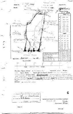 Landmeter-generaal-kaart, A 240/1929, November 1928
10TKTG01.jpg
Navorsingsnotas
SG diagram A 240/1929 (DOC-0313), approved 11 Feb 1929, surveyed Nov 1928: 2001 morgen 63 sq roods, FIELD CORNETCY OF TRAKA, Willowmore division. Extent checks against the cadastre at 1714 ha read off the diagram against 1707 ha drawn, within half a percent.
*** ITS OWN DESCRIPTION NAMES AN OOSTHUIZEN: the farm comprises 884 morgen 214 sq rds 'portion of the land transferred to J. A. OOSTHUIZEN on the 29th of May 1891', plus 1116 morgen 449 sq rds of UITNOOD (PAR-000100, No. 147) held under amended title to S. Schoeman, 6 Dec 1918. *** WHICH J. A. Oosthuizen is NOT established - this model holds a dozen who could be alive in 1891 and 9 forbids matching on a name. See the lead.
Neighbours on the face, several already here: Uitnood, Portion of HAGAS (PAR-000094, No. 145), road of No. 23 SPITSKOP (cf. PAR-000102), Samen Suiping, Geruste Leven B and Annexe, Voor Zeeridouw A and B. Transferred 12 Mar 1925 to E. E. Koen.
Werknotas, hier gewys omdat dit 'n private navorsingsbou is.
Die werksnotas op hierdie werf word in Engels gehou en word nie vertaal nie. Hulle verander met elke navorsingsessie, en 'n vertaling sou uit pas raak met die oorspronklike. Alles anders - die stories, die getranskribeerde dokumente en die koppelvlak - is in Afrikaans.
Oop vrae
-
Which J. A. Oosthuizen held land in the Field Cornetcy of Traka in 1891?
prioriteit 1 · LEAD-0239
The 1929 diagram of Brakrivier No. 148 (SRC-492) describes part of the farm as 884 morgen 214 sq rds 'portion of the land transferred to J. A. OOSTHUIZEN on the 29th of May 1891'. Who was he?
Wat dit sou uitmaak The 29 May 1891 transfer deed, which gives his full names. Failing that, an estate file or death notice for one of the four grandsons that names ground in the Willowmore division or the Field Cornetcy of Traka - all four have dates of death, so all four have a death notice to find.
Wat die rekord kortkom
-
Nobody is on record as ever having held this
third order · B8 never-held
Brakrivier Nr. 148 is in the model and drawn on the map, and carries no ownership record of any kind, not a grant, not a transfer, not an occupation.
What would settle it The Surveyor-General's diagram for the farm number names the grantee and the date; the deed reference on it opens the transfer chain.
Found by breaks.py reading the model against itself, not written by hand,
each one is a shape of missing record, not a fault in the data.
The whole set is on the
questions page.