Uitnood Nr. 147 (Loan Farm Uit-Nood)
· op rekord 1833 · wys op die kaart
- Plaasnommer
- Nr. 147
- Distrik
- Willowmore
- Grootte, soos die kaart dit stel
- 6,376 morgen including the annexed Government ground
- Moderne opgemete oppervlakte
- 4725.2 ha
Die historiese grootte en die moderne opgemete oppervlakte is twee aparte metings en word hier nie aangebied asof hulle mekaar bevestig nie. Die eerste is wat 'n landmeter op 'n kaart geskryf het, gewoonlik in morg. Die tweede is wat die moderne kadaster teken.
Waarom hierdie plaas hier is
Petrus van Veuren Senior het dit gehou, en geen verwantskap met die Oosthuizen, Marincowitz of Van der Merwe-lyne is aangeteken nie. Hierdie grond het deur die grond ingekom, nie deur die familie nie. 36 km van Klaarstroom.
- grens Deel 'n grens met Haggas Nr. 145 Haggas Nr. 145
- grens Deel 'n grens met Vondeling Nr. 139 Vondeling Nr. 139
- dokument 'n Dokument in die versameling beskryf hierdie grond DOC-0155
- dokument 'n Dokument in die versameling beskryf hierdie grond DOC-0156
- …en nog 2, volledig gelys verder af op hierdie bladsy.
Wat die rekord hou, in volgorde
-
Augustus 1833
document
SG diagram B 358/1833
Bf.W.Q.5-32
- Augustus 1833 document SG diagram B 358/1833 (reverse)
-
omstreeks 1833
ownership
Petrus van Veuren Senior
quitrent · grant · confidence high
Begrens deur, soos die kaart hulle noem
- N the Loan Farm Haggis
- S Zwarte Berg
- E the Vondeling
- W Haggis
Op die afdelingskaart van 1915
Soos die Landmeter-generaal hierdie plaas in 1915 gedruk het: die geregistreerde titelhouer, die datum waarop die titel uitgereik is en die erfpagverwysing, net so van die kaart oorgeskryf. Die hele kaart, plaas vir plaas
| Plaas, soos gedruk | Titelhouer | Titel | Erfpag | Aantekening |
|---|---|---|---|---|
| UITNOOD | D. L. Harmse | 15 April 1841 | B.W.Q. 5.32 · fol. 979 |
Op hierdie grond begrawe
- Uitnood 147-plaasbegraafplaas, Swartberge 2 grafte opgeteken, 2 in hierdie projek geïdentifiseer
Die begrafnisse verskyn ook op hierdie plaas se tydlyn hierbo, elkeen op sy eie datum.
Ook begrens deur, soos die moderne kadaster dit teken
Grond wat aan hierdie plaas raak op die Landmeter-generaal se huidige poligone en wat geen kaart wat hier gehou word, noem nie. Afgelei uit die meetkunde, nie van 'n dokument afgelees nie.
Dokumente
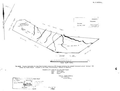 Landmeter-generaal-kaart, B 358/1833, Augustus 1833
SCAN923.jpg
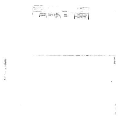 Landmeter-generaal-kaart, B 358/1833 (reverse), Augustus 1833
SCAN924.jpg
Navorsingsnotas
[1 Aug 2026 inbox] Loan farm, Traka field cornetcy, District of Beaufort. SG Dgm B 358/1833 (DOC-0155), surveyed by C. LENNOX STRETCH, AUGUST 1833, for PETRUS VAN VEUREN SENIOR. Title Bf.W.Q.5-32 dated 15 APRIL 1841, re-stamped 20.9.1963. Bounded N by the Loan Farm Haggis, S by the Zwarte Berg, E by the Vondeling, W by Haggis. The sheet names 'Geruste Leven B', 'Cheridauw voor Zeeridouw B' and an arable of 10 morgen. TWO CONNECTIONS THIS MAKES. (1) THE 15 APRIL 1841 GRANT DAY: Uitnood's title is Bf.W.Q.5-32, on the same day as Oorlogs Kloof's Bf.W.Q.5-30, Haggas's Bf.W.Q.5-31, the Hitge title B.W.Q.5-18 and Reim Hoogte's B.F.W.Q.5-10. The numbers are now consecutive across four farms we hold, which strengthens the mass-grant reading in S007 rather than the coincidence reading. (2) THE VAN VEURENS: Oorlogs Kloof No. 172 (PAR-000066, DOC-0073) was surveyed the same month by the same surveyor for LUCAS VAN VEUREN, recorded on that form as 'P. Zoon'. Petrus van Veuren SeniorH holding the adjoining Uitnood reads as the P. that 'P. Zoon' names, so father and son took up neighbouring ground in the Traka in August 1833. That is an inference from two diagrams, not a stated relationship, and it is [TO VERIFY] against a death notice or an estate paper. See LEAD-0054. PORTIONS, from the reverse (DOC-0156): Geruste Leven B = Portion 147/1, 1,885 morgen, Dgm 666/1910, registered 1910-135-8686; Voor Zeeridouw B = Portion 147/3, 3,190 morgen, Dgm 345/1917, registered 1921-129-7798 (an earlier 27.9.1918-6810 entry is struck through). 1918 endorsements name Schoeman (6 Dec 1918) and a 'remainder Stephanus'. NO GEOMETRY: not yet matched to the cadastre. [1 Aug 2026]
[1 Aug 2026] REGISTRATION DIVISION CORRECTED to Willowmore (PLC-000037). The 1833 diagram says "Traka Field Cornetcy, District of Beaufort", and the national cadastre puts UITNOOD 147 in C0830000 WILLOWMORE, Eastern Cape. Exactly the Haggas situation: the 1830s Beaufort District was vast and was later cut, and the provincial boundary now runs through this ward. The ward is still Traka, which is ours.
[15 Aug 2026] THE FARM CEMETERY ON IT HOLDS AN OOSTHUIZEN CHILD, AND HE IS HERE THROUGH HIS MOTHER. CEM-059 carries two read stones. One is GRV-1450, Okkert Jacobus OosthuizenL, died 9 October 1842 aged two years and ten months - THE EARLIEST DATED OOSTHUIZEN BURIAL IN THIS PROJECT, sixteen years before Ockert Almero and Adriana Cecilia's own deaths. His mother was Catharina Adriana Janse van Vuuren [PER-000605], which is why an Oosthuizen lies on ground surveyed for Petrus van Veuren SeniorH. The other stone is a Hitge by marriage. Whether the boy's mother is kin to this farm's grantee is NOT established - see LEAD-0197.
Werknotas, hier gewys omdat dit 'n private navorsingsbou is.
Die werksnotas op hierdie werf word in Engels gehou en word nie vertaal nie. Hulle verander met elke navorsingsessie, en 'n vertaling sou uit pas raak met die oorspronklike. Alles anders - die stories, die getranskribeerde dokumente en die koppelvlak - is in Afrikaans.
Oop vrae
-
Which J. A. Oosthuizen held land in the Field Cornetcy of Traka in 1891?
prioriteit 1 · LEAD-0239
The 1929 diagram of Brakrivier No. 148 (SRC-492) describes part of the farm as 884 morgen 214 sq rds 'portion of the land transferred to J. A. OOSTHUIZEN on the 29th of May 1891'. Who was he?
Wat dit sou uitmaak The 29 May 1891 transfer deed, which gives his full names. Failing that, an estate file or death notice for one of the four grandsons that names ground in the Willowmore division or the Field Cornetcy of Traka - all four have dates of death, so all four have a death notice to find.
-
Petrus van Veuren Senior and Lucas van Veuren "P. Zoon": father and son on adjoining ground?
prioriteit 2 · LEAD-0054
Was Lucas van VeurenM of Oorlogs Kloof No. 172 the son of Petrus van Veuren SeniorH of Uitnood No. 147?
Wat dit sou uitmaak A death notice or estate account naming Lucas as a son of Petrus, or a baptism entry giving Lucas a father Petrus. Either would turn an initial into a relationship.
-
Six parcels whose surveyed extent is far from their polygon with no reason recorded
prioriteit 2 · LEAD-0093
For each, is the extent mistyped, or did ground leave the farm without a note?
Wat dit sou uitmaak The deduction table. It lists portion, name, extent, diagram and deed on one line.
-
Is the Uitnood grantee kin to the van Vuuren mother buried beside him, and are the three August 1833 van Veurens one family?
prioriteit 2 · LEAD-0197
C. Lennox Stretch surveyed three farms for three van Veurens in AUGUST 1833: Uitnood No. 147 for PETRUS VAN VEUREN SENIOR, Oorlogs Kloof No. 172 for LUCAS VAN VEUREN recorded as "P. Zoon", and Wilgamount for a MARTINUS VAN VEUREN. Are they one family, and is any of them kin to CATHARINA ADRIANA JANSE VAN VUUREN [PER-000605], whose two-year-old son lies in the Uitnood farm cemetery in 1842?
Wat dit sou uitmaak One document naming a Petrus van Veuren and a Johannes Marthinus Janse van VuurenL in the same family - a death notice, an estate account, or a baptism where one witnesses for the other. Or a transfer of Uitnood to an heir this model can already name.
Wat die rekord kortkom
-
The record stops in 1833 and never resumes
second order · B2 trail-ends
Uitnood Nr. 147 (Loan Farm Uit-Nood) was worked as far as 1833~, with Petrus van Veuren SeniorH the last owner on record. 193 years follow with nothing. Who held it after that, and is it still one farm?
What would settle it The current title deed traced backwards, each transfer names the one before it, or the Surveyor-General's subdivision diagrams, which are what usually explain a farm going quiet.
Found by breaks.py reading the model against itself, not written by hand,
each one is a shape of missing record, not a fault in the data.
The whole set is on the
questions page.