Part of Varsche Fontein
Plaat Fontein (Varsche Fontein No. 27 Ptn 3)
· on record 1923 · show on the map
The farm's own history, the grant, the original survey, sits on that page.
- Farm number
- No. 27
- Portion
- 3
- Also recorded as
- Plaat Fonteinthis project, from the diagramsPlatfonteinSRC-436, 2023 valuation roll
- District
- Prince Albert
- Extent, as the diagram states it
- 2100 morgen 25 sq roods
- Modern surveyed area
- 1786.2 ha
The historic extent and the modern surveyed area are two separate measurements and are not presented here as confirming each other. The first is what a surveyor wrote on a diagram, usually in morgen. The second is what the modern cadastre draws.
Why this farm is here
J.W. van Zyl (?) held it, and no kinship to the Oosthuizen, Marincowitz or Van der Merwe lines is recorded, this ground entered through the land, not the family. 65 km from Klaarstroom.
- parcel Cut out of Varsche Fontein
- border Shares a boundary with Lot A (Varsche Fontein No. 27 Ptn 1) Lot A (Varsche Fontein No. 27 Ptn 1)
- border Shares a boundary with Groot Rivier (Varsche Fontein No. 27 Ptn 2) Groot Rivier (Varsche Fontein No. 27 Ptn 2)
- border Shares a boundary with Varsche Fontein No. 27 Remainder Varsche Fontein No. 27 Remainder
- …and 2 more, listed in full further down this page.
Before this ground was cut out
This is the history of Varsche Fontein, the farm this ground was part of until 1923. It is shown here because this ground was that farm, and separately from what follows because before the cut the record says the farm's name and not which part of it. Not everything below necessarily happened on this piece.
- 1834 document SG diagram 353/1834 Bf.W.Q.6-23
- 1841-04-15 ownership Charl du Toit (1797-09-17–) Perpetual Quitrent · grant · confidence high
- 1848 grave B. Storm Varsche Fontein farm cemetery, B. STORM 1848, scratched on a slate slab set upright in a stone kerb. Nothing else is cut on the stone.
- 1849 grave M. Storm Varsche Fontein farm cemetery, M STORM / 1849, read across two fragments of one broken slab: 'M S' and '18' on the left piece, 'TORM' and '49' on the right. Deeply and neatly cut, in plain capitals, with no other text.
- 1874-06 grave G.F. Beukes Varsche Fontein - the single grave in the veld, 1874 / G F / BEU / KES / Juny, and below it what appears to be 15. Cut by hand into a thin sandstone slab, the letters shallow and irregular and the surname broken across three lines because the stone is narrow. Frans's reading; the 15 is the least certain part.
- 1897-04 document SG diagram No.2 1903 (CL-7) PA folio 1048
- 1897-04 document SG diagram verso 2/1903 (verso)
- 1902-06 grave Maria Elizabeth Freysen Varsche Fontein farm cemetery, MARIHA ELIESABET FREYSEN, GEBOR 6 OCTO[BER] 1901, OVERLEID [4?] JUNY 1902. Above the panel, a rayed sun or star inside an arch.
- 1903 ownership J.R.G. Luttig (1824~–1914-02-04) amended-title · confidence high
- 1907-08-03 grave M.J. Beukes, or a child of M.J. Beukes Varsche Fontein farm cemetery, [Ter ge]dachtenis aan / [illegible word] M·J·BEUKES / O[verlede] 3. 8. 1907. Cut by hand into a sandstone slab in a mixed script - the first line in cursive, the name in capitals - with a ruled border and an incised cross or star above. The word before the initials is not legible and it is the word that decides who is buried here.
- 1913 boundary subdivision: becomes Lot A (Varsche Fontein No. 27 Ptn 1)
- 1913-03 grave Jacobus Johannes Beukes (infant) Varsche Fontein farm cemetery, JACOBES : JOHANES / BEUKES / GEB 26 MAAIE 1912 / [O]VER[L] 10 MAART 191[3] / IS HET WEL MET / 'T KIND / HET IS ALLES WEL.
- 1914-10-14 grave Gerhardus Fransoiys Beukes Varsche Fontein farm cemetery, GERHARDUS FRANSOIYS BEUKES, GEB. 30STEN JUNIE 1838, OVERL. 14 DEN OCTOBER 1914
- 1922 boundary subdivision: becomes Groot Rivier (Varsche Fontein No. 27 Ptn 2)
- 1922-01 grave Aletta Sophia Jacoba Opperman, born Beukes Varsche Fontein farm cemetery, A BROKEN FRAGMENT AND MOSTLY UNREADABLE. Letters scratched into cement before it set, in at least four lines. What can be read with any confidence: 'TER' on the top line, and 'BEU' at the end of the bottom line. Scattered capitals between them include what may be A, G, J, C, E, R and N, in no order that can be trusted. NOTHING ELSE IS TRANSCRIBED.
- 1923 boundary subdivision: becomes Plaat Fontein (Varsche Fontein No. 27 Ptn 3)
What the record holds, in order
- 1923 boundary change subdivision: from Varsche Fontein
-
January 1923
document
SG diagram A191/1923
2267/1923
- 23 January 1923 document surveyor report A191/1923
-
27 March 1923
ownership
J.W. van Zyl (?)
transfer · confidence medium
Bordered by, as the diagram names them
- NE Klein Knoffels Fontein
- SE Varsche Fontein Remainder
- S Groot Rivier
- NW Lot A
- NW Jan Willems Fontein
Also bordered by, as the modern cadastre draws it
Ground that touches this farm on the Surveyor-General's current polygons and that none of the diagrams held here names. Derived from the geometry, not read off a document.
Documents
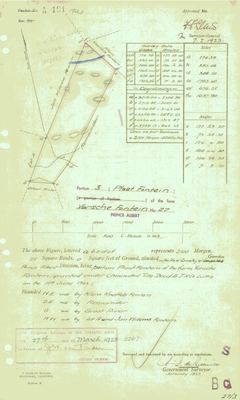 Surveyor-General diagram, A191/1923, January 1923
10777802 (1).PDF
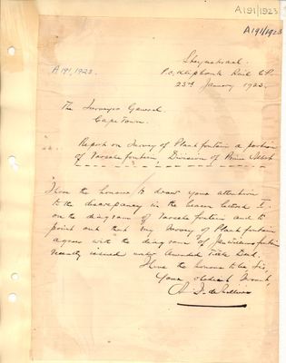 Surveyor's report, A191/1923, 23 January 1923
10777808 (1).PDF
Cadastre
Surveyor-General diagram index for this parcel
Surveyor-General diagram index for the whole farm, where the original survey of this ground sits.
Research notes
SG Dgm A191/1923; deed 1923-43-2267
[13 Aug 2026] Renamed to the one form this model uses for every portion - the portion's own name, then the parent farm, its number and the portion in brackets - so that a name is legible in a list, a search result and a map popup without the reader having to know which farm number is which. It read "Plaat Fontein (Varsche Fontein Ptn 3)" before. Nothing about the ground changed.
The research behind this page, kept separate from it: dated working notes, open questions, and what is not yet settled.
Open questions
-
Morgen or hectares? extent_text may be inconsistent
priority 1 · LEAD-0007
Are the figures in parcels.extent_text really morgen, or are some of them hectares mislabelled as morgen?
What would settle it Reading the figure and its unit directly off the diagrams for the nine flagged parcels.
-
Substituting Diagram 2014/1921 cancelled the 1834 grant of Jan Willems Fontein, and the farm grew by a quarter
priority 2 · LEAD-0146
S.G. Dgm 354/1834 gives Jan Willems Fontein No. 32 as 7,059 morgen, about 6,046 ha. The modern whole-farm polygon is 7,703.6 ha. The 1834 sheet is stamped CANCELLED, vide Subst. Dgm 2014/1921, D/T 1922-50-2887. What did the 1921 resurvey do, and where did the extra ground come from?
What would settle it Diagram 2014/1921, which will state the resurveyed extent and name what was taken in.
What the record is missing
-
The record stops in 1923 and never resumes
second order · B2 trail-ends
Plaat Fontein (Varsche Fontein No. 27 Ptn 3) was worked as far as 1923-03-27, with J.W. van ZylH (?) the last owner on record. 103 years follow with nothing. Who held it after that, and is it still one farm?
What would settle it The current title deed traced backwards, each transfer names the one before it, or the Surveyor-General's subdivision diagrams, which are what usually explain a farm going quiet.
-
“Klein Knoffels Fontein” is named as a neighbour 3 times and we hold no parcel for it
second order · B3 unheld-farm
3 separate surveys in this model put Klein Knoffels Fontein on the boundary of ground we do hold (PAR-000002, PAR-000017). It has no parcel of its own here, so nothing is known about who held it or when, while it borders farms at the centre of the project.
What would settle it The Surveyor-General's farm index for the registration division will give it a farm number and a diagram; the cadastre pull in `fetch_cadastre.py` then places it on the map.
Found by breaks.py reading the model against itself, not written by hand,
each one is a shape of missing record, not a fault in the data.
The whole set is on the
questions page.