Deel van Varsche Fontein
Welbedacht (Varsche Fontein Nr. 27 Gdlt 4)
· op rekord 1924–2013 · wys op die kaart
Die plaas se eie geskiedenis - die toekenning, die oorspronklike opmeting - sit op daardie bladsy.
- Plaasnommer
- Nr. 27
- Gedeelte
- 4
- Ook aangeteken as
- WelbedachtDIAGRAM, and the name this project has usedunnamedSRC-436, the 2023 valuation roll leaves this portion without a name
- Distrik
- Prince Albert
- Grootte, soos die kaart dit stel
- 2536 morgen 291 sq roods
- Moderne opgemete oppervlakte
- 2184.2 ha
Die historiese grootte en die moderne opgemete oppervlakte is twee aparte metings en word hier nie aangebied asof hulle mekaar bevestig nie. Die eerste is wat 'n landmeter op 'n kaart geskryf het, gewoonlik in morg. Die tweede is wat die moderne kadaster teken.
Waarom hierdie plaas hier is
Maria Magritha van Rensburg het dit gehou, 'n bloedverwant van die Oosthuizen, Marincowitz of Van der Merwe-lyne, 1 tree weg. 58 km van Klaarstroom.
Elke tree is 'n aangetekende afkoms of huwelik in hierdie model, en die kortste een wat die rekord ondersteun; volg die name om dit na te gaan.
- perseel Uitgesny uit Varsche Fontein
- perseel Related to Varsche Fontein Nr. 27 Restant
- grens Deel 'n grens met Spreeuw Fontein & Toornits Kraal (Spreeufontein Nr. 26) Spreeuw Fontein & Toornits Kraal (Spreeufontein Nr. 26)
- grens Deel 'n grens met Groot Rivier (Varsche Fontein Nr. 27 Gdlt 2) Groot Rivier (Varsche Fontein Nr. 27 Gdlt 2)
- …en nog 2, volledig gelys verder af op hierdie bladsy.
Wat die rekord hou, in volgorde
-
November 1924
document
SG diagram A4049/1924
2680/1925
- 17 November 1924 document surveyor report A4049/1924
- 1925 boundary change subdivision: from Varsche Fontein
-
24 Maart 1925
ownership
C.M. Fourie
transfer · confidence high
-
1973 to 1997
ownership
Maria Magritha van Rensburg (28 Oktober 1928–3 April 2019)
purchase · confidence high
- 1997/ boundary change held_together: from Varsche Fontein Nr. 27 Restant
-
6 November 1997
ownership
a family trust
trust · transfer · confidence high
-
27 September 2013
document
deeds report
T107406/1997
Begrens deur, soos die kaart hulle noem
- W Groot Rivier
- E Spreeuw Fontein
- N Varsche Fontein Remainder
- SW Blaauw Krantz
- S Klein Fontein
- E Spreeuw Fontein
Ook begrens deur, soos die moderne kadaster dit teken
Grond wat aan hierdie plaas raak op die Landmeter-generaal se huidige poligone en wat geen kaart wat hier gehou word, noem nie. Afgelei uit die meetkunde, nie van 'n dokument afgelees nie.
- E Lot A (Spreeufontein Nr. 26 Gdlt 3)
- SE Bokfontein Nr. 94 (formerly Waterfall)
- W Bloukrans Nr. 31
- NW Varsche Fontein
Dokumente
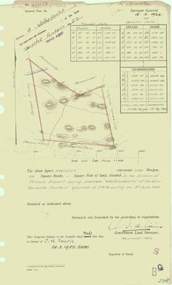 Landmeter-generaal-kaart, A4049/1924, November 1924
10774364 (1).PDF
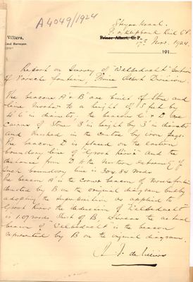 Landmeter se verslag, A4049/1924, 17 November 1924
10774365 (1).PDF
170857414.pdf
Kadaster
Die Landmeter-generaal se kaartindeks vir hierdie perseel
Die Landmeter-generaal se kaartindeks vir die hele plaas, waar die oorspronklike opmeting van hierdie grond lê.
Navorsingsnotas
SG Dgm A4049/1924; deed 1925-60-2680. Sold to C.M. FourieH in 1925 and BACK in the family by 1973 - held with the Remainder by a family trustH under one title. Deeds extent 2172.5806 ha matches the diagram exactly.
[FAMILY, 6 Aug 2026] ONE FARM, TWO PARCELS. [FAMILY] Varschefontein 4 and restant go together... for all practical purposes its one farm, though 2 parcels. The Remainder (PAR-000019) and Welbedacht, Portion 4 (PAR-000018), have been held under ONE TITLE since 1997 and are worked as a single unit. The cadastre keeps them apart because title and working reality are different things - the same distinction 5 makes for vernacular names. Anything that counts farms here should count these two as one, and anything that maps them should show them together.
[13 Aug 2026] Renamed to the one form this model uses for every portion - the portion's own name, then the parent farm, its number and the portion in brackets - so that a name is legible in a list, a search result and a map popup without the reader having to know which farm number is which. It read "Welbedacht (Varsche Fontein Ptn 4)" before. Nothing about the ground changed.
[13 Aug 2026, FAMILY] Frans: on Varschefontein "two portions are considered one unit - so Varschefontein today is the portions 1 and 4, and the name Welbedacht is not used." THE DOCUMENTED POSITION IS KEPT, at his instruction, and the modern working arrangement is recorded beside it: Portions 1 and 4 are one farm in practice, known as Varschefontein, and Welbedacht is not in current use. Two things corroborate it independently - the 2023 valuation roll rates this portion at 2172.5810 ha and leaves it UNNAMED, matching this row's extent to four decimal places; and the roll has no Portion 1 row at all.
Werknotas, hier gewys omdat dit 'n private navorsingsbou is.
Die werksnotas op hierdie werf word in Engels gehou en word nie vertaal nie. Hulle verander met elke navorsingsessie, en 'n vertaling sou uit pas raak met die oorspronklike. Alles anders - die stories, die getranskribeerde dokumente en die koppelvlak - is in Afrikaans.
Wat die rekord kortkom
-
48 years, and the ground changes hands to nobody we can follow
second order · B1 succession
On Welbedacht (Varsche Fontein Nr. 27 Gdlt 4), C.M. FourieH is the last owner recorded from 1925-03-24, and the next entry is Maria Magritha van RensburgH from 1973, 48 years later, with no person in common. DOC-0053 records the later arrival but not the 48 years before it.
What would settle it The Deeds Office transfer register for this farm between 1925 and 1973. A transfer names its predecessor in title, so one deed closes the whole gap.
-
24 years, and the ground changes hands to nobody we can follow
second order · B1 succession
On Welbedacht (Varsche Fontein Nr. 27 Gdlt 4), Maria Magritha van RensburgH is the last owner recorded from 1973, and the next entry is a family trustH from 1997-11-06, 24 years later, with no person in common. DOC-0053 records the later arrival but not the 24 years before it.
What would settle it The Deeds Office transfer register for this farm between 1973 and 1997. A transfer names its predecessor in title, so one deed closes the whole gap.
-
“Klein Fontein” is named as a neighbour 4 times and we hold no parcel for it
second order · B3 unheld-farm
4 separate surveys in this model put Klein Fontein on the boundary of ground we do hold (PAR-000002, PAR-000018, PAR-000020). It has no parcel of its own here, so nothing is known about who held it or when, while it borders farms at the centre of the project.
What would settle it The Surveyor-General's farm index for the registration division will give it a farm number and a diagram; the cadastre pull in `fetch_cadastre.py` then places it on the map.
Found by breaks.py reading the model against itself, not written by hand,
each one is a shape of missing record, not a fault in the data.
The whole set is on the
questions page.