Bokfontein Nr. 94 (formerly Waterfall)
94 op die kadaster · op rekord 1839–1921 · wys op die kaart
- Plaasnommer
- Nr. 94
- Op die kadaster
- 94, heel plaasgeregistreer as BOKFONTEIN
- Distrik
- Prince Albert
- Grootte, soos die kaart dit stel
- 11 583 morgen 300 roods
- Moderne opgemete oppervlakte
- 8138.6 ha
Die historiese grootte en die moderne opgemete oppervlakte is twee aparte metings en word hier nie aangebied asof hulle mekaar bevestig nie. Die eerste is wat 'n landmeter op 'n kaart geskryf het, gewoonlik in morg. Die tweede is wat die moderne kadaster teken.
Waarom hierdie plaas hier is
'n Begraafplaas staan op hierdie plaas, en dit is hoe dit in hierdie rekord beland. 48 km van Klaarstroom.
- grens Deel 'n grens met Spreeuw Fontein & Toornits Kraal (Spreeufontein Nr. 26) Spreeuw Fontein & Toornits Kraal (Spreeufontein Nr. 26)
- grens Deel 'n grens met Abrahams Kraal Abrahams Kraal
- grens Deel 'n grens met Plaas 215 Plaas 215
- grens Deel 'n grens met Plaas 241 Plaas 241
- …en nog 2, volledig gelys verder af op hierdie bladsy.
Wat die rekord hou, in volgorde
-
1839
document
SG diagram 522/1839
Bf.W.Q. 5-25
-
1887
burial
Gesina Maria le Grange
Groot Waterval farm cemetery
-
1889
burial
Willem Nicholas Hendrik Niehaus
Kleinfontein farm cemetery, Bokfontein 94
-
1921
burial
Dirk Johannes du Plessis
Kleinfontein farm cemetery, Bokfontein 94
- undated document SG diagram verso 522/1839 (verso)
Begrens deur, soos die kaart hulle noem
- N Spreuw Fontein
- S Government ground
- E Government ground
- W Abrahams Kraal
Op hierdie grond begrawe
- Kleinfontein-plaasbegraafplaas, Bokfontein 94 2 grafte opgeteken
- Groot Waterval-plaasbegraafplaas 1 grafte opgeteken
Die begrafnisse verskyn ook op hierdie plaas se tydlyn hierbo, elkeen op sy eie datum.
Ook begrens deur, soos die moderne kadaster dit teken
Grond wat aan hierdie plaas raak op die Landmeter-generaal se huidige poligone en wat geen kaart wat hier gehou word, noem nie. Afgelei uit die meetkunde, nie van 'n dokument afgelees nie.
- N Lot A (Spreeufontein Nr. 26 Gdlt 3)
- N Lot B (Spreeufontein Nr. 26 Gdlt 4)
- NE Vredendal (Spreeufontein Nr. 26 Gdlt 1)
- E Plaas 215
- SE Plaas 241
- SE Ganna Vlakte Nr. 100
- S Ganna Vlakte Nr. 98
- S Ganna Vlakte Nr. 99
- SW Rietfontein Nr. 95
- SW Ganna Vlakte Annex Nr. 97
- W Bloukrans Nr. 31
- W Klipfontein Nr. 93
- NW Varsche Fontein
- NW Welbedacht (Varsche Fontein Nr. 27 Gdlt 4)
Dokumente
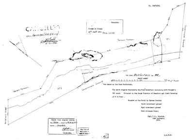 Landmeter-generaal-kaart, 522/1839, 1839
SCAN459 94 0.jpg
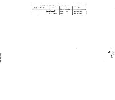 Kaart se keersy, 522/1839 (verso)
SCAN460 94 0.jpg
Kadaster
Die Landmeter-generaal se kaartindeks vir hierdie perseel
Navorsingsnotas
[4 Aug 2026, SRC-256] A FARM THAT CHANGED ITS NAME. The 1839 diagram is headed "THE FARM BOKFONTEIN No 94, PRINCE ALBERT" with a note added later - "Now known as the farm Bokfontein" - but the body of the sheet calls it something else entirely: "The above diagram Represents the FARM WATERFALL Containing 11583 Morgen's 300 roods, Situated in the GOUPH District of Beaufort and FIELD CORNETCY OF M DE BEER". So Waterfall is the original name and Bokfontein the later one. Bounded north by SPREUW FONTEIN, south and east by Government ground, west by ABRAHAMS KRAAL. Surveyed by C.L. Stretch, 1839; titled Bf.W.Q. 5-25 on 15 April 1841. Cancelled 6 March 1970. An endorsement records the Remainder to JOSEPH LE GRANGE, 28 January 1899 (Pr.A. Q.5-10). WHY IT MATTERS HERE: it adjoins Spreeufontein and lies beside Varsche Fontein and Abrahams Kraal - the maternal-ground cluster this project has already written up - and the name Waterfall sits beside the existing KLEIN WATERVAL (PAR-000049), which was consolidated out of Toornitzkraal and portions of Spreeuwfontein. Whether the two Waterfalls are related is not established. [TO VERIFY]
[4 Aug 2026] plc_id was blank, so match_cadastre.py skipped this row entirely - it matches only within a registration division and a blank plc_id yields no division. Set to PLC-000001, Prince Albert.
*** [4 Aug 2026] sg_farm_key WAS 'NO-POLYGON' AND THAT WAS FALSE. *** The sentinel asserts that this ground has no cadastral counterpart, which is what 5 reserves it for - a vernacular name like Drooge Kloof that no diagram ever carried. This parcel is not that: the Surveyor-General publishes its polygon under the exact key its own farm and portion number imply, and it was sitting in geo/prince_albert_*.geojson the whole time. The sentinel is cleared so match_cadastre.py can do its job. Reasoning from absence, stated as fact - the same mistake as Drooge Kloof and Modderdrift, both recorded in 5a.
[SRC-313, 7 Aug 2026] A FARM CEMETERY IS RECORDED ON THIS GROUND BY eGGSA: 'Bokfontein 94, Kleinfontein', Cemetery ID 7139, at -32.997200, 22.172333. Photographs and captions at https://graveswcape.eggsa.org/PRINCE-ALBERT-Rural/0821021%20Kleinfontein/ - linked, not copied.
[8 Aug 2026, from SG 522/1839 read for the first time] THE FARM WAS CALLED WATERFALL. Stretch's 1839 sheet is headed 'The Farm Waterfall', 11 583 morgen 300 roods, with 'Now known as the farm Bokfontein' added later in another hand, and a waterfall drawn on the figure - named for the thing on it, then renamed for a spring. The ward is the FIELD CORNETCY OF M DE BEER in the GOUPH DISTRICT OF BEAUFORT, and that is the same field cornet who took Pieter Johannes SwanepoelL's beacon declaration on Vlakfontein in July 1833. Titled 15 April 1841 under Bf.W.Q.5-25; the Remainder went to Joseph le Grange on 28 January 1899; cancelled by the Surveyor-General on 6 March 1970.
[8 Aug 2026, from the verso of SG 522/1839] The deduction table gives the two pieces cut off it: Portion 2, originally lettered 'No. 2 Green', 4796 morgen 570 square roods, deed 1865-17-320; and Portion 1, originally 'No. 1', 2738 morgen, deed 1857-53-278. That is 7534 morgen off 11 583 morgen 300 roods, leaving a Remainder of about 4049 - which is the Remainder that went to Joseph le Grange on 28 January 1899.
Werknotas, hier gewys omdat dit 'n private navorsingsbou is.
Die werksnotas op hierdie werf word in Engels gehou en word nie vertaal nie. Hulle verander met elke navorsingsessie, en 'n vertaling sou uit pas raak met die oorspronklike. Alles anders - die stories, die getranskribeerde dokumente en die koppelvlak - is in Afrikaans.
Oop vrae
-
Why 15 April 1841? The project's headline question has never been a lead
prioriteit 1 · LEAD-0091
Was the day a batch signature clearing a quitrent conversion backlog, a settlement scheme, or routine administration?
Wat dit sou uitmaak The register. If many farms across the district share the date and the underlying entries are spread over years, it is a signing session and the question is answered.
Wat die rekord kortkom
-
Nobody is on record as ever having held this
third order · B8 never-held
Bokfontein Nr. 94 (formerly Waterfall) is in the model and drawn on the map, and carries no ownership record of any kind, not a grant, not a transfer, not an occupation.
What would settle it The Surveyor-General's diagram for the farm number names the grantee and the date; the deed reference on it opens the transfer chain.
Found by breaks.py reading the model against itself, not written by hand,
each one is a shape of missing record, not a fault in the data.
The whole set is on the
questions page.