Buffel Rivier Poort No. 30 (Ladismith)
30 on the cadastre · on record 1838 · show on the map
- Farm number
- No. 30
- Also recorded as
- Buffel Rivier Poort; Buffelrivierpoort
- On the cadastre
- 30, whole farmregistered as BUFFEL RIVIER POORT
- Modern surveyed area
- 1569.5 ha
Why this farm is here
Described by a document in this collection. 147 km from Klaarstroom.
- document A document in the collection describes this ground DOC-0330
What the record holds, in order
- 1 November 1838 document SG diagram 631/1838
Documents
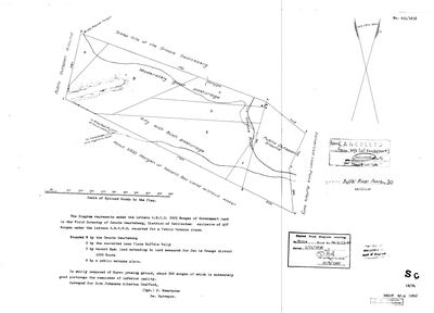 Surveyor-General diagram, 631/1838, 1 November 1838
10598528.jpg
Cadastre
Surveyor-General diagram index for this parcel
Research notes
SG diagram 631/1838 (DOC-0330, SRC-507): 2005 morgen of Government land in the FIELD CORNETCY OF GROOTE SWARTEBERG, District of Swellendam, plus 497 morgen reserved as a public outspan. Bounded north by the Groote Swarteberg.
*** SURVEYED FOR DIRK JOHANNES ALBERTUS CRAFFORD. *** He is on the FamilySearch chart A CRAFFORD HOLDING NAMED GROUND IN THIS FIELD-CORNETCY, eight years after his brother married an Oosthuizen. [TO VERIFY] - identified on name and date against the chart, with no baptism or death notice read against the diagram. LEAD-0252.
'Is wholly composed of Karro grazing ground, about 500 morgen of which is moderately good pasturage the remainder of inferior quality.' The face marks the road to Beaufort over the Swartberg and the road to Cape Town through Cogmans Kloof.
NOT CORE AND NOT IN THE KOUP: no plc_id, so scope.in_koup fails closed and the map's opening bounds stay on Klaarstroom. 9a - a prequel ground is drawn so the road can be seen, never grown into a second district.
The research behind this page, kept separate from it: dated working notes, open questions, and what is not yet settled.
What the record is missing
-
Nobody is on record as ever having held this
third order · B8 never-held
Buffel Rivier Poort No. 30 (Ladismith) is in the model and drawn on the map, and carries no ownership record of any kind, not a grant, not a transfer, not an occupation.
What would settle it The Surveyor-General's diagram for the farm number names the grantee and the date; the deed reference on it opens the transfer chain.
Found by breaks.py reading the model against itself, not written by hand,
each one is a shape of missing record, not a fault in the data.
The whole set is on the
questions page.