Alewyns Berg No. 694
· on record 1914 · show on the map
- Farm number
- No. 694
- District
- Calvinia (division)
- Extent, as the diagram states it
- 1586 morgen 250 sq roods
- Modern surveyed area
- 1421.3 ha
The historic extent and the modern surveyed area are two separate measurements and are not presented here as confirming each other. The first is what a surveyor wrote on a diagram, usually in morgen. The second is what the modern cadastre draws.
Why this farm is here
Described by a document in this collection. 338 km from Klaarstroom.
- document A document in the collection describes this ground DOC-0274
What the record holds, in order
- March 1914 document SG diagram Fr. 815/1914
Also bordered by, as the modern cadastre draws it
Ground that touches this farm on the Surveyor-General's current polygons and that none of the diagrams held here names. Derived from the geometry, not read off a document.
Documents
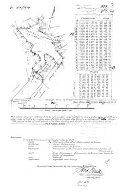 Surveyor-General diagram, Fr. 815/1914, March 1914
10054898 694 0.jpg
Research notes
[10 Aug 2026, SRC-364/DOC-0274] THIS ONE ADJOINS TYGERHOEK, and that is why it matters. Fr. 815/1914, surveyed and beaconed March 1914 by Fred Muller, Government Land Surveyor, in the FIELD CORNETCY OF VOOR HANTAM - Tygerhoek's own cornetcy. Its boundary list ends 'North West by TYGERHOEK and Inkruip'. TWO FARMS CARRY THE NAME ALEWYNS BERG IN ONE DIVISION and they are not the same ground: No. 668 (PAR-000191) is Crown land in NORTH ONDER BOKKEVELD, surveyed 1874; this is No. 694 in VOOR HANTAM, surveyed 1914, and they sit in different cornetcies. Never conflate them - the 9 two-Middelwaters trap, now a two-Alewyns-Bergs trap. IT SITS AGAINST AKKERENDAM, which is the nature reserve immediately north of Calvinia town, and its neighbours read as one continuous block: Ambraols Hoek, Annex Akkerendam, Akkerendam Extension, the Remainder and a deducted portion of Akkerendam, a deducted portion of Hoogekraal, and Inkruip. Every boundary is defined 'by upper edge of Cliff', so the farm is the top of a mountain. The face also names Vlakhoek, Groot Toren, De Zoom and a Spring. A modern hand adds 'Included in Proclamation S.G. 618/2017'. 1586 morgen 250 roods is about 1,358 ha against the modern 1,421 ha, 4.6% more today.
The research behind this page, kept separate from it: dated working notes, open questions, and what is not yet settled.
What the record is missing
-
Nobody is on record as ever having held this
third order · B8 never-held
Alewyns Berg No. 694 is in the model and drawn on the map, and carries no ownership record of any kind, not a grant, not a transfer, not an occupation.
What would settle it The Surveyor-General's diagram for the farm number names the grantee and the date; the deed reference on it opens the transfer chain.
Found by breaks.py reading the model against itself, not written by hand,
each one is a shape of missing record, not a fault in the data.
The whole set is on the
questions page.