Alewyns Berg No. 668
· on record 1874 · show on the map
- Farm number
- No. 668
- District
- Calvinia (division)
- Extent, as the diagram states it
- 1861 morgen 273 sq roods
- Modern surveyed area
- 1596.8 ha
The historic extent and the modern surveyed area are two separate measurements and are not presented here as confirming each other. The first is what a surveyor wrote on a diagram, usually in morgen. The second is what the modern cadastre draws.
Why this farm is here
Described by a document in this collection. 368 km from Klaarstroom.
- document A document in the collection describes this ground DOC-0272
What the record holds, in order
-
1874
document
SG diagram 313/1874
Title Clv. Q. 17-8 dated 16.10.1893
Also bordered by, as the modern cadastre draws it
Ground that touches this farm on the Surveyor-General's current polygons and that none of the diagrams held here names. Derived from the geometry, not read off a document.
Documents
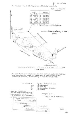 Surveyor-General diagram, 313/1874, 1874
10054505 668 0.jpg
Research notes
[10 Aug 2026, SRC-362/DOC-0272] 'Lot B Alewyns Berg', a CROWN LAND farm surveyed 1874 by Wm. de Smidt Junr. - the same surveyor who laid out Tyger Hoek Extension five years later. Field-cornetcy of NORTH ONDER BOKKEVELD, which is a different part of the Calvinia division from Tygerhoek's Voor Hantam. Title Clv. Q. 17-8 of 16 October 1893. Bounded N by Plaat Fontein Extension, NW by Brak Laagte, SW by Dwars Pad, S by Alewyns Berg Extension, E by Driekop. Beacons pointed out to Field Cornet J.A. Nieuwoudt, S.V. van Breda and J. Poole. The extent agrees with the modern polygon to 0.15%. WHY IT IS HERE: ALEWYN IS A NAME IN THIS LINE. Jacobus Alewyn van der MerweM (PER-001633, 1804-1870) is a direct ancestor, and his daughter's marriage to her first cousin is the join SRC-346 uncovered. Whether the mountain is named for him, for his father or for an unrelated Alewyn is NOT established and is not guessed. [TO VERIFY] LEAD-0149.
The research behind this page, kept separate from it: dated working notes, open questions, and what is not yet settled.
What the record is missing
-
Nobody is on record as ever having held this
third order · B8 never-held
Alewyns Berg No. 668 is in the model and drawn on the map, and carries no ownership record of any kind, not a grant, not a transfer, not an occupation.
What would settle it The Surveyor-General's diagram for the farm number names the grantee and the date; the deed reference on it opens the transfer chain.
Found by breaks.py reading the model against itself, not written by hand,
each one is a shape of missing record, not a fault in the data.
The whole set is on the
questions page.