Part of Rhemhoogte No. 125
Rhemhoogte No. 125 Ptn 1
· on record 1883–1971 · show on the map
The farm's own history, the grant, the original survey, sits on that page.
- Farm number
- No. 125
- Portion
- 1
- District
- Prince Albert
- Extent, as the diagram states it
- 5305 morgen 535 sq roods (text); 5097 morgen 1609 sq roods (rectified area)
This parcel has no matched survey polygon, so it cannot be drawn on the map. That is a gap in the cadastre match, not an absence from the record.
Why this farm is here
A piece of a farm already in this model. Not yet placed on the map.
- parcel Cut out of Rhemhoogte No. 125
- parcel Ground cut out of this farm: Groot Sleutelfontein (Rhemhoogte No. 125 Ptn 2)
- parcel Consolidated into: Swartskraal (Rhemhoogte No. 125 Ptn 5)
- document A document in the collection describes this ground DOC-0173
What this farm became
From 1883 this ground stopped being one farm, and the story continues on the pieces cut from it. Its own record above ends there; what happened afterwards belongs to a portion, not to the whole.
What the record holds, in order
- 1883 boundary change subdivision: becomes Groot Sleutelfontein (Rhemhoogte No. 125 Ptn 2)
-
1883
document
SG diagram 978/1883
P.A.Q. 2-20
- 1971 boundary change consolidation: becomes Swartskraal (Rhemhoogte No. 125 Ptn 5)
Documents
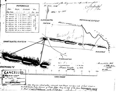 Surveyor-General diagram, 978/1883, 1883
SCAN337 125 portion 1.jpg
Research notes
[3 Aug 2026, SRC-207] ONE HALF OF RHEMHOOGTE AS GRANTED. Diagram 978/1883 describes it as "being one-half of the farm RHEMHOOGTE granted to Mess[rs] J and J A Oosthuysen on the 1st July 1879" - the grant our OWN-000060 records as P.A.Q. 2-20 to "(J.)A.A. Oosthuysen & another". Cancelled 13.4.1974 vide Farm 125/5. Portion 2 (PAR-000140) was cut out of it in 1883. No polygon: the diagram is pre-coordinate and the parcel no longer exists as such.
[13 Aug 2026] Renamed to the one form this model uses for every portion - the portion's own name, then the parent farm, its number and the portion in brackets - so that a name is legible in a list, a search result and a map popup without the reader having to know which farm number is which. It read "Rhemhoogte Portion 1 (No. 125 Ptn 1)" before. Nothing about the ground changed.
The research behind this page, kept separate from it: dated working notes, open questions, and what is not yet settled.
What the record is missing
-
Nobody is on record as ever having held this
third order · B8 never-held
Rhemhoogte No. 125 Ptn 1 is in the model, and carries no ownership record of any kind, not a grant, not a transfer, not an occupation.
What would settle it The Surveyor-General's diagram for the farm number names the grantee and the date; the deed reference on it opens the transfer chain.
Found by breaks.py reading the model against itself, not written by hand,
each one is a shape of missing record, not a fault in the data.
The whole set is on the
questions page.