Part of Klipgat No. 114
Klipgat A (Klipgat No. 114 Ptn 2)
· on record 1911–1916 · show on the map
The farm's own history, the grant, the original survey, sits on that page.
- Farm number
- No. 114
- Portion
- 2
- Also recorded as
- Klipgat ADIAGRAM, deduction table on SG dgm 1200/1911, DOC-0159KlipgatSRC-436, 2023 valuation roll, which prints the parent farm name against this portion
- District
- Prince Albert
- Extent, as the diagram states it
- 2134 morgen 320 sq roods
- Modern surveyed area
- 1830.1 ha
The historic extent and the modern surveyed area are two separate measurements and are not presented here as confirming each other. The first is what a surveyor wrote on a diagram, usually in morgen. The second is what the modern cadastre draws.
Why this farm is here
Jacobus Johannes Petrus van Zyl held it, and no kinship to the Oosthuizen, Marincowitz or Van der Merwe lines is recorded, this ground entered through the land, not the family. 29 km from Klaarstroom.
- parcel Cut out of Klipgat No. 114
- border Shares a boundary with Aschkop (Klipgat No. 114 Ptn 10) Aschkop (Klipgat No. 114 Ptn 10)
- document A document in the collection describes this ground DOC-0194
- lead An open question in this record is about this ground The estate of Louis Daniel Francois van Zyl (d. 1900), who held Klipgat No. 114
Before this ground was cut out
This is the history of Klipgat No. 114, the farm this ground was cut from, on a date the record does not give. It is shown here because this ground was that farm, and separately from what follows because before the cut the record says the farm's name and not which part of it. Not everything below necessarily happened on this piece.
- 1910-09 document SG diagram 1200/1911 D/G P.A.Q 6-7
- 1911 document SG diagram verso 1200/1911 (verso)
- ../1911 to 1911-09-24 ownership Louis Daniel Francois van Zyl (1832–1900) quitrent · estate · confidence high
- 1911-09-24 to 1916 ownership Louis Daniel Francois van Zyl (1832–1900) quitrent · amended title · confidence high
- undated boundary subdivision: becomes Zoutwater (Klipgat No. 114 Ptn 1)
- undated boundary subdivision: becomes Klipgat A (Klipgat No. 114 Ptn 2)
- undated boundary subdivision: becomes Lot A (Klipgat No. 114 Ptn 3)
- undated boundary subdivision: becomes Rivervale (Klipgat No. 114 Ptn 4)
- undated boundary subdivision: becomes Bulhouwer (Klipgat No. 114 Ptn 5)
- undated boundary subdivision: becomes Nieuwe Dam (Klipgat No. 114 Ptn 6)
- undated boundary subdivision: becomes Kalkgat (Klipgat No. 114 Ptn 7)
- undated boundary subdivision: becomes Bontwater (Klipgat No. 114 Ptn 8)
- undated boundary subdivision: becomes Quaggas Poel (Klipgat No. 114 Ptn 9)
- undated boundary subdivision: becomes Aschkop (Klipgat No. 114 Ptn 10)
What the record holds, in order
-
December 1911
document
SG diagram 2085/1912
Transfer 8821 of 15.11.1916
-
15 November 1916
ownership
Jacobus Johannes Petrus van Zyl (1862–1941)
freehold · transfer · confidence high
- undated boundary change subdivision: from Klipgat No. 114
Also bordered by, as the modern cadastre draws it
Ground that touches this farm on the Surveyor-General's current polygons and that none of the diagrams held here names. Derived from the geometry, not read off a document.
- N Rivervale (Klipgat No. 114 Ptn 4)
- NE Nieuwe Dam (Klipgat No. 114 Ptn 6)
- SE Aschkop (Klipgat No. 114 Ptn 10)
- W Lot A (Klipgat No. 114 Ptn 3)
Documents
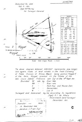 Surveyor-General diagram, 2085/1912, December 1911
10TSOD01 114 2.jpg
Cadastre
Surveyor-General diagram index for this parcel
Surveyor-General diagram index for the whole farm, where the original survey of this ground sits.
Research notes
[1 Aug 2026 inbox] One of TEN near-equal subdivisions cut from Klipgat No. 114 and all registered in 1916 on consecutive deeds, from the deduction table on the reverse of SG Dgm 1200/1911 (DOC-0159). Named Klipgat A on that table, 2,134 morgen 320 square roods, deed 1916-142-8821. THE SHAPE OF IT: nine of the ten are within four morgen of 2,137, and the tenth is a 10-morgen Lot A that is almost certainly a water or building site. Ten near-equal shares registered together, on an amended title issued to the ESTATE of the late Lucas Daniel Fromon van Zyl, is an estate being divided among heirs. The same pattern as Spreeufontein's three-way 1909 split, at ten times the width. [TO VERIFY] against the 1916 transfer deeds, which would name the heirs. The portion number comes from the order of the deed numbers (8820 to 8831 against portions 1 to 10), which agrees with the legible handwritten annotations; two of those annotations are not cleanly legible and rest on the order alone. The block also appears on the FACE of the 1911 diagram as a coloured internal division, so the ten were laid out before they were registered. MODERN EXTENT WILL NOT MATCH: the cadastre's ten Klipgat polygons total about 21,717 ha against the parent's 21,379 morgen (18,312 ha), and the cadastre also carries a 15/114 that is not on this sheet. Historic morgen and modern hectares are never quoted here as confirming each other. [1 Aug 2026]
[3 Aug 2026, SRC-228] ITS DIAGRAM AND ITS PEOPLE. Dgm 2085/1912: 2134 morgen 320 square roods, "portion KLIPGAT A of the farm Klipgat granted to the ESTATE OF THE LATE LOUIS DANIEL FRANCOIS VAN ZYL on the 9th Sept 1911", transferred on deed 8821 of 15 November 1916 to JACOBUS J.P. VAN ZYL.
The research behind this page, kept separate from it: dated working notes, open questions, and what is not yet settled.
Open questions
-
The estate of Louis Daniel Francois van Zyl (d. 1900), who held Klipgat No. 114
priority 1 · LEAD-0096
Does his death notice name Christiaan Hendrik and Jacobus Johannes Petrus among the heirs, and Klipgat among the estate property?
What would settle it A Cape death notice names the surviving spouse and every child by name, and the estate file lists the property. Both halves in one document.
What the record is missing
-
The record stops in 1916 and never resumes
second order · B2 trail-ends
Klipgat A (Klipgat No. 114 Ptn 2) was worked as far as 1916-11-15, with Jacobus Johannes Petrus van ZylH the last owner on record. 110 years follow with nothing. Who held it after that, and is it still one farm?
What would settle it The current title deed traced backwards, each transfer names the one before it, or the Surveyor-General's subdivision diagrams, which are what usually explain a farm going quiet.
Found by breaks.py reading the model against itself, not written by hand,
each one is a shape of missing record, not a fault in the data.
The whole set is on the
questions page.