Part of Spreeuw Fontein & Toornits Kraal (Spreeufontein No. 26)
Klein Waterval (Spreeufontein No. 26 Remainder)
· on record 1897–1903 · show on the map
The farm's own history, the grant, the original survey, sits on that page.
- Farm number
- No. 26
- Portion
- Remainder
- District
- Prince Albert
- Extent, as the diagram states it
- 4137 morgen 397 sq roods
This parcel has no matched survey polygon, so it cannot be drawn on the map. That is a gap in the cadastre match, not an absence from the record.
Why this farm is here
J.C. Muller held it, and no kinship to the Oosthuizen, Marincowitz or Van der Merwe lines is recorded, this ground entered through the land, not the family. Not yet placed on the map.
- story A written history is set on this ground The aardvark's hole and the Gatsplaas gold rush, 1871-1892
- parcel Cut out of Spreeuw Fontein & Toornits Kraal (Spreeufontein No. 26)
- parcel The remainder of Spreeuw Fontein & Toornits Kraal (Spreeufontein No. 26)
- border Shares a boundary with Spreeuw Fontein & Toornits Kraal (Spreeufontein No. 26) Spreeuw Fontein & Toornits Kraal (Spreeufontein No. 26)
- …and 2 more, listed in full further down this page.
Stories
- about this farm
The aardvark's hole and the Gatsplaas gold rush, 1871-1892
An aardvark turns up a nugget on Spreeuwfontein in 1871; twenty years later a shepherd finds a second one and five hundred people arrive. 1,042 claims yield 504 ounces. The diggers' village was called Gatsplaas.
What the record holds, in order
-
April 1897
document
SG diagram 1/1903
P.A.Q.6-1
- 1903 boundary change remainder: from Spreeuw Fontein & Toornits Kraal (Spreeufontein No. 26)
-
19 June 1903
ownership
J.C. Muller
amended-title · confidence high
Bordered by, as the diagram names them
- NW Spreeu Fontein
- NE Riet Fontein
- W Lot 2 of Spreeu Fontein
- SE Bok Fontein
- S Groot Waterval (Remainder)
Documents
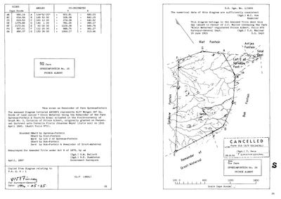 Surveyor-General diagram, 1/1903, April 1897
10FKNP01.TIF
Research notes
The Remainder of "Spreeuw-Fontein & Toornits Kraal". Amended title 19 Jun 1903 to J.C. MullerH, folio 973. Houses and a spring shown on DOC-0016.
[13 Aug 2026] Renamed to the one form this model uses for every portion - the portion's own name, then the parent farm, its number and the portion in brackets - so that a name is legible in a list, a search result and a map popup without the reader having to know which farm number is which. It read "Klein Waterval (Spreeufontein Remainder)" before. Nothing about the ground changed.
The research behind this page, kept separate from it: dated working notes, open questions, and what is not yet settled.
Open questions
-
Spreeufontein drew mineral interest again in 1910-1912, and this record ends the story in 1891
priority 2 · LEAD-0190
Two NAAIRS index lines put mineral activity on Spreeufontein a generation after the rush: an ALLEGED FIND OF CINNABAR in 1910-1911 (KAB SG 3/2/1/35 sys 01 ref MDC770) and THE SPREEUWFONTEIN (PRINCE ALBERT) GOLD MINING SYNDICATE LIMITED, registered under Act 25 of 1892 in 1912 (KAB LC 295 sys 02 ref 1210). What happened on that ground between about 1908 and the First World War, and who was behind the syndicate?
What would settle it Either file. Both would give names, dates and what came of it.
What the record is missing
-
The record stops in 1903 and never resumes
second order · B2 trail-ends
Klein Waterval (Spreeufontein No. 26 Remainder) was worked as far as 1903-06-19, with J.C. MullerH the last owner on record. 123 years follow with nothing. Who held it after that, and is it still one farm?
What would settle it The current title deed traced backwards, each transfer names the one before it, or the Surveyor-General's subdivision diagrams, which are what usually explain a farm going quiet.
-
“Riet Fontein” is named as a neighbour 5 times and we hold no parcel for it
second order · B3 unheld-farm
5 separate surveys in this model put Riet Fontein on the boundary of ground we do hold (PAR-000005, PAR-000020, PAR-000025, PAR-000259). It has no parcel of its own here, so nothing is known about who held it or when, while it borders farms at the centre of the project.
What would settle it The Surveyor-General's farm index for the registration division will give it a farm number and a diagram; the cadastre pull in `fetch_cadastre.py` then places it on the map.
-
“Groot Waterval (Remainder)” is named as a neighbour 2 times and we hold no parcel for it
third order · B3 unheld-farm
2 separate surveys in this model put Groot Waterval (Remainder) on the boundary of ground we do hold (PAR-000020, PAR-000025). It has no parcel of its own here, so nothing is known about who held it or when, while it borders farms at the centre of the project.
What would settle it The Surveyor-General's farm index for the registration division will give it a farm number and a diagram; the cadastre pull in `fetch_cadastre.py` then places it on the map.
Found by breaks.py reading the model against itself, not written by hand,
each one is a shape of missing record, not a fault in the data.
The whole set is on the
questions page.